11/8/2012
Topic:
Difficulty posting
harmono
|
Test. |
11/8/2012
Topic:
Nov 9 Piedras Grandes to Carrizo Gorge
harmono
|
I'm planning a trip out to Anza-Borrego possibly a hike from Piedras Grandes to Carrizo Gorge via an un-named canyon that seems to cut through the range directly to the Carrizo Gorge area. I might check out the tracks if I have enough time, and energy and this route works. From what I can see if I started hiking from the wash just north of Piedaras Grandes and took the north fork of this canyon it would be only 1.5 miles to the train tracks. And the max elevation would be 2400-2600 feet as opposed to the Mortero Palms route that takes you as high as 3400 feet? I don't know if anyone has tried this or if there is an existing path there. It looks do-able, and seems like a relatively safe and easy way to get to the Goat Canyon Trestle.
I have created a Google Map of the path. I am showing the usual Mortero path in yellow, if you look just north of Piedras Grandes, and the wash that goes west of there, there is a green line that cuts through the range. Look at it on a topo map. Not sure if there are any obstacles there?
In the map I have also highlighted the train track in blue up to the Goat Canyon Trestle, and in red after the Goat Canyon Trestle.
edited by harmono on 11/8/2012
<em>edited by harmono on 11/8/2012</em> |
11/8/2012
Topic:
Nov 9 Piedras Grandes to Carrizo Gorge
harmono
|
It's funny you mentioned that, because after reading your post that was one of my concerns. I can't see rocks cactus and brush on the map, or even sand in the wash. I'll have to wait and see. |
11/8/2012
Topic:
Nov 9 Piedras Grandes to Carrizo Gorge
harmono
|
DHeuschele wrote:
I am interested in how it works out. I have used the trespassers route (i.e. walking the tracks) but it is significantly longer than the milage that you believe would be required using this route.
I'll try to document it with my smartphone. |
11/8/2012
Topic:
Nov 9 Piedras Grandes to Carrizo Gorge
harmono
|
Worst part of path? |
11/8/2012
Topic:
Nov 9 Piedras Grandes to Carrizo Gorge
harmono
|
This looks like the most treacherous part of the path. Rocks seem to obstruct the creek path. Not sure how big the rocks are.
http://www.flickr.com/photos/89836383@N03/
See Image
<em>edited by surfponto on 11/9/2012</em> |
11/9/2012
Topic:
Nov 9 Piedras Grandes to Carrizo Gorge
harmono
|
dsefcik wrote:
My guess is it will be more work than think but it is always doable. I lost count how many times I hiked a route to the gorge and it took waayyyy longer than I anticipated.
Now I'm wondering if it will be too muddy. |
11/9/2012
Topic:
Nov 9 Piedras Grandes to Carrizo Gorge
harmono
|
dsefcik wrote:
My guess is it will be more work than think but it is always doable. I lost count how many times I hiked a route to the gorge and it took waayyyy longer than I anticipated.
They certainly don't look like pebbles. We will see. |
11/11/2012
Topic:
Nov 9 Piedras Grandes to Carrizo Gorge
harmono
|
This is an update. I will post complete details on another topic. I drove out there, and might drive out there today. Not much to report. I found the roads too rough for a non 4WD Jeep Liberty to get through, but I did manage to get to the campsite at Mortero Wash. I didn't find a road to get to the wash north of Piedras Grandes, however I did walk across the tracks there, and took a look and took some snapshots. It looks like I would have to walk about 3/4 mile or more to get the the beginning of the canyon I was talking about walking up. This morning I took a look again at the maps, and saw how I might be able to go up Jojobo canyon road back to that wash. I thought the sand was too deep.
I might be going with my brother today who is experienced at this kind of thing and we are going to bring a jack, and let some air out of the tires to get more traction.
I'm not sure if he wants to go out this way, since there are other things out there. Hopefully I will be able to actually walk up to the canyon entrance at least and see what kind of challenges this canyon will pose. The train tracks looked like they had not been used in quite some time. |
11/12/2012
Topic:
Nov 9 Piedras Grandes to Carrizo Gorge
harmono
|
dsefcik wrote:
You can take Dos Cabezas rd straight out to the PG road where you will have to park and walk to where you want to start. There is a road that goes up but it is blocked off now at the Dos Cabezas Rd. 2WD should be fine for Dos Cabezas rd, the sandy section is now graded over by the wind generator project.
http://goo.gl/maps/NYwsB
I tried to drive up Dos Cabesas but I could not figure out how to get through because of all that construction. My GPS was telling me I was on Dos Cabesas, but I suspect that the dirt road that I saw breaking to the right was Dos Cabesas. Next time I'll try that road, if there is a next time, because I was lucky to get a Jeep Liberty to drive around.
I will hopefully get a chance to tell my story and upload pics. At any rate I can still get down Nortero Canyon, but I'll bring a jack, and a chain next time. |
11/12/2012
Topic:
Dos Cabesas Mortero Palms Campground and More
harmono
|
My planned trip was to hopefully check out the possibility of an easier route to the Goat Canyon Trestle via a canyon that cut through the range. There is a wash that is at the northern tip of Jojoba Creek Road. It's also just north of Piedras Grandes, but not the wash that is near Indian Hill. There is no name for this wash on the map that I know, but the trestle that is just north of Dos Cabesas is the southern part of that wash.
This route appealed to me because once you get to the opening of the creek it's about 3 miles to the Goat Canyon Trestle (rough estimate). And from the creek opening to the tracks is about 1.5 miles. Unfortunately there is not a road going to the opening of the creek, but there is a wash. So far I have yet to hear of anyone trying this route.

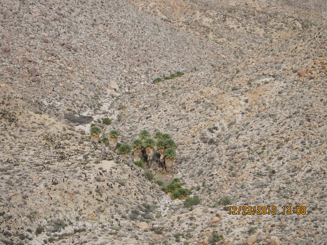
This is a picture that I took of the canyon that I wanted to go through to get to the tracks at Carrizo Gorge.
harmono619, on Flickr
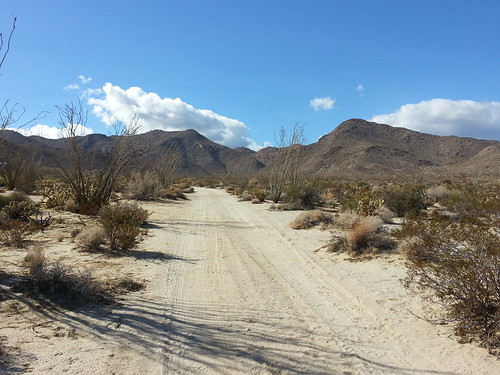
Jojoba Creek road north end near Piedras Grandes by harmono619, on Flickr
I'm working on adding photos.
edited by harmono on 11/12/2012
edited by surfponto on 11/13/2012
edited by harmono on 11/13/2012
edited by harmono on 11/13/2012
<em>edited by harmono on 11/13/2012</em> |
11/12/2012
Topic:
Dos Cabesas Mortero Palms Campground and More
harmono
|
My trip photos
edited by surfponto on 11/13/2012
Map of my planned trip up the canyon (I did not make it there but I took a picture of the canyon from a distance (see inset)

edited by harmono on 11/13/2012
edited by harmono on 11/13/2012
<em>edited by harmono on 11/13/2012</em> |
11/12/2012
Topic:
Dos Cabesas Mortero Palms Campground and More
harmono
|
Google Map
edited by harmono on 11/12/2012
http://www.flickr.com/photos/89836383@N03/page2/
Click on the google map and if you click on a line it will give you the story of each road we went on and where. It's not complete.
Summary:
Day 1 with my Father. Dos Cabesas, Mortero Palms campground
Day 2 with my Brother: Desert View Tower, Wind Farm (Dos Cabesas Road), Bow Willow, Mountain Palms, Unknown Wash (we were trying to get to Mud Caves), Agua Caliente Airport
edited by harmono on 11/12/2012
<em>edited by harmono on 11/12/2012</em> |
11/12/2012
Topic:
Dos Cabesas Mortero Palms Campground and More
harmono
|
I sort of got stung by a bee. |
11/13/2012
Topic:
Pinto Wash Petroglyphs
harmono
|
"Do not fill your hearts with pain and sorrow more memories each morning memories the laughter and joy they quiver solemente ad I've gone though I rest a bale Ascencia dollar and cause" best I could do to translate it. |
11/13/2012
Topic:
Dos Cabesas Mortero Palms Campground and More
harmono
|
TR wrote:
Daren;
I always use Mortero Wash. I air down my tires right after I get off S2. I've never had any trouble with any of the sandy sections.
Tom
That's correct. I never made the trestle or did much hiking. I went down Nortero Canyon (Mortero Wash), with a non-4WD Jeep. It's definitly less complicated to go that way except for finding the railroad crossing. Dos Cabesas is much smoother, but Nortero Canyon is ok if you don't mind a rough road. As far as I could tell the energy company was blocking the path for Dos Cabesas, but that could change in a week or two. So I might go out there for Thanksgiving depending on if I'm lucky enough to get a Jeep again.
I think next time, if this is legal I would like to bring a mountain bike, and see how far I can ride it. I did learn much as this was my first time. |
11/13/2012
Topic:
Dos Cabesas Mortero Palms Campground and More
harmono
|
Yes there are some really sandy sections, on Mortero Wash road so it's a good idea to bring a jack and maybe some planks and lower the air pressure on the tires. But the sand is not really deep as long as you keep your speed, and keep your head about you it's ok. It was just stressful going down that way the first time, because I had no idea what it was going to be like. Going back was much easier, although the sandy parts were difficult because I could not see as well with the sun at that angle.
<em>edited by harmono on 11/13/2012</em> |
11/13/2012
Topic:
November 23rd? Piedras Grandes to Carrizo Gorge?
harmono
|
I'm thinking about returning to this area over Thanksgiving weekend.
My recent trip on Nov 10
Jojoba Creek road north end near Piedras Grandes by harmono619, on Flickr
edited by harmono on 11/13/2012
On November 10, 2012 I drove out to this area in a borrowed Jeep. I'm not sure how I'm getting out there next time, but I hope to get out there Thansgiving weekend.
See my post about the November 9 planned trip. I was trying to find an easier way to Goat Canyon Trestle.
Planned Nov 9 Trip
These are my goals:
1. Try driving up Dos Cabesas Road off S2 to get to Dos Cabesas Station. (Last time I tried the energy construction was blocking the road).
Otherwise try driving down Mortero Wash Road off the S2 to get to Dos Cabesas Station.
2. Cross the railroad track south of Dos Cabesas Station, and get to Jojobo Canyon Road.
3. Take Jojobo Canyon North to Piedras Grandes. Keep going up the road to get to the wash north of Piedras Grandes.
4. Walk up to the north fork of the canyon/wash.
5. Walk up the canyon to the top.
6. Try to view the Goat Canyon Tresle from there, or other sights of the tracks and the gorge, and take pictures.
7. If there is time/water/energy walk to Goat Canyon.
Here is my map plan. Map of my trip
edited by harmono on 11/13/2012
edited by harmono on 11/13/2012
edited by harmono on 11/13/2012
<em>edited by harmono on 11/13/2012</em> |
11/14/2012
Topic:
Pinto Wash Petroglyphs
harmono
|
Daren Sefcik wrote:
Great trip Tom, I always wanted to go out there. There are some pictos you passed by also but they are very faint.
here is what I got from the sign:
"In memory of Martin Zam Torres born 11/29/1969 and passed on 07/20/2008 Do not fill your hearts with pain and guilt instead remember me each day, remember the joy, the smiles and the laughter. I have gone to rest a bit even if my absence causes pain and .....diminishes my pain..."
Every time I find undocumented packs and such I wonder how they do it and why it is worth so much......next time you are out hiking with your cushy Camelbak and name brand boots think of that sign and skull......
Could you explain what you mean by "undocumented packs and such I wonder how they do it and why it is worth so much" - I'm lost here.... I guess I'm a new b. |
11/14/2012
Topic:
Difficulty posting
harmono
|
Is this fixed now? The interface looks different. |
11/14/2012
Topic:
Goat Canyon Trestle Hike
harmono
|
surfponto wrote:
Would love to go but we will be out the following weekend for out annual
Thanksgiving Borrego Trip
Report back after your trip . Sounds like a good time.
Bob
edited by surfponto on 11/5/2012
edited by surfponto on 11/5/2012
I'm thinking of heading out there for Thanksgiving weekend (Maybe Friday or Saturday) I have no idea how I'm going to get there, I have a Saturn, but I might get lucky and have a Jeep again.
edited by surfponto on 11/14/2012 |
11/14/2012
Topic:
Pinto Wash Petroglyphs
harmono
|
Daren Sefcik wrote:
Undocumented travelers backpacks...they are discarded all over the desert. How they do it as in how do they cross such rough terrain over such long distances and sometimes deadly weather with little water or food. To be in the USA for them is worth risking their lives crossing to get here.
harmono wrote:
Daren Sefcik wrote:
Great trip Tom, I always wanted to go out there. There are some pictos you passed by also but they are very faint.
here is what I got from the sign:
"In memory of Martin Zam Torres born 11/29/1969 and passed on 07/20/2008 Do not fill your hearts with pain and guilt instead remember me each day, remember the joy, the smiles and the laughter. I have gone to rest a bit even if my absence causes pain and .....diminishes my pain..."
Every time I find undocumented packs and such I wonder how they do it and why it is worth so much......next time you are out hiking with your cushy Camelbak and name brand boots think of that sign and skull......
Could you explain what you mean by "undocumented packs and such I wonder how they do it and why it is worth so much" - I'm lost here.... I guess I'm a new b.
Oh that's what I thought. I'm not sure if it's just ignorance maybe they don't know how difficult it is, or they are just used to the hot dry climate, and lack of food. At any rate I'm sure they really value getting work here. |
11/14/2012
Topic:
November 23rd? Piedras Grandes to Carrizo Gorge?
harmono
|
Daren Sefcik wrote:
I don't think the wind energy construction project can block public access roads, you should be able to get through on Dos Cabezas Road in 2WD. They may obscure it but not block it.
Post back if you make it out, that looks like an interesting route.
Daren, What I saw was signs saying not to come within 400 feet of construction. The road went right through a construction zone and there were security guards and workers there.
It may be just on that day they happened to be working right by the road. It also may be that I took the wrong road. The entrance was indeed Dos Cabesas, but I saw another road cut to the right. But here is a road that cuts right and goes along the creek bed, and I bet it's really sandy. So I'm not sure. My GPS showed me that I was right on Dos Cabesas, so I turned around. I wish that I had tried that other road, but my brother was wanting to go to the Mud Caves that day. |
11/14/2012
Topic:
November 23rd? Piedras Grandes to Carrizo Gorge?
harmono
|
BorregoWrangler wrote:
Looks like fun! If my plans fall through I'll keep this in mind. I should be out at the Colorado River over Thanksgiving. There's a mountain out there I need to climb!
Do you plan on taking Dos Cabesas road on Saturday out there? If you do, could you take pictures of the construction there? It seemed like the construction was blocking the road. What I saw was the buildings and fences, then I drove about 100 feet and saw a road cut to the right. But if you continue on the road, there was construction going on right next to the road. I'm not sure if the road that cut to the right was Dos Cabesas, or if it was this road that went along this creek that cuts off to the right of Dos Cabesas.
Thanks. |
11/14/2012
Topic:
Difficulty posting
harmono
|
surfponto wrote:
Yeah it is a brand new version of the Forum software.
I imported all the old posts, users etc so it should be good to go.
Bob
harmono wrote:
Is this fixed now? The interface looks different.
Great news, I was getting tired of logging in every time I edited or posted. Thanks so much. |
11/15/2012
Topic:
November 23rd? Piedras Grandes to Carrizo Gorge?
harmono
|
Daren Sefcik wrote:
Here is some obstruction a month or so ago, it threw me off also but I found my way after driving thru their trucks on both sides of the road a little further back. You can see the road on the right with the "No Ocotillo Express Traffic" sign but they have completely bulldozed the road and I could not get over it in my truck.

harmono wrote:
Do you plan on taking Dos Cabesas road on Saturday out there? If you do, could you take pictures of the construction there? It seemed like the construction was blocking the road. What I saw was the buildings and fences, then I drove about 100 feet and saw a road cut to the right. But if you continue on the road, there was construction going on right next to the road. I'm not sure if the road that cut to the right was Dos Cabesas, or if it was this road that went along this creek that cuts off to the right of Dos Cabesas.
Thanks.
This is what I saw. To the left there was some construction. I don't remember if it looked like you could drive through it or not.
edited by harmono on 11/15/2012 |
12/4/2012
Topic:
Nov 9 Piedras Grandes to Carrizo Gorge
harmono
|
I didn't really get around to going there, because of lack of transportation and finding others that want to go. A guy that I work with sounds really interested in going there and he has a truck, so this might happened. I looked at another possible route that seems better. It goes south of Indian Hill, then up a canyon to the same destination as that other canyon. Instead of going on that Jeep trail across, I go south and up this canyon. I have marked this in yellow on my map just north of my other route near Piedras Grandes. I have no date set for this, it will probably be either on Christmas weekend or some time in January. |
12/4/2012
Topic:
November 23rd? Piedras Grandes to Carrizo Gorge?
harmono
|
Yeah I saw that road to the right. I didn't make it out there that weekend. I just could not get anyone to drive me out there, or could not get a truck. However I have found a co-worker or two that has a truck and sound interested. I have revised my planned path to a path that goes from the Indian Hills trestle, then goes up that wash to a canyon that is due south of Indian Hill. The canyon ascends up from it's base about 700 feet to around 2800 feet over about 1.5 miles. Then there is a canyon near "Toy Trestle" that I hope to descend which drops about 300 feet. I don't know this area well. I hope someone who goes out there can take a picture looking up that canyon. I'm talking about going above the 2nd tunnel north of the Goat Canyon tresle. The total trip one way is about 3 miles from Indian Hill trestle to Goat Canyon trestle. The reason I changed my mind is manifold. It's not as steep, it's shorter (if you start from the tracks), on the way back I might swing by the sights in that area. (By the way I'm not sure where anything is in that area). It's south of that road that goes to the railroad construction camp.
https://maps.google.com/maps/ms?msid=200894553877442534046.0004cd8885173c865ca28&msa=0&ll=32.73666,-116.180871&spn=0.012238,0.013819
edited by harmono on 12/4/2012 |
12/4/2012
Topic:
December 26th? Indian Hills Trestle to Goat Canyon
harmono
|
Previously I was planning on going out to Goat Canyon Trestle via an unknown creek/wash that is north of Piedras Grandes. It's not Indian Wash. Now I'm thinking of possibly going from Indian Canyon trestle north of that, and going up that wash to a creek that goes south of Indian Hill. This creek cuts through the mountains, and takes you near "Toy Trestle", and I plan on walking on the hill that the tunnel cuts through south of it there.
Here is a Google Earth video link that explains the path in 3D.
http://youtu.be/GpeCuVnLAFg
I mapped it out on Google Maps.
https://maps.google.com/maps/ms?msid=200894553877442534046.0004cd8885173c865ca28&msa=0&ll=32.73666,-116.180871&spn=0.012238,0.013819
http://www.flickr.com/photos/89836383@N03/
edited by harmono on 12/4/2012
edited by harmono on 12/4/2012 |
12/4/2012
Topic:
December 26th? Indian Hills Trestle to Goat Canyon
harmono
|
surfponto wrote:
I believe that is doable
You could also just take it to the toy trestle and walk up the tracks
Bob
Yeah I'm thinking of going that way on the way back. I made a video tour of this hike on Google Maps in 3D.
http://youtu.be/GpeCuVnLAFg |
12/6/2012
Topic:
December 26th? Indian Hills Trestle to Goat Canyon
harmono
|
Here is an update on this just in case you are following this. Let me know if you are interested in going there. I have changed the date but it's tentative, late December is all I can say.
What's really cool is this panorama photo taken by Deren, I hope he doesn't mind me posting this link.
http://www.darensefcik.com/Photography/Panoramas/16201833_YA53r#!i=1250440396&k=iM7CB&lb=1&s=A
In this panorama I was able to learn things about the area that I could not through other tools. I've been looking for photos of the toy trestle. In this panorama you can see two trestles on the left part (north).
The trestle on the right I believe is called "Toy Trestle" , to the right of that is the area of interest. I was wondering what the descent would be like. What I found interesting is that I suspected that there was a road partially down the descent and I was right apparently. I can see what looks like a road cut out from the side of the hill that seems to go from the north part of the tracks behind a rocky hill, then down towards the tunnel south of the toy trestle. That was confirmation of what I had suspected. I'm not sure if I will be taking this route, but I will probably be trying to document this route for others. I have never heard anyone mention this apparent road even with the controversy surrounding the CZRY police enforcing trespassing laws. This path would reduce walking on or near the tracks to a minimum (or if you just wanted to view the area) in case people are concerned about that. |
12/6/2012
Topic:
Goat Canyon Trestle Via MTB
harmono
|
Just a little train trivia as I'm kind of a new railfan as well as a weekend hiker. The first picture of trains there you see a train marked 7773. I believe at least two of those trains have been sold. In the meeting minutes for SD & AE they mentioned that the buyer of the trains would like them delivered, or would like a refund. So if you notice any cabs missing that's probably the explanation. I think someone else noticed a cab was missing, but I'm not sure which one. The montreal cars probably belong to the Mexican tourist train, so those might be re-claimed after the track is up and running. Just sayin'
http://www.sdmts.com/MTS/documents/2012-7-10COMPLETEPKG.pdf
edited by harmono on 12/6/2012 |
12/18/2012
Topic:
December 26th? Indian Hills Trestle to Goat Canyon
harmono
|
There are a lot of bypass roads out there. I have always wondered about that high road above the tracks, lets us know what you find.
This is the road you are talking about right?
I'm sorry I can barely see that picture, and I could not download it.
I marked the places on this map. One mark is the trailhead from the track, the other mark is what I think I saw as a cutout on the panorama.
https://maps.google.com/maps/ms?msid=200894553877442534046.0004d125b519327568522&msa=0&ll=32.757577,-116.192522&spn=0.01126,0.013819
I can only see it clearly in your panorama shot I think taken from Sacatone overlook, so it must be the same thing, however there are a couple of places, one that leads from the old ruins area (the jeep trail) and another one that is further south I think. My co-worker and I might be going to Sacatone overlook to check that out. How is the road up there? Is it possible for me to drive my Saturn at least close enough to walk half a mile to get there?


Thanks. |
12/18/2012
Topic:
December 26th? Indian Hills Trestle to Goat Canyon
harmono
|
surfponto wrote:
Sorry a little off topic, but I just checked out Daren's panorama shot again.
That is an amazing photo !
Yes it is amazing. Imagine this. I spent hours and hours looking at Google Earth, then I see this picture and clearly before me is this road cut into the mountain.
Also if you look on the left side of Daren's photo (which I cropped above - that's not my photo. Sorry Daren for stealing your pic it's just for illustration.) you will see another road that descends down to the tracks. It seems like there is a road that goes down most of the track there. If the train becomes fully active again ,there might be a way to get to this area without walking on the tracks at all, but it's kind of rough near the Goat Canyon area. There is a road that does go over the tunnel just north of Goat Canyon though.

edited by harmono on 12/18/2012 |
12/18/2012
Topic:
December 26th? Indian Hills Trestle to Goat Canyon
harmono
|
After looking at various maps and aerial photos I have found that indeed a road has been cut through most of this area. It's very clear on this aerial photo. For some reason Google Maps have airbrushed most of this from the picture or the resolution is poor. This road actually cuts out more than a quarter mile from the railroad tracks, and the steepness of the path does not look bad at all. It seems a little rocky in places, but there seems to be nice bushes or palms on part of the route. I wonder what the view is like. This is really interesting. Of course you would miss some of the trestles and tunnels, but who knows what you might find up there, it could be people haven't been up there in years.
edited by harmono on 12/18/2012 |
12/19/2012
Topic:
Looking for a place to camp/sleep with electricity
harmono
|
I have sleep apnea, so I'm somewhat dependent on the CPAP machine which requires electricity of course. But I want to camp or sleep in the desert so I can cut time out of the 2 hour drive out there. Normally what I would do would be to get on Priceline and find a hotel for cheap, but I probably could only find a Hotel in El Centro, or north up near Indio.
I am not totally dependent on the CPAP, it's just that I have a terrible time sleeping, and I'm used to using it. I'm not talking about hiking to a place, then camping, but rather just being in the area. I see a hotel in Jacumba, and Boulevard, and then there is the Golden Acorn. I think there's a hotel in Ocotillo but it doesn't sound recommended. Any suggestions? Maybe I could get some batteries that would last overnight, and an AC inverter. |
12/19/2012
Topic:
Looking for a place to camp/sleep with electricity
harmono
|
DRT Lakeside wrote:
A good bet for a place with electricity would be Agua Caliente County Park. It is close to lots of great places and is very reasonable. I don't think the tent spaces have electricity, but they also have full and partial hook up sites. We use it as a "homebase" pretty often.
As an aside, we stayed there last weekend, and it looks like they are starting to put in some cabins; all the parts were there and many footings were being dug.
http://www.sdcounty.ca.gov/parks/Camping/agua_caliente.html
That looks like a good option. I found out that there are accessories and options for battery powering the CPAP machine. Fortunately newer CPAP machines conserve electricity so it might be feasible. I better get a camping tent, and a sleeping pad. Hopefully there is a cabin for me. |
12/20/2012
Topic:
Looking for a place to camp/sleep with electricity
harmono
|
mrkmc wrote:
We went to Yellowstone for a week on a family vacation and someone in my family used one of those machines. They brought this battery pack that was enough to run the cpap all night in the tent. They recharged it during the day with an ac inverter and also using the power in the restroom at the campground. The battery pack would be way better as you could camp anywhere in the park rather than being limited to regular campgrounds.
Yeah I didn't know there was a battery pack and kit for them. So I'm looking into it. Man time is running out. |
12/20/2012
Topic:
Looking for a place to camp/sleep with electricity
harmono
|
dsefcik wrote:
I have a simple A/C inverter in my truck to charge my GPS, phone or run my laptop if I take it. That may be enough to run your machine and not drain your battery. We actually used it with a big long extension cord going into our house when the Great Blackout of 2011 happened, we powered some lights and radio for most of the night.
That would come in handy, but they are kind of expensive. I was ready to get a generator when the great blackout happened, because I was so miserable. But I guess what I need to do is just get this car charger adapter, and just some battery to car charger clips. Since they run on DC it doesn't make sense to invert from DC to AC and back to DC just for a CPAP. So all I need is this adapter, and I can get the rest at Walmart. |
12/21/2012
Topic:
Dos Cabesas Station Carrizo Sunday December 23rd
harmono
|
I had been planning a trip to see the railroad and possibly go to Goat Canyon Trestle. A co-worker has a truck and we are going to go out there Sunday morning, and just do some casual exploring and if we are motivated possibly hike to Goat Canyon Trestle. I think we are going to drive up Mortero Wash but we might explore the Dos Cabesas road to get there. We may go to the north end of the tracks and park there and walk around. I have some ideas on some roads and paths out there that I would like to check out. See my previous post which proposes a trip on December 26th for more details. If you want to meet us and hike with us send me a note via this forum. |
12/21/2012
Topic:
December 26th? Indian Hills Trestle to Goat Canyon
harmono
|
dsefcik wrote:
I looked thru some of my photos from the last helicopter trip I did out there and didn't find much but there are some cool photos from above.
This one may have something you can zoom in on and see but really...look at this thing, would you ride a train on that..???
Wow! Those are awesome pictures. Especially the one of the Goat Canyon Trestle, one of the best shots that I have seen. It shows exactly what that area consists of.
My Dad did ride on this back in the '70's. The pictures confirm what I'm seeing in other shots. How did you get a helicopter ride there? That would be cool. |
12/24/2012
Topic:
Goat Canyon Trestle from Dos Cabesas Rd
harmono
|
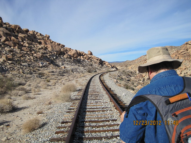
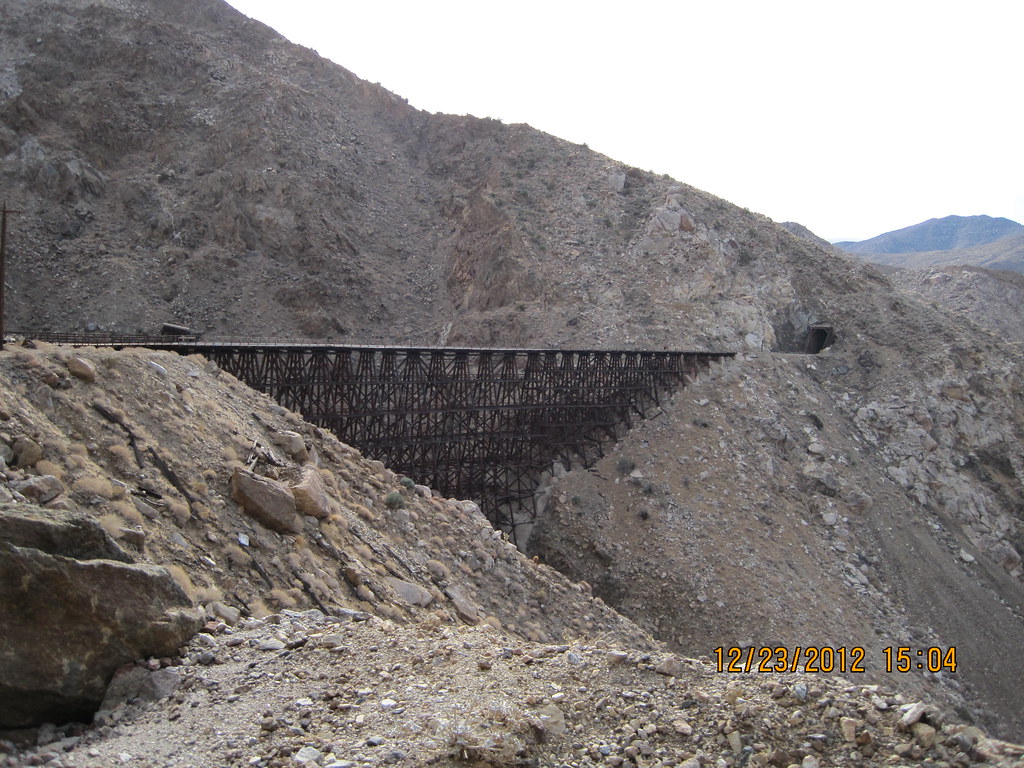
Sunday I walked from the parking spot at Dos Cabesas Rd on the north loop of the track, to Goat Canyon Trestle.
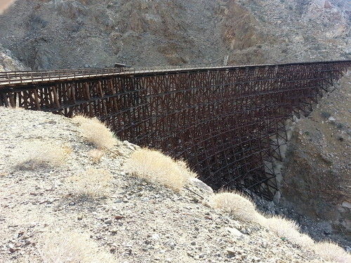
20121223_132206 by harmono619, on Flickr
I hiked with a co-worker who had a truck.
http://www.flickr.com/photos/89836383@N03/8304952947/in/photostream
edited by harmono on 12/27/2012
edited by harmono on 12/27/2012 |
12/25/2012
Topic:
December 26th? Indian Hills Trestle to Goat Canyon
harmono
|
railexplorer wrote:
I'm interested in hearing what you find out. Although it looks like I might be headed out that way in the next week. I've got a young rail fan who really wants to explore the route. For a Christmas present he got a book on the SDA&E. I took a quick look through the book this morning and came across a bit of information for you. In one of the photo captions, it mentions that foot trails were built around all tunnels, to facilitate the movement of equipment and communication between the tunneling crews. Apparently they constructed the tunnels by excavating from both ends and meeting in the middle.
For those of you interested in the book, its the San Diego and Arizona Railway, the Impossible Railroad. By Reena Deutsch.
Oh and finally hello everyone I recently came across this website due to my son's interest in heading out to the Goat Canyon Trestle, this is my first post. Hopefully I'll have more to share soon.
Welcome to the forum. I'm new here too. The railfans (including myself) have invaded I guess. :-). Yeah I made it there on the 23rd, to the Goat Canyon Trestle the hidden man made gem of San Diego County. You know I never thought about reading documentation on the trails, that's right of course, anyways I found them. When I was out there I was looking for the trailhead heading south along the tracks that would circumvent about 5 trestles. I could not find it on the way down south, but I did see the beginning of the path heading north. When I headed north on the tracks I suspected that I found the trailhead, but they had put up a wall that obscured, and almost blocked the path. The path seems treacherous and extremely narrow at some points, probably due to years of rock slides. But parts of it might be usable. The total hike was about 9 miles, about 4.5 miles if you take the tracks from the end of Dos Cabesas road to the Goat Canyon Trestle.
My feet were very much hurting, I'm a heavy guy and the gravel that they put on the tracks and along the tracks made it difficult. That aside it's a fairly easy hike, it's about 2000 feet elevation so you get a little winded at times, especially ascending as you go south, but going down was a breeze. One thing unique about this trek is that there is lots of shade in the tunnels and in the rocks, and you can sit down in the tunnels. The main problem is the lack of cell phone coverage so be sure not to go alone and bring enough supplies and first aid in case something happens. It's kind of dangerous going over the trestles too.
Drop me a note, and I can help you out. I'm working on some maps of the routes, it's difficult to see the train track on Google maps. You can get out there with a decent truck with high clearance, 4WD nice to have but not essential at least on the roads we went on to get here. I posted my trip on the completed trips page, so I will try to include information on how to get there etc. |
12/27/2012
Topic:
Goat Canyon Trestle from Dos Cabesas Rd
harmono
|
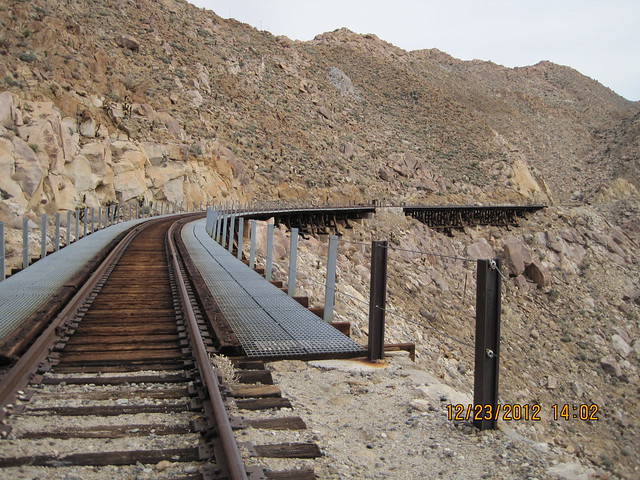
This is the path that we took (the blue line). The red line is the railroad track. The orange/greenish line is this mysterious hidden path that I have been trying to find. I think I know where it is now, it was hidden behind a retainer wall. The trailhead starts with this small wash and the retainer wall prevents the sand from getting on the tracks.
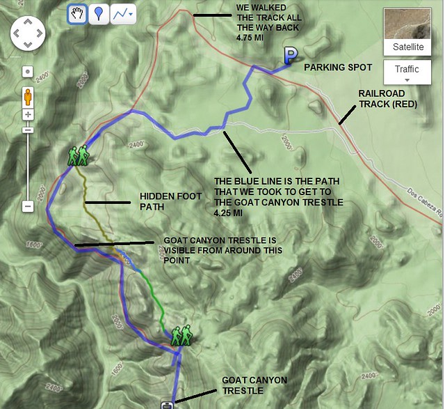
TRESTLEMANIA by harmono619, on Flickr
Here I am embarking on my journey starting with this parking spot at the end of Dos Cabesas road. I wanted to see the Indian Hill area, and possibly cut some distance from the trek. I think it cuts about half a mile from the treck (see map above), but we came back on the tracks entirely (see red tracks on map above)
IMG_0859 by harmono619, on Flickr
I simply found a spot that looked like it was good on the GPS using Back Country Navigator for Android, and off we go. The app kept track of our path that we took, I then traced that in Google Maps (blue line). This is what the landscape looked like at first.

IMG_0876 by harmono619, on Flickr
In case you are wondering what happened to the structure that was made of TNT cans perhaps this photo solves the mystery?
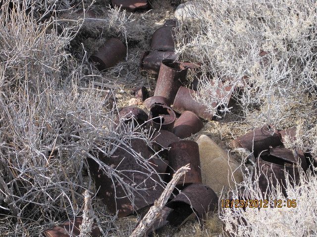
IMG_0879 by harmono619, on Flickr
We found this on the way down south toward the Jeep road. There were other cans and other items strewn about.
We made it to the Jeep trail! Next we head toward the tracks. I'm looking around for artifacts and the construction camp. Lots of stuff but I did not see the TNT can structure. I saw another concrete slab though.
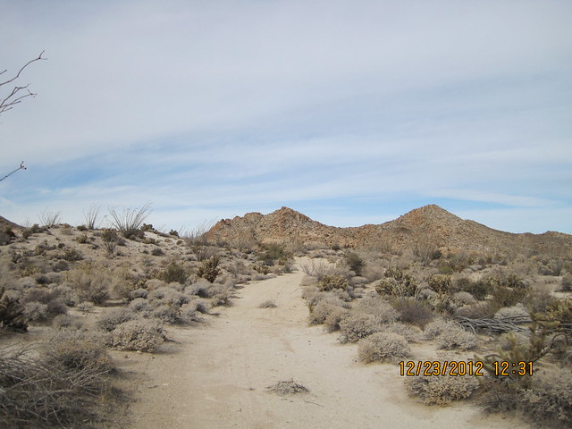
IMG_0887 by harmono619, on Flickr
Not sure what this concrete cylinder is for, but it's dated April 22 1919. Found this along the jeep trail.
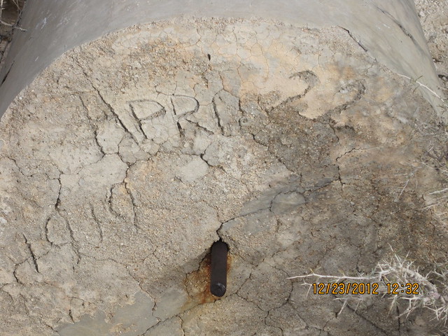
IMG_0889 by harmono619, on Flickr
Our first sight of the tracks from the Jeep trail. The concrete slab was to the left.

IMG_0896 by harmono619, on Flickr
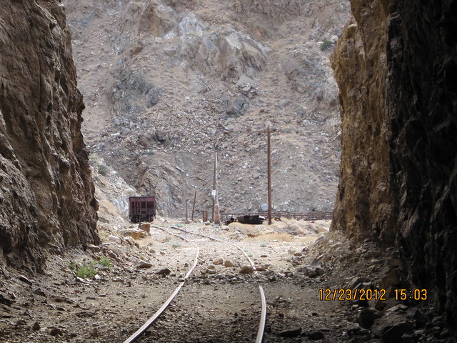
The first tunnel we saw. We did not go in this because we went left (south), however on the way back I believe there was this tunnel and another tunnel that we had not gone through that we went through because we took the tracks all the way back.

IMG_0901 by harmono619, on Flickr
Palms in the canyons below to the right.
IMG_0907 by harmono619, on Flickr
There were mile markers like this one that says "105". This was the first mile marker we saw I believe.
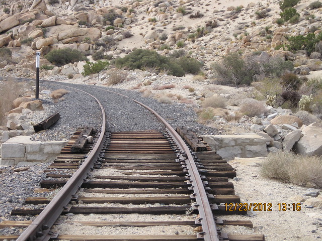
IMG_0916 by harmono619, on Flickr
The gravel along the tracks and on the tracks made it difficult to walk. There were some strong gusts of wind sometimes through the tunnels, and other times the tunnels were calm and warmer than outside because of the wind chill. It was very comfortable temperature wise. Somettimes in the tunnels I was sweating a little, and towards the end it was just a little chilly.
IMG_0935 by harmono619, on Flickr
When we saw the Goat Canyon Trestle in the distance, we were driven to go the full distance although we were playing it by ear. Neither one of us were conditioned hikers, and we are both heavy guys.
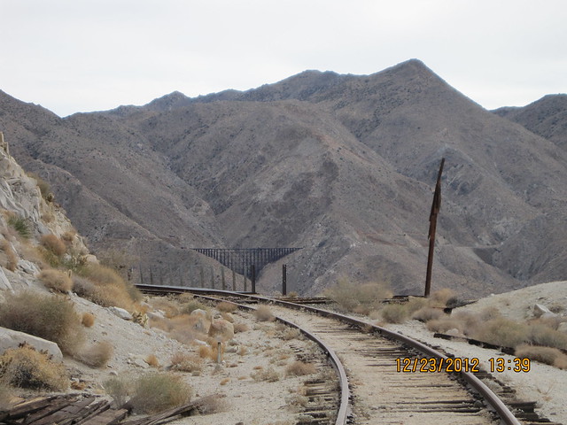
IMG_0948 by harmono619, on Flickr
Some kind of oiling mechanism? We saw many of these on the tracks.
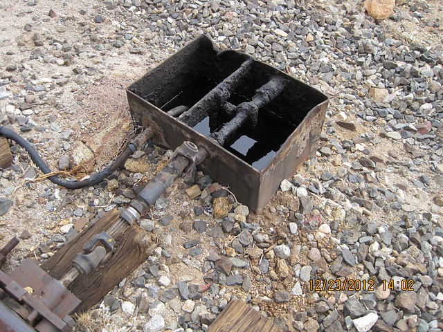
IMG_0974 by harmono619, on Flickr
Apparently due to the sunglasses I was using, and various other factors such as sudden wind gusts, and the weight of my backpack, and my own heaviness, it was scary for me to cross the trestles. I noticed I had sweaty palms. But I noticed that after I ate lunch, and didn't have glasses on, and not as much water to carry, it was not scary at all crossing the trestles. I could not count this to experience, since I was just as scared for each trestle. I did not try to cross Goat Canyon Trestle. My friend Mike went about 1/3 of the way and stopped, because the winds were blowing the trestle! He did not complain of being afraid.
IMG_0976 by harmono619, on Flickr
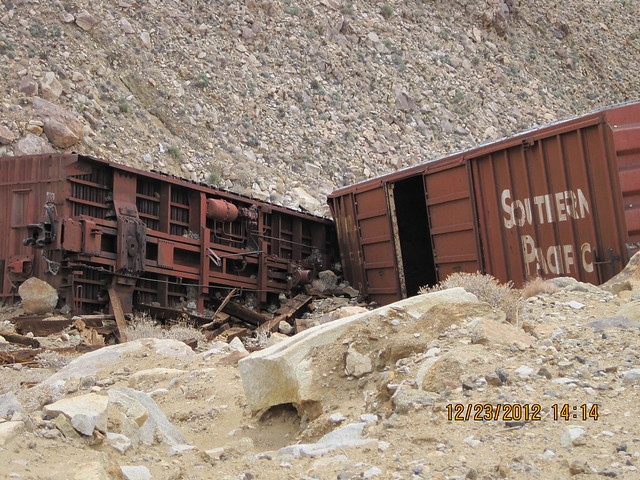
My father told me that he had an opportunity to ride on these tracks back in the '70's before Hurricane Kathleen hit. He said that one of the boxcars was on the side of the canyon and had Coors beer in it which people were helping themselves to. I'm not sure if it's these boxcars or not. This photo is misleading. These boxcars seemed to be suspended by nothing, and could fall down the canyon if I would just blow on them!
More on the beer can story here:
http://www.google.com/url?sa=t&rct=j&q=carrizo%20gorge%20beer&source=web&cd=1&cad=rja&sqi=2&ved=0CDsQFjAA&url=http%3A%2F%2Fwww.myspace.com%2Fvideo%2Fjeff%2Fcarrizo-gorge-beer-can-story-evening-version%2F3970116&ei=oL_cUO2uM8G0igLuioCYAQ&usg=AFQjCNF4zkKd58_MfpFpnpesye1F7Xkxzw
IMG_0993 by harmono619, on Flickr
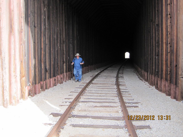
The last tunnel before reaching Goat Canyon Trestle. I ate lunch there while Mike played around. My feet were very sore by this time.
IMG_1031 by harmono619, on Flickr
edited by harmono on 12/27/2012 |
12/28/2012
Topic:
Goat Canyon Trestle from Dos Cabesas Rd
harmono
|
surfponto wrote:
Thanks for posting
Never get tired of Goat Canyon Trestle trip reports 
The route that you took out is the one I want to try also.
Did you see anyone else out there?
Bob
Bob,
Yes we saw 3 mountain bikers as we were on the Jeep trail. We also saw about 6 other hikers along the tracks. One guy did not believe me when I pointed at the Goat Canyon Trestle. I don't think all of them went all the way out ,they started a couple hours after us I think. Just weekenders. The day before I saw 3 cars on Nortero Canyon Road, and I saw a Jeep cross the tracks. Lot's of activity on this weekend.
I also drove around alot and saw Canyon Sin Novembre. On Monday I drove to Salton City. I was going to ride my bike around but the tensioner broke. So I drove up the S22 to Borrego Springs and up the switchbacks.
I bought some pie in Julian for Christmas. |
12/28/2012
Topic:
Goat Canyon Trestle from Dos Cabesas Rd
harmono
|
railexplorer wrote:
Great photos. Thanks for doing the recon work. I'll be using your notes when I head out there soon.
As for the oiling mechanism. That's a greaser for the tracks. You see those on tracks with sharp turns. They automatically grease the wheels as they roll by. It helps cut down the friction and the wear on the wheels and tracks.
Yeah I saw how when the train would go on the track there was a lever there. That's funny, I was at UTC and saw a kiddies train and it was sqeaking really bad. |
12/28/2012
Topic:
Agua Caliente Park
harmono
|
Thanks for reminding me. I was thinking of staying here when I went to Carrizo Gorge last weekend, but I didn't have a car adapter for my CPAP machine. So I'm trying to order one now. This would be a great place to stay. |
12/28/2012
Topic:
Looking for a place to camp/sleep with electricity
harmono
|
waning moon wrote:
Casey,
A little more information on Aqua Caliente, there are quite a few camping sites directly around the hot pool, that have electric and community spigots. This would be perfect for you, to serve as a base camp, close to many Southern ABDSP canyons, roads, interesting sites etc. Not that far to Dos Cabezos either. I see others have posted about Aqua Caliente and it is worth visit, (very noisy though). It is on the San Diego Parks and Recreation web site, you can reserve ahead.
.
Casey Van Tieghem wrote:
I have sleep apnea, so I'm somewhat dependent on the CPAP machine which requires electricity of course. But I want to camp or sleep in the desert so I can cut time out of the 2 hour drive out there. Normally what I would do would be to get on Priceline and find a hotel for cheap, but I probably could only find a Hotel in El Centro, or north up near Indio.
I am not totally dependent on the CPAP, it's just that I have a terrible time sleeping, and I'm used to using it. I'm not talking about hiking to a place, then camping, but rather just being in the area. I see a hotel in Jacumba, and Boulevard, and then there is the Golden Acorn. I think there's a hotel in Ocotillo but it doesn't sound recommended. Any suggestions? Maybe I could get some batteries that would last overnight, and an AC inverter.
I just ordered a CPAP adapter that runs on a car battery, so maybe I would be able to camp further away from the noise, or another quieter place. I think I need to just try it one night and see how it works for me.
Next I need to get a sleeping bag, and a tent. Thanks. |
12/28/2012
Topic:
December 26th? Indian Hills Trestle to Goat Canyon
harmono
|
railexplorer wrote:
I haven't read the book yet, but in one of the captions it mentions that work camps were built at each tunnel, except if two tunnels were close together. The camps were above or below the grade level, wherever they could flatten a spot for tents. There are a couple of pictures of one camp down in the gorge. I'll read up on the chapter about the gorge and let you know if it mentions anything.
That makes sense. I think one of the camps was hidden behind a retainer wall. Next time I go out there I want to explore the camps more, and the trails. I think I want to check out Indian Hill too. This is getting to be a habit for me, but a healthy habit I suppose. I am overcoming the obstacles of having to use a CPAP machine by buying a car adapter, so now I can camp out anywhere, or sleep in the parking lot at Golden Acorn perhaps.
I have a flat bed trailer, but I don't have a hitch installed in my latest car. I might get the hitch installed and use the flat bed as a base so I can just roll into a space and camp, that would be nice. I am starting to see that I might get addicted to this, it's so nice out there, so quiet. |
12/28/2012
Topic:
December 26th? Indian Hills Trestle to Goat Canyon
harmono
|
I just now purchased a Kindle book about the Impossible Railroad. I two books to read now. One written by Neal Peart about his travels via motorcycle around the world, and this book. |
12/28/2012
Topic:
Goat Canyon Trestle and The Impossible Railroad
harmono
|
I noticed an ongoing thread spread across various posts about the Goat Canyon Trestle and the Impossible Railroad.
These threads have some really good information on how to get there, and what you will find there, and some awesome pictures too.
To get the full experience on this forum read all these posts.
My recent trip there:
http://www.anzaborrego.net/AnzaBorrego/Forum/topic437-goat-canyon-trestle-from-dos-cabesas-rd.aspx
My plans for the upcoming trip.
http://www.anzaborrego.net/AnzaBorrego/Forum/topic407-december-th-indian-hills-trestle-to-goat-canyon.aspx
Hiking to goat canyon trestle.
http://www.anzaborrego.net/AnzaBorrego/Forum/topic1-hiking-to-goat-canyon-trestle.aspx
http://www.anzaborrego.net/AnzaBorrego/Forum/topic155-whale-peak--inner-pasture--goat-cyn-trestle.aspx
http://www.anzaborrego.net/AnzaBorrego/Forum/topic383-goat-canyon-trestle-hike-trip-report.aspx
Old Railway Train Parts
http://www.anzaborrego.net/anzaborrego/forum/topic79-carrizo-gorge-old-railway-train-parts.aspx
Via MTB
http://www.anzaborrego.net/AnzaBorrego/Forum/topic409-goat-canyon-trestle-via-mtb.aspx
IMG_1032 by harmono619, on Flickr
I just bought: 'San Diego and Arizona Railway:: The Impossible Railroad' by Reena Deutsch, Ph.D.
www.amazon.com
Surveyors called the San Diego and Arizona Railway (SD&A) "The Impossible Railroad" because of its jagged, mountainous, and brutal desert route. The financier and driving force behind building this binational 148-mile rail
There are some railroad related questions and things that I would like to discuss, and share with others.
edited by harmono on 12/28/2012
edited by harmono on 12/28/2012
edited by harmono on 12/28/2012
edited by harmono on 12/28/2012
edited by harmono on 12/28/2012
edited by harmono on 12/28/2012
edited by harmono on 12/28/2012 |
12/28/2012
Topic:
Goat Canyon Trestle and The Impossible Railroad
harmono
|
This is a Google Map that I created that is a work in progress. Sorry for all the scribbled trails. But it outlines the train tracks for you, and eventually will have some
hiking paths that I have taken that make sense. Feel free to collaborate with me on this map, however I am not sure how that is done exactly. I have tried to open it up to everyone.
I think I can send you an invite via email, but I'm not sure what that will accomplish.
https://maps.google.com/maps/ms?msid=200894553877442534046.0004cd8885173c865ca28&msa=0&ll=32.727292,-116.184797&spn=0.047583,0.055275
Perhaps the admin could help me with the below html:
[html]<iframe width="640" height="480" frameborder="0" scrolling="no" marginheight="0" marginwidth="0" src="https://maps.google.com/maps/ms?msa=0&msid=200894553877442534046.0004cd8885173c865ca28&ie=UTF8&t=m&ll=32.7509,-116.180248&spn=0.069299,0.109863&z=13&output=embed"></iframe><br /><small>View <a href="https://maps.google.com/maps/ms?msa=0&msid=200894553877442534046.0004cd8885173c865ca28&ie=UTF8&t=m&ll=32.7509,-116.180248&spn=0.069299,0.109863&z=13&source=embed" style="color:#0000FF;text-align:left">Carrizo Gorge Railway Map</a> in a larger map</small>[/html]
edited by harmono on 12/28/2012
edited by harmono on 12/28/2012
edited by harmono on 12/28/2012 |
12/31/2012
Topic:
Davies Valley and Pinto Canyon
harmono
|
I found some kind of circle of stones near Bow Willow on top of a knoll. I also found a really small circle of stones near the Nortero Canyon road. I thought it was just a trail marker. Both of them I thought were not pre-historic. I did not see a clearing like in those pictures, but maybe I didn't notice. |
1/2/2013
Topic:
June Wash, Torote Canyon, Indian Hill
harmono
|
Headed home through Dos Cabezas road, and of course lost my way. Ended up driving on the Freeway they have build out there. The security patrol guy stopped me and asked if I was doing work in the area? I consider this to be harassment because it was obvious I was camping having my rig and all, as well as 2 kids riding up front. I can only think he was trying to imply that I am not supposed to be there unless I am doing work. He then asked if I was camping the area? and then asked If I was leaving the area. Next time I am just going to give him the middle finger and be on my way.
I spoke to one of the guards, and he was pretty nice, and helpful and showed me where the "public access" roads were. He understood that all I was trying to do was get to the railroad tracks. He didn't understand that the railroad tracks were in the direction that I was heading. |
1/2/2013
Topic:
Mc Cain Valley Sacatone Overlook 1/6/2012
harmono
|
This is on my wish list of places to go. Is it possible for me to drive my Saturn sedan up to sacatone, or how far can I go?
This is just an old '99 Saturn so I don't mind scratches, but it's front wheel drive, so no way it can handle sand. The road looks pretty straight out there except perhaps that final drive to the overlook. I'm thinking of heading out there this weekend and checking it out. |
1/7/2013
Topic:
7 Days in Anza Borrego Desert State Park
harmono
|
Awesome photos. A friend of mine is into fossils, I'll show him this stuff. |
1/7/2013
Topic:
Mc Cain Valley Sacatone Overlook 1/6/2012
harmono
|
dsefcik wrote:
I would say you should be able to get almost to the base of Tule Mt which is close enough to walk the rest of the way but you could walk the whole thing, it is not that far.
Cool. I'll check it out. I also have some friends who have an Izusu that would get out there, but they don't like to walk at all (not even in shopping malls). But they want to go out and check things out, so I might have them drive around there in a few weeks. I bought a Mountain Bike, and I'm thinking of taking it out there. I'm so busy with all these projects, I guess when it rains I work on my other projects and when it's nice out, I go out. |
1/7/2013
Topic:
Mc Cain Valley Sacatone Overlook 1/6/2012
harmono
|
tommy750 wrote:
I agree with Daren. Should be able to make it out okay. Check out the Carrizo Overlook a couple miles up the road while you're there. Tom
I'm a little confused. I thought Tule and Sacatone were different places. I'll have to re-visit the map and find Carrizo Overlook too. |
1/7/2013
Topic:
Indian Hill Carrizo Gorge Sunday Jan 13th
harmono
|
Well my friend that I went to Goat Canyon Trestle with is talking about going out there maybe this weekend. My feet are still recovering, but maybe we can make it to Indian Hill.
I wanted to check out this hidden path that hopefully will take us to an overlook of Carrizo Gorge and take pictures there. So I'm thinking of setting off from Dos Cabesas Road near the Indian Hill wash, then walk across to the tracks. The only thing is this could be too long of a walk, and too hilly. So we probably will go to the end of Dos Cabesas like we did last time and not go to Indian Hill, but that would be a shame to go out there and not see Indian Hill. That's why it would be nice to have a mountain bike, so we can cover more ground in less time hopefully and with less strain on my feet. Anyways, we will probably play it by ear, but I most certainly want to try this hidden path that I have been talking about (see previous posts).
The hidden path is an alternate path to walking on all those trestles that lead to Goat Canyon Trestle. I have it outlined in this map. When they built the tracks they also cut out some foot paths from the hill, so potentially this would provide an alternate route, however I have reservations about going the whole way, because parts of the path I believe have been eroded, or rock slides have destroyed it. But I would be able to at least walk up the hill which is a more gentle slope than the surrounding hills, and possibly use this path a little to get to an overlook where I would be able to possibly see Goat Canyon Trestle and Carrizo Gorge from about 400-600 feet above the tracks.
https://maps.google.com/?ll=32.750323,-116.175613&spn=0.047571,0.055275&t=p&z=14 |
1/7/2013
Topic:
Goat Canyon Trestle and The Impossible Railroad
harmono
|
surfponto wrote:
Great compilation.
thanks for posting that...
Bob
I'm glad you appreciated it. I wasn't sure where I was going with this. Maybe I'll keep working on it. |
1/7/2013
Topic:
Carrizo Gorge Old Railway Train Parts
harmono
|
hikerdmb wrote:
Daren,
That does look like a great area. Can you send me your GPS track so I can see where you started? Looks like it was a perfect day too.
David
I would be interested too. From what I gather it looks like you started near Jacumba, took a Jeep trail east to a canyon, then went down the canyon toward Carrizo Gorge to the tracks with Mt Tule in the distance. That would only be about 3-4 miles down the track from Jacumba I think. |
1/12/2013
Topic:
Indian Hill Carrizo Gorge Sunday Jan 13th
harmono
|
surfponto wrote:
Hi Casey,
I am guessing the foot paths were used to access the Carrizo Gorge tracks from the railroad camp area.
Yes those are all access roads. I think there are more of them as you get to the camp area near the Jeep trail. The real construction area is further south though towards the end of the gorge. They used a tramway to get up the hill. |
1/12/2013
Topic:
Indian Hill Carrizo Gorge Sunday Jan 13th
harmono
|
We delayed the hike, and I'm relieved, because I was afraid my feet would hurt. I have bought some insoles that are very expensive. Hopefully they will help me in a couple weeks. I can't wait. |
1/17/2013
Topic:
Goat Canyon Trestle and The Impossible Railroad
harmono
|
I periodidally check the SDMTS board meetings regarding the SD&AE railroad because there is a section that gives updates for the "Desert Line" which was the Carrizo Gorge Railway. There was a meeting on January 15th, and there is or was a speaker who is trying to expose PIR who obtained the rights to the railway from SDMTS. (Sorry for the complicated scheme, not sure how to simplify it). At any rate, apparently there could be some litigation, and hesitantcy from people dealing with PIR because of past activity. For example the former President of Carrizo Gorge Railway was sued by the widow of Junior Seau. The whole relevance of this has to do with if there will be any future railroad activity. I personally think it would be great if there was railroad activity although it would get in the way of hiking there. But in the long term the railroad would be maintained (and I'm worried about the Goat Canyon Tresle), and help business in San Diego. It also might some day provide passenger service, and I would like to some day ride on the railroad.
Here is a link to the meeting notes, you can figure it out yourself. If you need more information let me know (due to the sensitivity of the subject, it's sort of vague in public posts).
http://www.sdmts.com/MTS/documents/2013-1-15SDAEPKGFORMAILOUT.pdf |
1/20/2013
Topic:
Goat Canyon Trestle and The Impossible Railroad
harmono
|
This railroad has had many scandals in the past, and this is just the icing on the cake. I did read something in there about one of SDG&E's contractors possibly causing some damage to the tracks, I'm still reading. It's alot of material to go through. I'm just trying to find out what's going on and what the future is for this track.
tommy750 wrote:
Any update on the January 15 meeting, Casey? I'm already tired of Armstrong and Te'o and in need of fresh scandal
Casey Van Tieghem wrote:
I periodidally check the SDMTS board meetings regarding the SD&AE railroad because there is a section that gives updates for the "Desert Line" which was the Carrizo Gorge Railway. There was a meeting on January 15th, and there is or was a speaker who is trying to expose PIR who obtained the rights to the railway from SDMTS. (Sorry for the complicated scheme, not sure how to simplify it). At any rate, apparently there could be some litigation, and hesitantcy from people dealing with PIR because of past activity. For example the former President of Carrizo Gorge Railway was sued by the widow of Junior Seau. The whole relevance of this has to do with if there will be any future railroad activity. I personally think it would be great if there was railroad activity although it would get in the way of hiking there. But in the long term the railroad would be maintained (and I'm worried about the Goat Canyon Tresle), and help business in San Diego. It also might some day provide passenger service, and I would like to some day ride on the railroad.
Here is a link to the meeting notes, you can figure it out yourself. If you need more information let me know (due to the sensitivity of the subject, it's sort of vague in public posts).
http://www.sdmts.com/MTS/documents/2013-1-15SDAEPKGFORMAILOUT.pdf |
1/20/2013
Topic:
Hurricane Kathleen 1976
harmono
|
Yeah cool photos. I remember driving through there in 1980 and seeing the damage. |
1/20/2013
Topic:
Travertine Palms Oasis and Caves
harmono
|
Got it. Nice.
kylekai wrote:
Very interesting. I hope to head that way this weekend and you've given me some areas to explore.
Now for some shameless self-promotion. You can find the 11 or so mud caves and hot springs near the Salton Sea (and another 1,600 other hot springs in the US) with my 99 cent iPhone app Hot Springs of the US:
https://itunes.apple.com/us/app/hot-springs-of-the-usa/id583654750?mt=8
-Bill |
2/3/2013
Topic:
What are you reading?
harmono
|
I'm currently reading a book written by Neal Peart (yeah the drummer for Rush) called Far and Away ( a prize every time). It's about Neal's adventures riding in a motorcycle mostly when touring with Rush. It consists of material that he posted as a blog but is now archived, so you can read recent articles on nealpeart.net. Death Valley is one of his favorite places if not his favorite place to ride. Not sure if he's written about Anza-Borrego yet.
http://www.amazon.com/Far-Away-Prize-Every-Time/dp/1770410597
It's not a bad read, it's got some good pictures. It varies from article to article in how interesting it is, he tends to be a little too self critical, or self conscious about his writing. Neal used to be a bird watcher before he joined Rush in '74, so he's very much into nature, and things like that.
Prior to getting into this book I read the book called The Impossible Railroad which is fascinating.
edited by harmono on 2/3/2013 |
2/3/2013
Topic:
Pacific Crest Trail
harmono
|
My Sister asked me if I would be interested in driving for her when she rides her horses on the Pacific Crest Trail. She wasn't very specific about what her plans were, she just mentioned she will ride from the border to Campo on the first ride. But it looks like part of the trail goes through ABDSP. I apparently will be driving a truck with a horse trailer. I'm not sure where that will take me, but I'm trying to learn as much as I can about this, so I can plan some activities around this in advance. I found the mother lode of maps for this area in case you have not checked this out here's the link:
http://www.pctmap.net/download/p/mapdl.html |
11/12/2013
Topic:
Dos Cabezas and Goat Canyon
harmono
|
This is making me want to go back there. Beautiful pictures. Brings back memories of early 2013 when I went to the trestles. |
6/23/2017
Topic:
Tunes about Anza Borrego
harmono
|
This is cool. Something to listen to while driving out there.
Marco Minnemann is releasing a CD that is about Anza Borrego, and it features guitar work from Alex Lifeson of Rush, and Joe Satriani.
http://lazybones.com/artists/marco-minnemann |