1/12/2015
Topic:
Fish Creek Mountains
dsefcikAdministrator
|
Jim (ziphius) wrote:
Wait a minute... is that an antique UNOPENED can of sardines? Yum. 13 mylars for a single overnight is pretty darn good, must not be too many collectors in that area. naw...notice the church key on the lower right, the can is turned over. |
1/12/2015
Topic:
Indian Valley Summer Solstice Cave & Torote Canyon
dsefcikAdministrator
|
The other fire blackened cave is known as the "wallace" cave, nick named after W.J. Wallace. He also did archeo digs at Indian Hill and many other sites. |
1/12/2015
Topic:
Fish Creek Mountains
dsefcikAdministrator
|
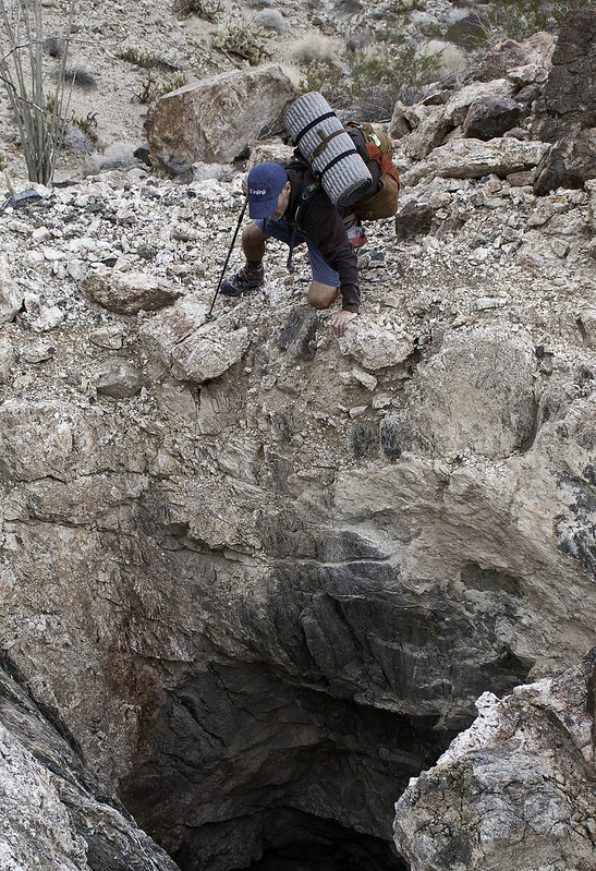
Totally Safe...don't you see my hiking pole holding me steady?? No way that rock under my left hand will slip loose...
Nice Tom, thanks for sharing those...
tommy750 wrote:
Aaannd Daren's life insurance premiums just doubled 
 |
1/13/2015
Topic:
Fish Creek Mountains
dsefcikAdministrator
|
hikerdmb wrote:
Looks like an interesting area. Could you see the bottom of that shaft? Zoomed in sorta...the hole went further in at an angle
 |
1/13/2015
Topic:
Indian Valley Summer Solstice Cave & Torote Canyon
dsefcikAdministrator
|
BorregoWrangler wrote:
FYI: I tried to picked appropriate photos to post of this trip. I've seen other photos from this cave that show much better views of the surrounding landscapes in clear weather... something that I wanted to avoid. I was very careful in selecting the photos I posted and even double checked with others who wouldn't want too much info on the cave accessible to the public. The weather was very stormy and views out from the cave were limited.
Believe me, I would not want to disclose any information that would make it easy for others (who would not respect it) to find such a special place. So feel free to let me know if there are still any measures I could take in this regard. Thanks.
I have PM'd you with my concerns, thank you BW..! |
1/13/2015
Topic:
Fish Creek Mountains
dsefcikAdministrator
|
Nolan (anutami) wrote:
Nice, you guys got pretty far back in there. Daren, your maps look sweet and have great detail. Where did you get those?
What is the deal with the carrizo impact area anyway? Are they still doing bombing drops out there, and why can't you venture in there? ABDSP acquired a large chunk of the impact area and for the time being is closed to public access. There is not any active bombing there (I know of) but there are signs posted near Plaster City on both sides of the RR tracks. I have heard rumors that the impact area may be cleaned up enough to allow public use but that seems unlikely but I am hopeful.I used the ABDSP maps provided here to navigate our way around the impact area boundaries. The map you see on my truck bed is one of the Tom Harrison Maps. They make pretty good durable and water resistant maps. |
1/14/2015
Topic:
Fish Creek Mountains
dsefcikAdministrator
|
Nolan (anutami) wrote:
Thanks, found this sd reader article although it is pretty old http://www.sandiegoreader.com/news/2001/sep/06/risky-wasteland/#
Probably still all about the same, I don't think much has changed since then. |
1/16/2015
Topic:
Wind Turbine Catches Fire
dsefcikAdministrator
|
I was gonna drive out that way today but don't think I will make it...would have liked to see that. Thanks for posting Tom... |
1/17/2015
Topic:
Indian Valley Summer Solstice Cave & Torote Canyon
dsefcikAdministrator
|
So does this count as 2 hikes and you get a weekend off?? |
1/17/2015
Topic:
Indian Valley Summer Solstice Cave & Torote Canyon
dsefcikAdministrator
|
BorregoWrangler wrote:
My next hike will either be Eagle Peak, between Descanso and Julian, or Sweetwater River Trail to Mother Miguel Mountain.
A good but long one is Secret Canyon Trail http://www.sefcik.com/2010/09/secret-canyon-trail-pine-creek.html |
1/20/2015
Topic:
Wind Turbine Catches Fire
dsefcikAdministrator
|
Stopped by on Sunday

 |
1/20/2015
Topic:
Plane Wrecks
dsefcikAdministrator
|
epolomsk wrote:
Did you folks ever find this plane?
http://joeidoni.smugmug.com/Aircraft-Crash-Sites/A/11558268_JnGUE#818002961_s9gHV
I hiked to it last week--its near Agua Cailente. I found it Sunday..will post up a TR tonight hopefully

 |
1/20/2015
Topic:
Sawtooth & Tierra Blanca Mtns Solo Backpack
dsefcikAdministrator
|
Last minute decision to go for a solo backpack trip that was a big loop thru the Tierra Blanca & Sawtooth Mountain ranges. This was an area I had not been to before and was on my todo list. I hiked close to 20 miles total in a day and a half and saw lots of great stuff, definitely worthy of another trip. I have been trying to use just my little Canon S100 camera lately and it takes great pictures when there is good lighting but fails miserably in low light and for star shots. Even with the CHSDK installed it still just cannot handle low light photography well.
On my drive out I stopped at the wind turbine in Ocotillo that recently caught fire

They say a picture is worth a thousand words..so here are a few thousand in no particular order of the trip...


Ocotillo Wind Turbines at night from the top of the Sawtooth Range


Big Prints

Little Prints

Big & Little Prints collide


Drainage I took down into Inner Pasture

Found the jet wreckage that I believe goes with the ejection seat I found on this trip


I saw footprints from 3-4 people that looked like they went up to Red Top, if that was you let me know!
Total Mylar Balloons this trip - 3

A selfie, not sure what inspired this but there you have it....me....only took 20 minutes of fiddling to get that damn camera to balance on a rock just right

More photos in my gallery here
--
|
1/20/2015
Topic:
Wind Turbine Catches Fire
dsefcikAdministrator
|
tommy750 wrote:
Thanks for the pictures, Daren. And, congratulations on being the lucky recipient of my 500th post! You are welcome and Happy 500! |
1/20/2015
Topic:
Sawtooth & Tierra Blanca Mtns Solo Backpack
dsefcikAdministrator
|
Jim (ziphius) wrote:
Cool man. How far was the wreckage from the ejection seat, roughly? (if that doesn't give away too much info). If you were up in a plane high enough you could probably see both....
Jim (ziphius) wrote:
The lighting on that first glimpse into IP is awesome. I've poked around that rim of IP up a particular drainage, but don't think I got as far into "no man's land" as you appear to have gone. Did you venture to the 'spring' area just about due N of Red Top that you checked out on a previous trip? That was early morning after the sunrise photos and yes, it did look that cool in person also, I liked that view a lot! I did go near the spring, that is where I saw all the foot prints going up/down to red top and back thru inner pasture. The BP was crusing the whole valley on Saturday quite intensely via helicopter, I watched them for about 30 minutes from up on the ridge line as they hovered around the valley floor searching every boulder pile. |
1/20/2015
Topic:
Sawtooth & Tierra Blanca Mtns Solo Backpack
dsefcikAdministrator
|
No water, lots of green.
Jim (ziphius) wrote:
Again, that light is amazing. Bummer that the quiet of IP gets interrrupted by BP. I gotta find a more remote hangout. (oh yeah, any evidence of water near the spring?)
dsefcik wrote:
Jim (ziphius) wrote:
Cool man. How far was the wreckage from the ejection seat, roughly? (if that doesn't give away too much info). If you were up in a plane high enough you could probably see both....
Jim (ziphius) wrote:
The lighting on that first glimpse into IP is awesome. I've poked around that rim of IP up a particular drainage, but don't think I got as far into "no man's land" as you appear to have gone. Did you venture to the 'spring' area just about due N of Red Top that you checked out on a previous trip? That was early morning after the sunrise photos and yes, it did look that cool in person also, I liked that view a lot! I did go near the spring, that is where I saw all the foot prints going up/down to red top and back thru inner pasture. The BP was crusing the whole valley on Saturday quite intensely via helicopter, I watched them for about 30 minutes from up on the ridge line as they hovered around the valley floor searching every boulder pile.
edited by ziphius on 1/20/2015 |
1/21/2015
Topic:
Sheep / deer at the water trough?
dsefcikAdministrator
|
That is Bighorn country and looks plausible....guess we will have to stop and take a look next time we are out there...good eye...but I know why you were looking at a water trough to begin with.... |
1/21/2015
Topic:
Sheep / deer at the water trough?
dsefcikAdministrator
|
Jim (ziphius) wrote:
dsefcik wrote:
...but I know why you were looking at a water trough to begin with....
Nothing more fun than 'connecting blue dots' on the map to plan a long trip. Might require some caching. Of course, you're invited. Just let me know the details, you have my contact info. I am half planning some kind of extended backpack trip for Spring Break. |
1/21/2015
Topic:
Indian Valley Summer Solstice Cave & Torote Canyon
dsefcikAdministrator
|
BorregoWrangler wrote:
I host my photos on Photobucket then post the link here. You might try that too. (You'll have to edit and the update the post again for it to show up.)
BW, what I do is after I write mt Blogger post I just select all the text and photos with the mouse, copy and then paste into the forum post and it all shows up! |
1/21/2015
Topic:
Indian Valley Summer Solstice Cave & Torote Canyon
dsefcikAdministrator
|
BorregoWrangler wrote:
dsefcik wrote:
BorregoWrangler wrote:
I host my photos on Photobucket then post the link here. You might try that too. (You'll have to edit and the update the post again for it to show up.)
BW, what I do is after I write mt Blogger post I just select all the text and photos with the mouse, copy and then paste into the forum post and it all shows up!
Do you use the "direct" link from photobucket?
I use SmugMug, I am not familiar with photobucket. I just write my Blogger post using the SmugMug URL's and then publish the post and just copy/paste the text and photos on the page as you see them, magic does the rest I guess. |
1/24/2015
Topic:
Indian Canyon to Borrego Palm Canyon Traverse info
dsefcikAdministrator
|
Wish I could help you out dheuschele but I have not been up the bypass rd in a year or so...but your very trip has been on my list for awhile, if your looking for another person to join you let me know, I do have a 4wd truck that could make it up there. I know they bulldozed boulder alley last Jan or so but I do not know the current condition.
Maybe dzrtwrks or borregolinda can post here, I know they drive that rd frequently. |
1/26/2015
Topic:
Wind Turbine Catches Fire
dsefcikAdministrator
|
That's all I see now when I drive towards Jacumba...
Up on the Sawtooths last weekend when I camped out for the night I could see the red blinking lights from them and both the Ocotillo an Campo turbines, blinking red lights from all over, can't imagine what it looks like from a plane. Doubt they care about La Rumorosa. |
1/27/2015
Topic:
Loop and Olla Wash yet again
dsefcikAdministrator
|
Lots of cool photos Nolan, love the Heavy Metal shirt...what can I say.....
Totally bummed I didn't get out there to hook up with you guys, looks like fun! |
1/27/2015
Topic:
The Domelands: Wind Caves and Slot Canyon
dsefcikAdministrator
|
Very Cool...! 
Great wide angle and pano photos, were any of those from a GoPro?
That whole area looks beautiful. |
1/28/2015
Topic:
Sawtooth & Tierra Blanca Mtns Solo Backpack
dsefcikAdministrator
|
BorregoWrangler wrote:
Another great trip! Nice pics! You think those big tracks were mountain lion? I think so...and the smaller ones bobcat..but maybe kitfox...the big tracks I followed off/on for several miles in and out of a wash, the smaller ones were around a boulder pile with lots of bobcat scat. |
1/28/2015
Topic:
Sawtooth & Tierra Blanca Mtns Solo Backpack
dsefcikAdministrator
|
rockhopper wrote:
Nice to hear you were able to cover over 20 miles with the short days. Great trail report and photos.
That jet crash site looks like they didn't salvage much. This guy says it is one of the better sites he has seen so that probably says something, he seems to have lots of experience with them, I have only found a few. |
1/28/2015
Topic:
The Domelands: Wind Caves and Slot Canyon
dsefcikAdministrator
|
Brad wrote:
Thanks. Those are not from the GoPro though. I just use my normal camera Canon G15 ( until I can get something nicer) and use overlapping portrait shots, take them into Photoshop to stich them together and then play around with lighting and color in lightroom. I find I get much more information this way then using the pano on my phone. Sometimes I'll make several panos and them stich them all together vertically to get a much bigger image then I could do otherwise. Even though some of the built in pano tools you find in newer cameras work pretty good they still don't beat manually doing them with a good stitching software like Hugin or Autopano Giga. I used Hugin for a long time until I started doing really huge and difficult panos and got Autopano, it works really well, highly recommended!
--
edited by dsefcik on 1/28/2015 |
1/28/2015
Topic:
Sawtooth & Tierra Blanca Mtns Solo Backpack
dsefcikAdministrator
|
tommy750 wrote:
That canteen draped across your chest looks like it weighs more than the water/booze it was carrying You'll see it Friday...it is not too heavy really, was trying out Gary's technique, I kinda liked it and it wasn't in my pack. It has some advantages, it is actually a bladder canteen, it squishes/collapses as it empties to keep it from sloshing around and making noise, you can drop your pack and go scout around with it and have some water, the carry bag is insulated and keeps the water cool.
Now that I sold you on it, you want me to stop by the surplus store on my way tomorrow to pick one up for you??  |
1/28/2015
Topic:
Exploring The Island and Myer Valley
dsefcikAdministrator
|
tommy750 wrote:
I stumbled on that cabin in 2005 heading out to Myers Valley. Stopped by last December and it looked about the same. If you have a copy of Chris Wray's "The Historic Backcountry," it has a blurb on this cabin and mentions another a little way down I-8, one I've never seen. It's listed as being at 32 40.39, -116 04.40. On Google Earth, looks like it's on a little rise near where a dirt road peels off the eastbound lanes. While researching for an upcoming trip I saw in the Lindsay book that he mentions this shack was called by some the "Recluse Cabin" and was built by a sheepherder from Holtville in the late 1940's or early 50's. |
2/1/2015
Topic:
Sheep / deer at the water trough?
dsefcikAdministrator
|


-- |
2/2/2015
Topic:
Between the coast and ABDSP
dsefcikAdministrator
|
Nice post...you always carry a large tape measure?? |
2/2/2015
Topic:
Sheep / deer at the water trough?
dsefcikAdministrator
|
tommy750 wrote:
Were there still coins on the edge of the triple trough? Didn't really look too close, it was windy and I didn't want to be seen by highway patrol so I just snapped the photos and left fairly quick....maybe next time. |
2/3/2015
Topic:
Between the coast and ABDSP
dsefcikAdministrator
|
Jim (ziphius) wrote:
Now when I see something, I don't report it. Unfortunately I have come to the same conclusion at times... |
2/7/2015
Topic:
Pres Day and Spring Break Plans
dsefcikAdministrator
|
I am planing some kind of trip for Pres Day weekend and also over spring break, nothing concrete or planned out yet so far but most likely some kind of multi-day backpack trip somewhere. If anybody is interested in joining up for a day or 2 or more let me know. Some areas I am thinking of are Collins Valley, Fish Creek Mtns and/or Sawtooth Mtns areas but am totally open to anything. Flowers should start blooming soon...maybe Henderson Cyn.
A few photos from a recent trip out in Fish Creek (Canon S100)


--- |
2/7/2015
Topic:
Pres Day and Spring Break Plans
dsefcikAdministrator
|
hikerdmb wrote:
When is your spring break? March 28th-12th |
2/7/2015
Topic:
Mortero Canyon Road
dsefcikAdministrator
|
I was out at Thanksgiving and it was normal, a bit sandy near the S2 but probably OK for a semi high clearance 2WD. You could also just go in on the Dos Cabezas road, it is longer but more 2WD friendly. You will need to use the bypass route near the siding water tower thing, that little uphill is completely rutted out, I wouldn't even do it in my Toyota truck, I went around. |
2/7/2015
Topic:
Pres Day and Spring Break Plans
dsefcikAdministrator
|
Nolan (anutami) wrote:
I may try and head out next weekend around our baseball schedule....I would leave around 1-2pm on sat and drive home monday around 12pm . If you need a pickup/shuttle let me know.
Nolan Thanks Nolan, I will let you know...you going out to Fish Creek area again or is it undecided? Email if you want. |
2/8/2015
Topic:
What are you reading?
dsefcikAdministrator
|
Just bought the Kindle version of Tschiffely's Ride: Ten Thousand Miles in the Saddle from Southern Cross to Pole Star
Has anybody else read this story? |
2/8/2015
Topic:
Google Earth Pro is now free
dsefcikAdministrator
|
Somehow I totally missed this post until now...thanks Florian... |
2/8/2015
Topic:
Google Earth Pro is now free
dsefcikAdministrator
|
Looks like this offer is for the Windows and Mac versions only...I use Linux so I am out on this one...
-- |
2/8/2015
Topic:
What are you reading?
dsefcikAdministrator
|
Jim (ziphius) wrote:
Men were more 'feral' back in the day - envious. ... |
2/10/2015
Topic:
Rattlesnake Spring Water Mules Needed
dsefcikAdministrator
|
Looking for some volunteers to help carry some water up to Rattlesnake Springs for our Bighorn Sheep count this year. We have a tentative date planned for Sat March 28th. We will most likely plan a second date also either before or after that date. If you would like to help out and carry some water up let me know....thanks!! |
2/10/2015
Topic:
Presidents Day Weekend Carrizo Gorge Backpack
dsefcikAdministrator
|
Loosely planning to backpack to the old railroad camp down in the gorge this coming Sat the 14th. If time permits I may go further south to all the wheels and debris and possibly take a side trip up to the trestle. If you would like to join me let me know.


-- |
2/10/2015
Topic:
Presidents Day Weekend Carrizo Gorge Backpack
dsefcikAdministrator
|
Nolan (anutami) wrote:
We are going to ditch practice on Saturday and head out to go check out some of the jet crash sites in Blair Sounds fun, if my plans change maybe I'll head out that way! Sent you an email with more info.... |
2/11/2015
Topic:
New Forum
dsefcikAdministrator
|
Morgan Harris wrote:
Does anybody have a map to get to Indian Hill. I was there years ago and have lost my map and wanted to take my 10 and 12 year old sons there this weekend.
Help I'm lost Hi Morgan, I don't think you will have too much luck finding a map posted publicly disclosing the location of Indian Hill, specifically the rock art...hopefully for obvious reasons. You can use caltopo.com to locate a topo map of the area and it will give you the location of Indian Hill in general and the road to get there. I believe Schad's book also has a trip described in it for Indian Hill. |
2/11/2015
Topic:
Presidents Day Weekend Carrizo Gorge Backpack
dsefcikAdministrator
|
surfponto wrote:
Hey Daren,
Mary and I will be out Saturday and Sunday but most likely will have the dogs.
If we are camping in the area we will look for you
Bob Yeah, let me know where you guys are..I may change plans depending on who wants (or not) to go, weather, beer, mood, sun gods, etc.... |
2/12/2015
Topic:
Presidents Day Weekend Carrizo Gorge Backpack
dsefcikAdministrator
|
hikerdmb wrote:
I'll be heading to Death Valley for 4 nights. Can't wait. Sounds fun..I was contemplating Mojave/DV but decided to just stay close to home...be sure to report back..! |
2/17/2015
Topic:
The Impossible Railroad
dsefcikAdministrator
|
dsefcik wrote:
After reading this book about The Impossible Railroad I now understand a bit better some of the things I have seen in Carrizo Gorge and on the railway tracks.
About a mile and a half north of the De Anza Resort there are some wheel and axle debris on the side of the Gorge and down in the bottom. I always thought this was from the railway efforts, turns out to be from a 1928 movie called Beggars of Life (the train wrecks at the end but watch the whole movie anyway)

The Coors Beer car you see in the distance was an accident from a junior engineer that over throttled the train on his first run. Two Coors Beer trailers derailed. Seems the movie on youtube was pulled, it is no longer available to watch. Also, the Coors beer car is not in the picture I noted above, it is much further south and is difficult to view without climbing down into the gorge. |
2/17/2015
Topic:
The Impossible Railroad
dsefcikAdministrator
|
Spent a few days hiking and backpacking around Jacumba and Carrizo Gorge with an emphasis on trying to find some of the old railroad construction camps. Inspired by the book The Impossible Railroad I backpacked out into the Gorge battling the Tamarisk and ticks and found several of the camps, train wreckage, historic artifacts and even more interest in this fascinating story of a railway that was jinxed from the beginning. I encourage you to read this book if you want to learn more about the history and see many unpublished photos of the railroad as it progressed from 1919 to our present day fiasco it still is.
I will post some of my favorite photos of the trip here but you can see many more in my photo gallery here
The railroad tracks are completely blocked off as of 02-14-2015 at the De Anza resort. The old train cars that have been off to the side for years have been pulled up onto the tracks completely blocking access to railway vehicles. You can see in this picture that whatever large vehicle it took to move those rail cars have dented and smashed down the actual tracks. The picture is deceiving, it looks like the rail car is on the tracks normally but they are actually laid cross wise on the tracks, like a big tractor or such just dragged them up and onto the tracks at an angle.

Young & Crooks Camp 1 down in the gorge

Most of the construction sites built up tiered foundations on the hillsides. They were very elaborate and quite impressive


Debris from the construction camp


The May 1965 derailed Coors Beer trailer

The wheels wedged into a dry fall

I found several small rooms dug into the hillsides that must have served as offices or temporary shelters


Thanks to ImpatientHiker for giving me some clues where to find this one

Or perhaps they were the supply rooms for the important stuff

Plenty of beautiful blooms starting to happen now


Most of the tunnel bypass roads were clear but some had landslide debris covering them or worse cholla land mines, this one I did not win, I took heavy casualties, even my hiking pole got several stuck on it!

Here is a nice view down the gorge towards the Seven Sisters and in the foreground is the original tunnel 15

A bit more old debris in some other construction sites


About the only graffiti I wasn't discouraged to see

Total Mylar Balloons this trip - 5 (no pictures sorry..!)
More photos in my gallery here
-- |
2/18/2015
Topic:
The Impossible Railroad
dsefcikAdministrator
|
Jim (ziphius) wrote:
Nice trip. Like the Huell Howser memorial. The rooms / caves are kinda cool too, now you have a place to go to when the SHTF. Those showy pink flowers are a species of Penstemon. Last place I want to be when the SHTF is in one of those dugouts, I was afraid to sneeze inside them! I had the pink flowers marked as Cleveland's Beardtongue, Penstemon clevelandii

-- |
2/18/2015
Topic:
The Impossible Railroad
dsefcikAdministrator
|
tommy750 wrote:
Nice trip report, Daren. So, they just drug the rail cars at Dubber's onto the main track and derailed them?? Would think blocking a bridge or tunnel would make more sense. At least no railroad police in pickups to worry about. Wonder if some barrier was erected on the far side of the gorge. Lots of nice artifact piles or did you make those? Need to check out the book. Looks to me like a big tractor or something just dragged the train onto the rails and left it there, it took some might to do that. Will try and get back out to the north side of the trestle when I can to explore there, should be quite a few more camps and such to check out. There were quite a few others out over the weekend also, bikers and hikers. I decided to park in the De Anza resort since I was leaving my vehicle overnight. Bonus to that was when I got back I was able to just strip down naked and wash myself off and nobody cared, even started up a conversation with one of the locals about hiking out there... |
2/18/2015
Topic:
The Impossible Railroad
dsefcikAdministrator
|
BorregoWrangler wrote:
Nice trip there, Daren! I'm gonna try to get out there this weekend and camp somewhere in the gorge. I may be out again, feel free to email me if you want any company. FYI the gorge is pretty cleared out until just south of Goat Cyn, after that it is all tamarisk and ticks, I pulled 5 off me Sat night at camp.


 |
2/18/2015
Topic:
First time visitor to abdsp and our adventure
dsefcikAdministrator
|
Your 2 rigs saying hello..??
Glad you got to find the jet wreckage, hope Brett liked finding that stuff.
You guys are way past me with the campers, my entire outdoor sleep gear weighed in at 3lbs... |
2/18/2015
Topic:
The Impossible Railroad
dsefcikAdministrator
|
Nolan (anutami) wrote:
Nice addition to the thread Daren! Some of the best photos by far. We drove all the way to the end of the canyon in hopes of seeing your truck but looks like you started from the opposite end. We checked out the crash sites, thanks for the heads up. We also camped in oriflamme and it was very disturbing to find it bone dry. Can't believe this drought, hope the bighorns are hanging in there. Bummer..wish I would have known...I was already camped out at Table Mtn Friday so I just stayed up top, made more sense...maybe next time! |
2/18/2015
Topic:
The Impossible Railroad
dsefcikAdministrator
|
BorregoWrangler wrote:
Thanks. I'll probably come in from the north, drive down as far as I can and then hike in. Maybe use one of the campsites that the workers had in there recently. I doubt that I'll go much further south than Goat Canyon. The CCC guys are still out there, you should see their gear but since it will be a weekend they may not be out working. Here is a photo from last weekend of the camp just below Goat Canyon, look for the red/orange water bags in the lower left

-- |
2/18/2015
Topic:
First time visitor to abdsp and our adventure
dsefcikAdministrator
|
Nolan (anutami) wrote:
Do you know any history about those crash sites?
Most I know is what you found is one plane, it was one of two that collided in mid air I think in the 50's, the other one landed over near mine or plum wash I think..I could be wrong but that is what I remember hearing/reading. Originally the plane crashed into Ghost Mtn and the military dragged it down into the wash and tried to bury it. I am no expert and could be totally wrong but that is the story I have heard. |
2/19/2015
Topic:
The Impossible Railroad
dsefcikAdministrator
|
rockhopper wrote:
Nice pictures and report Daren. Those railroad builders were tough! Bringing a rail line into San Diego when they said it couldn't be done was like putting a man on the moon back then.. Looks like they are permanently damaging the line for good on purpose :-o This section of track has the date 1919, the year the final connecting "Gold Spike" was put into the tracks. I noticed other sections of track with 1949. There have been lots of repairs over the years, maybe the railroad line is not dead yet, just waiting for another John D. Spreckles to come along...

-- |
2/23/2015
Topic:
Help remove Sahara Mustard
dsefcikAdministrator
|
Thanks for the heads up...I know I won't be able to go though, perhaps some other folks can make it. |
2/23/2015
Topic:
The Impossible Railroad
dsefcikAdministrator
|
surfponto wrote:
Nice trip Daren,
It is amazing that there is still "new" stuff to discover in Carrizo Gorge.
So the CCC guys are below the trestle working now? Guessing it is easier to hike in from the North now.
Did a little wine research on Ellena Brothers
Ellena Brothers, Etiwanda
It was soon after the turn of the century that Claudio Ellena came to the United states from Australia, seeking the right location and climate to establish his vineyards. He chose the Cucamonga district c on the warm and sunny slopes of the foothills of the San Gabriel Mountains. Here he felt that wine could be produced comparable to the finer ones of southern Europe, where the Ellenas originated and had been wanegrowers for many generations. He founded his winery at Etiwanda, a few miles northeast of the town of Cucamonga, where his sons John B. and Frank Ellena carry on the family tradition,, producing some of the finest wines of Southern California.
John B. Ellena, the president of the company, and Frank Ellena, the vice-president, own the family enterprise. Two other brothers are active in the winery, Arnold Ellena, the wine maker, chemist, and secretary of the concern, and Louis Ellena, the master distiller. The featured brand is Regina Cucamonga Wine with Ellena Brothers a secondary label. Table wines, sparkling wines, and aperitif and dessert wines of fine quality are produced, available mainly in the Western states. They are marketed in distinctive and original squat or long-necked bottles, trade-marks of the house.
Full article
edited by surfponto on 2/23/2015
Thanks for that Bob, I wonder if these were the bottles, they appear to be broken and unopened

-- |
2/23/2015
Topic:
Carrizo Gorge Backpack
dsefcikAdministrator
|
Thanks Nolan, if the sand drawings and campfires were the worst people could do we would probably be alright, without the parks conservation efforts there would be no place for small minded people to go out and destroy.
Nolan (anutami) wrote:
dsefcik wrote:
BorregoWrangler wrote:
Oh by the way, on our way back from the trestle on our recent hike, we could see the worker's camp down in the gorge and hear the chainsaws going. I wonder how long they'll be working in there? There were 2 camps, one below Goat Canyon and a second further south, Coyote Spike Camp. They have been out there almost 2 years so far it seems like and doesn't look like they are done. We could see chainsaw blood on the boulders and such, but overall they are doing a really good job keeping things cleaned up while they work.
There is also a base camp at the end of Carrizo Gorge Road.


I have also noticed an alarming rate of disrespect out there as well and people seem to think it is Ocotillo wells recreation area. Alot of jeep tracks heading off trail into where ever they want.
Many illegal fire pits

and this was nice to see when getting to the end of the gorge, Luckily my kids didn't see it. I guess they were pissed they couldn't continue with their jeep further up the gorge?

edited by anutami on 2/23/2015 |
2/23/2015
Topic:
The Impossible Railroad
dsefcikAdministrator
|
tommy750 wrote:
More on the recent legal proceedings involving the railroad: http://www.utsandiego.com/news/2015/feb/21/pacific-imperial-new-investors-kinsell-victorville/
edited by tommy750 on 2/23/2015 Doesn't end does it.... |
2/23/2015
Topic:
Carrizo Gorge Backpack
dsefcikAdministrator
|
tommy750 wrote:
After driving nearly seven miles through the beautiful Carrizo Canyon and then being denied VEHICULAR access to the last 500 yards of dirt road. How tragic!

-- |
2/24/2015
Topic:
The Impossible Railroad
dsefcikAdministrator
|
surfponto wrote:
So the CCC guys are below the trestle working now? Guessing it is easier to hike in from the North now. Yep, they have camps setup, one just below the trestle and another further south. Lots of tamarisk gone up to that point, it is an "easy" hike now from the north end from the road. Still bad though from the south end, in just over a single mile of trudging thru tamarisk down in the gorge last week I managed to get myself all cut up and found 5 ticks on me when I got to camp. |
2/24/2015
Topic:
9th Annual Vallecito Day 2015
dsefcikAdministrator
|
If anybody is into this kind of event...there is no charge.
http://theabf.org/vallecito-day-2015
Date:
Saturday, March 28, 2015 - 10:00am to 4:00pm
Join us for the ninth annual Vallecito Day celebrating life on the 1860s frontier and the roles that cattle drives and cattle ranching played on the Southern Overland trail.
Visit pioneer men and women in period attire.
Witness the arrival of trail riders on horseback, and participate in activities for that period in history.
● Tour the Vallecito Stage Station
● Visit the Mountain Man camp for hands-on demonstrations
● Experience historic firearms, frontier equipment and
homestead crafts
● Bring a picnic lunch and enjoy the festivities (No food available)
● Cattle ranching demonstrations and historical talks
● 1850s and 1860s attire is encouraged
● Open to all ages
VALLECITO COUNTY PARK
37349 County Route S-2 (Mile Marker 34-35)
Vallecito Valley, CA 92036
760●765●1188 ● sdparks.org
-- |
2/26/2015
Topic:
Any wildflowers in southern Anza Borrego ?
dsefcikAdministrator
|
http://www.abdnha.org/pages/03flora/reports/current.htm
I think they are almost there...some rain this weekend followed by some sunshine should do it...let me know if you go out Bob, I may try to go out also for the day to try and find some blooms. |
2/28/2015
Topic:
Archaeology Weekend April 11-12th 2015
dsefcikAdministrator
|
 |
3/1/2015
Topic:
Carrizo Gorge Overnight Trip
dsefcikAdministrator
|
Glad you finally made it out there John..that boulder has had many a camper I am sure, we always pass by it and I remember one trip it was full of campfire wood and undocumented remnants. In the past with the Tamarisk getting that far from the north end was nearly impossible unless the creek bed was totally dry. You can find some of my previous posts showing lots of flowing water.
@Ziphius: There are usually pockets of water the further south you go into the gorge past goat cyn but I would not put anything on a map for a trip unless it was noted in a recent visit or a very wet year. There are currently pockets of water in the gorge from de anza all the way to goat cyn but they are far apart, not too deep or in deep thickets of tamarisk and ticks. Definitly usable for water sources though if needed.
Daren
-- |
3/1/2015
Topic:
Missing Hiker
dsefcikAdministrator
|
Nolan (anutami) wrote:
Find it hard to believe someone would abandon all their gear! Any thoughts on why you would "dump" your pack? Nolan, that is a great question, I hike with folks who seem to always want to "leave the packs" while they go hike around and you can ask any of them I hike with that I always complain and say no, I am bringing my pack. I am not a fan of leaving my pack anywhere unless it is a planned day trip while we base camp, too many variables and I never understand why people like to do it. But that said, I know people do it because they think they will be right back or whatever...never a good idea to me personally...
Hope they find him, reading this morning the search is temporarily suspended for weather reasons.
Daren
-- |
3/1/2015
Topic:
Missing Hiker
dsefcikAdministrator
|
tommy750 wrote:
I've been carrying a sat phone on every hike for the past five years so I haven't needed to dump my pack looking for cell service. Have never needed it to make "that one call" but glad to have it along. It's basically another form of health/accident insurance and prices have come down considerably. Inmarsat now has US coverage. Their Isatphone 2 is now about $800 on amazon and you can even buy six month prepaid SIM cards for about $100. Just throwing this out there as a safety/backup option.
Hope the hiker makes it out okay. Another reason why I like hiking with Tom.... |
3/1/2015
Topic:
Missing Hiker
dsefcikAdministrator
|
tommy750 wrote:
I'm a single guy with no kids. You solo hikers with wives and kids and mortgages don't get heat to get one of these?? Just wondering. Honey, I'm going out to the desert (again).......
-- |
3/9/2015
Topic:
Southern Anza Borrego Flower Report 2015
dsefcikAdministrator
|
After spending the weekend with Tom out at Fish Creek and accomplishing very little other than dodging jeeps everywhere I stopped off at Henderson Cyn and the flowers are really blooming, they will probably keep at it for another couple weeks or until the caterpillars kill them all off....either way if you have not gone to see the flowers now is a good time! Early morning or late afternoon is probably best to avoid the high noon sun glare.
Here are some photos from last weekend...enjoy....


-- |
3/9/2015
Topic:
Indian Canyon to Borrego Palm Canyon Traverse info
dsefcikAdministrator
|
There has been water every trip I have done this year out there, can't imagine it is dry now. |
3/11/2015
Topic:
Henderson Canyon road at peak
dsefcikAdministrator
|
Yep..looks like what I saw last Sunday out there, really pretty.... |
3/13/2015
Topic:
Henderson Canyon road at peak
dsefcikAdministrator
|
Florian wrote:
I want to add that except along the road shoulders there didn't see to be much Sahara mustard out in the open areas. Happy for that. There are removal efforts thruought the park, that area is one of them...we pulled some last weekend from there and saw others doing the same. Great to see you noticed... |
3/17/2015
Topic:
Picto Hunting and Pepperwood Trail
dsefcikAdministrator
|
Wish I could have gone with you Tom, always wanted to go down Pepperwood. At least I got to see some of the wildflower blooms on my way home. Nice INS investigative report... I believe the traffic we saw out in Fish Creek was the TDS Desert Safari event traffic and also from the otherwise beautiful weather we had.
-- |
3/31/2015
Topic:
Indian Canyon to Borrego Palm Canyon Traverse info
dsefcikAdministrator
|
Great report...thanks for the details, hopefully others considering doing this route will benefit from your info. |
3/31/2015
Topic:
Carrizo Gorge wildflowers
dsefcikAdministrator
|
Is the train back on the tracks correctly now? |
4/4/2015
Topic:
Sunrise with Zoom Lenses
dsefcikAdministrator
|
More fun with an Olympus 400mm zoom lens from 1970 on a new Fuji XE-1 digital camera. Zoom lenses compress space and can make some very dramatic sunrise or sunset photos, they are a lot of fun!
These were taken from the North Fork of Indian Valley on April 4th 2015 around 6:30am


--- |
4/4/2015
Topic:
Spring Break 2015 Week 1
dsefcikAdministrator
|
Have been out to ABDSP this last week to several places for day hikes or overnight backpack trips, nothing to spectacular so just gonna post some misc photos.
Sunrise Indian Valley
Fishhook Cactus bloom Canebrake

Unfired blank ammo rounds, anyone know what purpose these serve?

Desert Side Notch

Some pretty blooms


View of the ridge going up to Villager and Rabbit Peaks from San Felipe Wash

Rainbow Wash, one of my new favorite places

Fonts Point from Rainbow Wash

Baja Collared Lizard

Rattlesnake Spring Water Cache Trip, was all film that I fogged by opening the film door on the camera by accident..oops...


Clark Dry Lake

Total Mylar Balloons for the week -- Probably 30+...what a mess


-- |
4/5/2015
Topic:
Spring Break 2015 Week 1
dsefcikAdministrator
|
Jim (ziphius) wrote:
Nice point Daren, ornate. Good eyes to spot one that small. I like the lizard. I like the water. Jim Gary actually found that one....right there at our feet as we were talking about some things...he looked down and says "hey, look at that...!" |
4/5/2015
Topic:
Spring Break 2015 Week 1
dsefcikAdministrator
|
tommy750 wrote:
The lizard is with your 400mm? No, 55mm...I took probably 50 pictures each one I would inch closer and closer until he finally ran off.
tommy750 wrote:
I think we took a pic of the exact same plant! Mine was on 3/14/15 and is a lot smaller without the color 156-B? |
4/6/2015
Topic:
Bighorn Sheep in Inner Pasture
dsefcikAdministrator
|
I'll guess marker 41...I have seen sheep in the wash several times before around this time of year, usually with lambs. |
4/7/2015
Topic:
Bighorn Sheep in Inner Pasture
dsefcikAdministrator
|
Damn you guys...I was one valley over in Canebrake....!! |
4/8/2015
Topic:
AB 4/8-9-10
dsefcikAdministrator
|
I will keep an eye out for you Florian..I will be out and about Thurs/Fri also, somewhere north as well, not sure where but keep an eye open for my ubiquitous truck '81 toyota truck.. |
4/9/2015
Topic:
AB 4/8-9-10
dsefcikAdministrator
|
Driving out now, may stop by |
4/11/2015
Topic:
AB 4/8-9-10
dsefcikAdministrator
|
Sorry I missed you Florian, I ended up driving thru Cuyamaca to see if I could photograph any deer...I did get some but only as they were running away...maybe next time..!! |
4/14/2015
Topic:
Escalante: the staircase: trip 2
dsefcikAdministrator
|
Just beautiful...very envious...
They are grown before you know it, my middle boy just turned 21 so I have 20, 21 & 23 now...seems like I was baseball coach just a few years ago.
Nice trip, thanks for posting, we need to hit Mojave soon..!! |
4/22/2015
Topic:
Trail Less Traveled
dsefcikAdministrator
|
Storm - Day Parking at Troutman Mtn which you can access thru the gate at the bottom of Campbell grade. Or Day Parking of the S2 just north of Vallecitio Stage Station Campground right before you get to all the homes. I would NOT recommend you go on to the property of the ranch at the far end of Storm, you will not be greeted with any smiles.
IP - There is a small pull out for parking just north of the marker 41, telephone poles are near it. You can also park at Agua Caliente campground for $3 and go in thru Moonlight Cyn, a more rigorous hike and probably more scenic. You can get to IP from Canebrake but it is longer, any of the routes are fine for a first trip out. It is vast out there so just go and explore, 4/5 hours will not be enough to explore much, I would recommend you try to plan 6-8 hours and take water and some lunch.
Marker 41 & Moonlight Cyn will have the highest chance of seeing bighorn sheep.
Be sure to report back and have fun! |
4/22/2015
Topic:
Trail Less Traveled
dsefcikAdministrator
|
Jim (ziphius) wrote:
Welcome to the forum. Inner Pasture is awful and dangerous, no water, too many cholla, no trails, and occasionally inhabited by bearded, surly misanthropes that camp without clothes because they can, seeing as no one else ever goes there. You won't enjoy it.
|
4/24/2015
Topic:
Old Aerial Photo Site
dsefcikAdministrator
|
nice...even topo's.... |
4/29/2015
Topic:
West of Indian Hill
dsefcikAdministrator
|
Here it is 08/25/2011 so Bob, either your picture is older than that or it has been rebuilt.
 |
4/29/2015
Topic:
West of Indian Hill
dsefcikAdministrator
|
Tom, you put in some mileage on that trip, sorry I didn't join you..I guess we should call you snake man now.... |
4/29/2015
Topic:
Trail Less Traveled
dsefcikAdministrator
|
I wonder if they went out...drew66 TR ?? |
4/30/2015
Topic:
Pine Valley Wilderness
dsefcikAdministrator
|
Nice flora photos...looks like some nice property, I think you need to visit more often. |
5/3/2015
Topic:
Inner Pasture / Spring Break Week 2
dsefcikAdministrator
|
Backpack trip with Tommy750 this weekend, loop trip from Agua Caliente up Squaw Cyn and down into Inner Pasture then back up Moonlight Cyn. I gotta say Squaw was no fun and won't be on my return trip list anytime soon. IP was beautiful as always but the gnats were pretty bad, they were in my face the whole trip but some 99% deet relieved some of it. Didn't take too many photos, Tom may have some to contribute.
Most of these are from my old Olympus mount Sigma 600mm manual focus mirror lens on my Fuji X-E1 with an adapter.


These are from Grapevine Cyn and Sunset Mountain over Spring Break Week 2


-- |
5/4/2015
Topic:
Inner Pasture / Spring Break Week 2
dsefcikAdministrator
|
Total Mylar Balloons this trip - 7 (no picture sorry) |
5/4/2015
Topic:
Inner Pasture / Spring Break Week 2
dsefcikAdministrator
|
tommy750 wrote:
Amazing circular bokeh is Daren's photographic signature  More like Daren's cheap mirror (Catadioptric) lenses....cuz he doesn't have $11,000.00 for a real lens...http://www.imaging-resource.com/news/2013/09/11/understanding-bokeh-the-art-and-science-behind-the-beauty-of-blur-part-1
-- |
5/4/2015
Topic:
Inner Pasture / Spring Break Week 2
dsefcikAdministrator
|
tommy750 wrote:
Jim (ziphius) wrote:
tommy750 wrote:
My favorite is the crow. Amazing circular bokeh is Daren's photographic signature
Raven, gotta be a raven, bill is too big. I like how the clouds managed to just clear out above the mountains in your shot Tom, great vertical symmetry going on in that photo. Bokeh. Thanks for the new vocabulary word.
Just reading up on ravens and crows( http://www.allaboutbirds.org/guide/Common_Raven/id#similar ). The guy was not in a group, looks like he has ruffled neck feathers and was pretty big with a big beak. Thanks for pointing out the now obvious, Jim! Wasn't really paying attention but now I will. If anything he was following us..! I thought there was something about crows vs ravens and hopping vs walking.... |
5/13/2015
Topic:
Carrizo Marsh
dsefcikAdministrator
|
Can't say I am "following" it but I know it is happening. |
5/13/2015
Topic:
Sheep count 2015?
dsefcikAdministrator
|
I'll post the sign up sheet when it comes out, probably pretty soon but in general expect a mandatory pre-count meeting around the 3rd week of June and then the count will be 3 days on the 4th of July. |