12/15/2012
Topic:
First Trips To Baja
surfpontoAdministrator
|
Great story. Really captures the essence of Baja.
You are right in that it is a lot different but there still seems to be pockets where not much has changed.
Speaking of Boojum trees there are large forests of them in the protected area outside of Catavina.
That is where the video was shot.
Adios,
Bob
waning moon wrote:
Boojum trees, were you North of Rancho Santo Ynez?
Well, could go on for days about Baja and by then everyone would have quit the forum, maybe hung themselves. Benn a long time
So many campfires we reminiscised and told tales of our past Baja trips, most pre Highway 1, some after. Basically I remember the unequalled scenery, but the people, the locals meant so much. Sadly so many are gone.
But one favorite story, my father in law being an expatriot of the USA (after being unceremoniously let go by a large military contractor just shy of retirement) lived for a time at Rancho San Jose (Meling) in a trailer park style trailer. Being Swedish as Ida Meling was, they new each (from when he was in San Diego Mountain Rescue) and were friends. My wife and I visited frequently and often her brother would come along.
We left once after a long weeked on Sunday night, traveling quite fast as we had to go to work the next day, it was raining and the road was mud and puddles, I really did not avoid anything as I had a large 4 wheel drive truck at the time. My bother in law following had a 65? 67? Chey van, affectionately known as the bondo buggy (always waiting for a nice 10 pound chuck to fall off the rocker panel). I went through a pool rather than just a puddle, he rev'd up and tried to follow. The van stuck and died in the middle, made him hook up and pulled him out.
The old Chevy vans had an air foil under the chassis to force air into the engine compartment, his had just shoved half the mud and water from the pool into the engine. I worked on it pulling plug wires, distributor cap, points etc. cleaning them off and drying them out, no luck, kept shorting out and our flashlights were now giving out.I knew we were close to San Telmo and there was a cervesaria there, most also had some sundries. Headed out for pilas (batteries), got there and half a dozen locals, three sheets to the wind, were in front of the adobe, came back to the van with half the village instead of batteries. We discussed the situation and they immediately started gathering twigs and grass, before I could say incoming they lit the engine compartment on fire, I waited for it to blow up.
Well the van started, a few singed wires but it made it back state side. that is how it was, the locals would do anything for you and would not take anything in return (it was an insult if you offered)
My wife especially, and I so very much miss that, old Baja, immaculate children in white dress, sharing a barbecue with locals at Coyote Bay.
Would like to go back down, it has been at least 12 years, hard to reconcile the past with what has become of Baja now, I think memories are better |
12/16/2012
Topic:
First Trips To Baja
surfpontoAdministrator
|
Sorry no I did't get an email.
You can check the FAQ section of the forum if you have any questions, otherwise send me an email at leucadia@gmail.com
Best,
Bob
waning moon wrote:
Well still raining, I will try and post photos again, did you happen to get my email? on not being particularly adept at posting?
|
12/17/2012
Topic:
East Carrizo Canyon and June Wash
surfpontoAdministrator
|
Looks like a great weekend!
Rainbows shots are great.
I remember when we did that hike up Carrizo Gorge East Fork, we kept thinking we had missed the palms also.
It is a ways up there..

DRT Lakeside wrote:
Stayed at Agua Caliente Friday and Saturday night. On Saturday we went out Carrizo Canyon and up the East Fork hoping to see the palms as explained in the Lindsay book "The Anza Borrego Desert Region". Did not make it all the way to the palms, but now that I check the maps/google earth, we were not far off. We were wondering if we took a wrong turn. Book says about 2 miles, and we hiked for 2 hours before we turned around and figured we should have seen them by now. Finally started a GPS track on my phone once we headed back and it indicated 2.2 miles. We were pretty close. bummer.
On Sunday we headed out June Wash and decided to hike up and get a look at Sandstone Canyon as indicated in the same book. I had hoped to stumble upon the Diablo BM, as the book referenced it, but it was not on the map I had. (Anza Borrego Desert Region-Recreation Map). Anyway, hiked up the ridges, faint trail with a few ducks made it easy, but I think I passed the Diablo BM, but had a great view of Sandstone Canyon and surrounding area. Using a GPS app on my phone I created a waypoint and then plotted it on Caltopo. (pic below-I'm the blue dot)

We had a great time, weather was awesome, I just need to work on my GPS skills before I head out. 
Also checked out Bow Willow and a few other places we had driven by but never checked out.
Pics and captions are here. Roughly in sequence
https://plus.google.com/photos/111004590236580500907/albums/5822934782766175985?authkey=CMDNuYXUspuabw
Dave |
12/21/2012
Topic:
Desert Renewable Energy Conservation Plan-Article
surfpontoAdministrator
|
It is just insanity. Why aren't we focused on covering buildings and parking lots with PV instead of destroying wilderness.
Sucks that developers can get the land cheap.
Guess it is good for their bottom line and investors  |
12/21/2012
Topic:
Desert Renewable Energy Conservation Plan-Article
surfpontoAdministrator
|
I love seeing my employer (UCSD) installing more and more PV.
UCSD has covered the building I work in (pic) as well as the parking structures around campus with large photo-voltaic panels.

No nature was harmed in the making of this solar farm  |
12/21/2012
Topic:
Canyon Sin Nombre to Indian Gorge
surfpontoAdministrator
|
Geesh two weeks searching for the Solstice Cave 
Now that is dedication...
When Daren and I were searching for the Solstice Cave a couple years back, it was my wife who stumbled upon it.
It is pretty hard to find.
Great trip report and pictures. The rainbow is cool and I really like the shot from high above Canyon Sin Nombre of your truck.
Bob
Nolan (anutami) wrote:
.... Poor guy had been searching for the solstice cave and never found it. He said he drove through the old county road area and got "delayed". The tire tracks are about 10"-12" deep maybe more. I would avoid that area without high clearance at the least.
edited by surfponto on 12/21/2012
edited by surfponto on 2/20/2023 |
12/21/2012
Topic:
Desert Renewable Energy Conservation Plan-Article
surfpontoAdministrator
|
Hey that is a good idea for a bumper sticker of an electric car
That or maybe something like "No back-country was destroyed in powering this vehicle !"
dsefcik wrote:
I know the school I work for has been installing rooftop solar for the last few years and recently a solar powered vehicle re-charging station. They claim a significant reduction in electricity bills.
Didn't come from the desert, came from our rooftop. |
12/23/2012
Topic:
Davies Valley and Pinto Canyon
surfpontoAdministrator
|
Looks like a great day Tom
I need to go check out that area
Feliz Navidad a ti tambien |
12/26/2012
Topic:
Agua Caliente Park
surfpontoAdministrator
|
Nice.
Have always wanted to stop in there.
It looks like you had the place to yourself?
Seems like it would be the perfect destination after a long hike.
Bob |
12/27/2012
Topic:
Veteran's Day at the Ranch
surfpontoAdministrator
|
Looks like a great spot. Have not been in that area
How long did you camp out there?
Have to agree on your FJ Cruiser comments
They are great vehicles that can pretty much climb anything.
Mine had the rear locker and A-Trac and I was constantly amazed at what it could do
Bob |
12/27/2012
Topic:
Goat Canyon Trestle from Dos Cabesas Rd
surfpontoAdministrator
|
Thanks for posting
Never get tired of Goat Canyon Trestle trip reports
The route that you took out is the one I want to try also.
Did you see anyone else out there?
Bob |
12/27/2012
Topic:
Goat Canyon Trestle from Dos Cabesas Rd
surfpontoAdministrator
|
Let me know when you are thinking of heading out?
I wouldn't mind going out again and I know we could talk Daren into it
Bob
tommy750 wrote:
Nice trip! Still have to get out and visit Goat Canyon Trestle. Thanks. Tom |
12/31/2012
Topic:
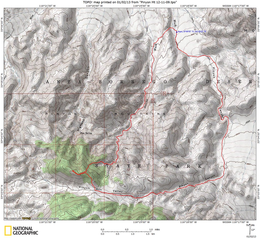
Nolina Wash
surfpontoAdministrator
|
We did a quick overnight trip to Anza Borrego to check out some areas we haven't visited.
First one is a bit funny. How many of you have stopped to check out the Well of Eight Echoes?
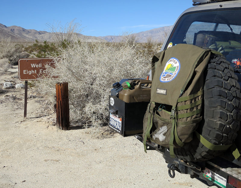

There are a couple conflicting stories on the origin of the well; one is that the pipe is what's left of a fountain head from a failed cotton growing venture in the 1920's, while others claim it was an attempt at drilling for oil.
We camped in the area to the north of Blair Valley and found a survey marker from 1954

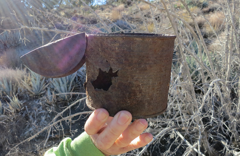
We also found this old makeshift kettle that looked pretty old. Both Mary and I commented that it was quite an ingenious idea.
There was also an interesting trail marked out with rocks that we couldn't quite figure out

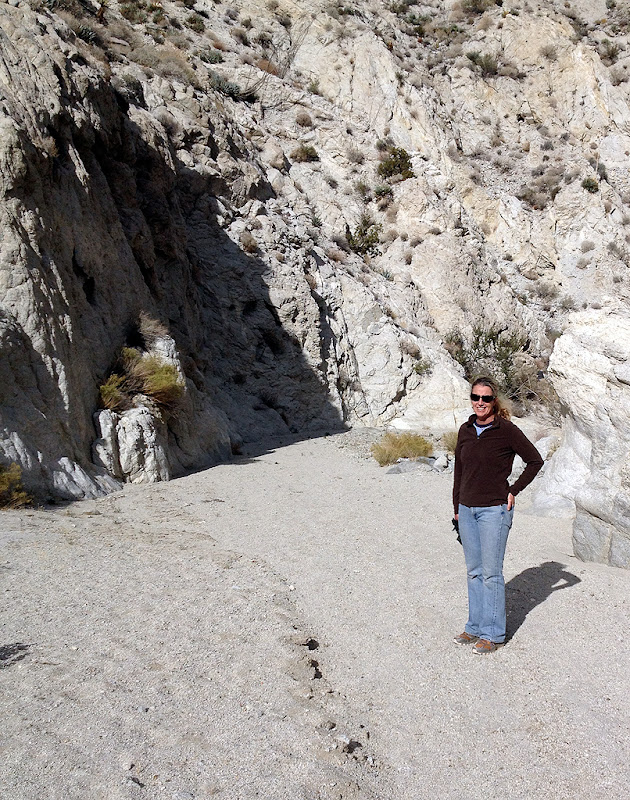
The next day we hiked up Nolina Canyon near Pinyon Wash which was awesome. Had not been in that area before and will definetly go back to do some more exploring.

edited by surfponto on 12/31/2012 |
12/31/2012
Topic:
Gray Mountain
surfpontoAdministrator
|
Great way to welcome in the New Year Nolan
Happy New Year
Nolan (anutami) wrote:
Ahhhh, sitting at the Indian hill trailhead wishing I could take photos that good. NICE SHOTS!!!!!!!! |
12/31/2012
Topic:
Gray Mountain
surfpontoAdministrator
|
I agree. Love the B&W shots, especially the Table Mountain arch.
That olla piece is great!
I would have thought the same thing seeing that |
12/31/2012
Topic:
Nolina Wash
surfpontoAdministrator
|
I gave it my best yell and got a semi echo
I guess back in the day it was a lot more impressive, hence the name
I am guessing it has been slowly filled up over the years.
rockhopper wrote:
Looked like a beautiful day. Last time a well of Eight echos was probably about 25 years ago.
I do remember yelling down it |
1/2/2013
Topic:
Agua Caliente Park
surfpontoAdministrator
|
That is great that they sell propane at the store. Never realized that.
Store looks pretty cool.
Guess I need to stop in there at some point
Bob
Nolan (anutami) wrote:
Thought I would piggy back on your thread and add photos of the Store. The guy that runs the place is way cool, and he has some pretty sweet stuff in there. I ended up running out of propane over the weekend and had to stop in and fill up! It is sweet that he sells propane!!!!! It is also sweet that he accepts debit/credit cards!
......
edited by anutami on 1/1/2013 |
1/2/2013
Topic:
Nolina Wash
surfpontoAdministrator
|
We didn't make it that far.
I may hike up that way again this coming Sunday.
How far back is the waterfall? We veered off the the left up a side canyon at one point.
Bob
tommy750 wrote:
Did you make it all the way up Nolina to Pinyon Mt.? There's a nice approximately 30ft dry fall somewhere back there that's really pretty. Tom
edited by surfponto on 1/2/2013 |
1/2/2013
Topic:
First Trips to ABDSP
surfpontoAdministrator
|
Oldest pics I could find were from the 1990s
Here is a goofy one I did somewhere in Mortero Wash

Notice lack of wind towers
edited by surfponto on 1/2/2013 |
1/2/2013
Topic:
Nolina Wash
surfpontoAdministrator
|
Now I remember that trip.
Funny it took me this long to get out there.
I may hike around there on Sunday to see if we can get further up.
Bob
hikerdmb wrote:
Nolina Wash is a great little canyon. Daren and I did a loop a couple years ago where we went up Bighorn Canyon and crossed over to Nolina and headed back down to our start. Here is the link to that trip with some great night photos from my buddy.
http://www.anzaborrego.net/anzaborrego/forum/topic61-backpacking-in-bighorn-canyon.aspx |
1/3/2013
Topic:
Goat Canyon Trestle and The Impossible Railroad
surfpontoAdministrator
|
Great compilation.
thanks for posting that...
Bob |
1/3/2013
Topic:
Goat Canyon Trestle and The Impossible Railroad
surfpontoAdministrator
|
Not sure you can embed an iframe with this forum software.
Of course you could always export to a jpg but then you lose the interactivity
I will look into it,
Bob
Casey Van Tieghem wrote:
This is a Google Map that I created that is a work in progress. Sorry for all the scribbled trails. But it outlines the train tracks for you, and eventually will have some
hiking paths that I have taken that make sense. Feel free to collaborate with me on this map, however I am not sure how that is done exactly. I have tried to open it up to everyone.
I think I can send you an invite via email, but I'm not sure what that will accomplish.
https://maps.google.com/maps/ms?msid=200894553877442534046.0004cd8885173c865ca28&msa=0&ll=32.727292,-116.184797&spn=0.047583,0.055275
Perhaps the admin could help me with the below html:
[html]<iframe width="640" height="480" frameborder="0" scrolling="no" marginheight="0" marginwidth="0" src="https://maps.google.com/maps/ms?msa=0&msid=200894553877442534046.0004cd8885173c865ca28&ie=UTF8&t=m&ll=32.7509,-116.180248&spn=0.069299,0.109863&z=13&output=embed"></iframe><br /><small>View <a href="https://maps.google.com/maps/ms?msa=0&msid=200894553877442534046.0004cd8885173c865ca28&ie=UTF8&t=m&ll=32.7509,-116.180248&spn=0.069299,0.109863&z=13&source=embed" style="color:#0000FF;text-align:left">Carrizo Gorge Railway Map</a> in a larger map</small>[/html]
edited by harmono on 12/28/2012
edited by harmono on 12/28/2012
edited by harmono on 12/28/2012 |
1/3/2013
Topic:
Nolina Wash
surfpontoAdministrator
|
It looks like an old marked foot path that kind of just disappears into the cholla.
It is definetly man made, I just don't know how old.
Jim (ziphius) wrote:
That looks like a fun trip Bob! The rock formation is very curious..... Jim |
1/3/2013
Topic:
Nolina Wash
surfpontoAdministrator
|
Thanks.
Looks like we have to go a bit further next time.
It is a great area.
tommy750 wrote:
surfponto wrote:
We didn't make it that far.
I may hike up that way again this coming Sunday.
How far back is the waterfall? We veered off the the left up a side canyon at one point.
Bob
tommy750 wrote:
Did you make it all the way up Nolina to Pinyon Mt.? There's a nice approximately 30ft dry fall somewhere back there that's really pretty. Tom
edited by surfponto on 1/2/2013
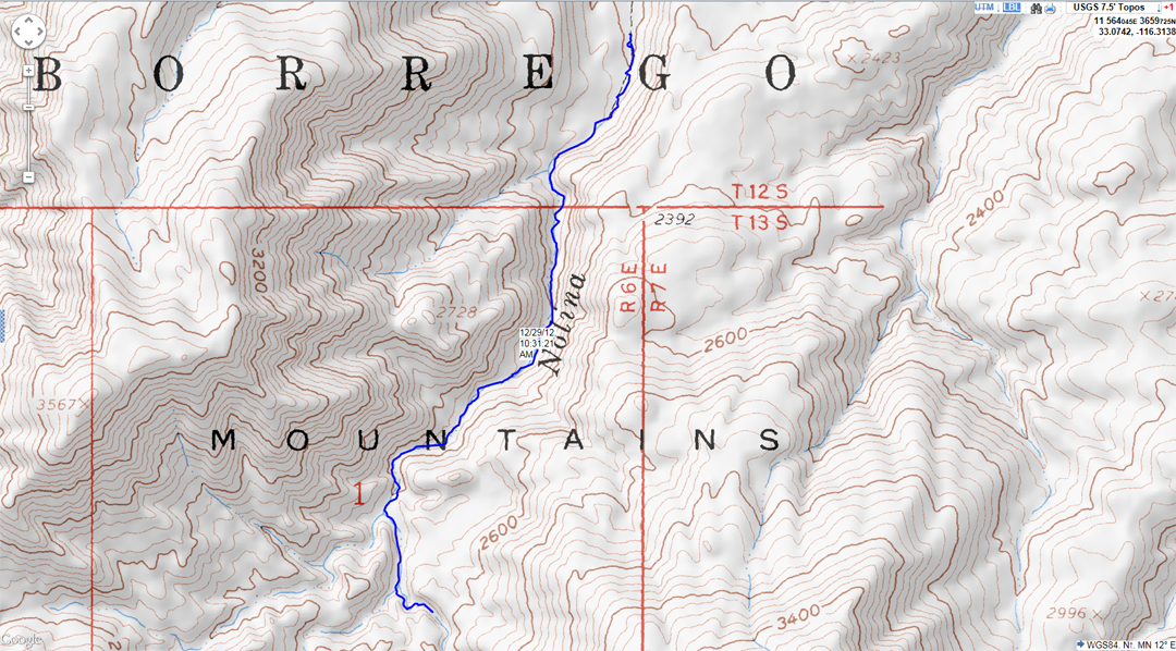
Not positive how far up it was but think you were getting close. Here's a map of my loop up Pinyon Wash and down Nolina. Was modified from a Schad hike. Think he described a Bighorn to Pinyon Mt to Nolina loop. Tom
Pinyon Mt by tomteske, on Flickr |
1/3/2013
Topic:
Nolina Wash
surfpontoAdministrator
|
It is one of those, "well ok let's just stop and check it out spots".
Pretty funny it has its' own marker and turnout
Nolan (anutami) wrote:
That's funny because we almost stopped by the Well, but another car was pulled over so I kept going....Never been |
1/3/2013
Topic:
Bald Eagle Nest
surfpontoAdministrator
|
That is great.
Awesome birds.
With regards to not being ABDSP related, that is why I added the "Our tribute to the beautiful Anza Borrego Desert
and the surrounding San Diego backcountry" line on the main site.
I figure there are a lot of great areas outside of the park that are worth discussing.
edited by surfponto on 1/3/2013 |
1/6/2013
Topic:
The Slot and The Wind Caves
surfpontoAdministrator
|
Spent the weekend exploring the Slot and the Wind Caves at Borrego Mountain.
Will post a short TR soon.
Here is a quick video of the Slot
Trip Report Is Here
edited by surfponto on 1/7/2013 |
1/7/2013
Topic:
The Slot and The Wind Caves
surfpontoAdministrator
|
Easy 2wd if you stay on the trail
We saw a 2wd Tundra get pretty buried while we were out there.
dsefcik wrote:
That looks pretty cool, is the road out there an easy 2wd or is it rough 4wd? |
1/7/2013
Topic:
7 Days in Anza Borrego Desert State Park
surfpontoAdministrator
|
Daren that is an awesome TR
The fossils are amazing!!
I would like to head out to Fish Creek sometime to check those out.
let me know when you are up for a mid-week trip?
Bob |
1/7/2013
Topic:
Pinyon Wash to Harper Flat and Cabin
surfpontoAdministrator
|
Good to see cabin is still there somewhat
Looks about the same as when we hiked to Harper Cabin with the Anza Borrego Foundation a few years back.
We commented the same thing about the wires over the dam.
 |
1/8/2013
Topic:
The Slot and The Wind Caves
surfpontoAdministrator
|
Nice pictures.
It is a fun area. I can imagine that your grandkids love it
Kind of like Indiana Jones
Bob
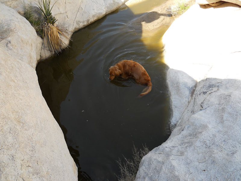
waning moon wrote:
It is very nice, my daughter took photos last time down, some look identical to yours. All I do is drive, drop them all off at the top and pick them up at the bottom, then drive North out Borrego Mtn. Wash. .....
....Another nice Family trip |
1/8/2013
Topic:
The Slot and The Wind Caves
surfpontoAdministrator
|
Thanks, music was from YouTube
We watched a couple jeeps go down the drop off.
Doesn't look too bad but my better half talked me out of it
Bob
hikerdmb wrote:
I like the music in your video. That is an unusual place for ABDSP. Looks more like Utah. I've been down that drop off a couple of times but never tried going up...that one, anyway. |
1/8/2013
Topic:
The Slot and The Wind Caves
surfpontoAdministrator
|
I was inspired after seeing your Goat Canyon MTB video
Nolan (anutami) wrote:
a picture is worth a thousand words, and a video is worth a thousands pictures. Nice! gotta check that place out |
1/8/2013
Topic:
Subject: A few Winter Blooms
surfpontoAdministrator
|
Yeah i have noticed some Winter blooms in the past couple weekends out there.
Really looking forward to Spring to see how the flower season goes this year.
Thanks for posting the pics
Bob
waning moon wrote:
Just missed the Cholla bloom
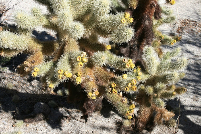
Chuparosa

Desert Lavender

My Favorite Ocatillo

Bloom
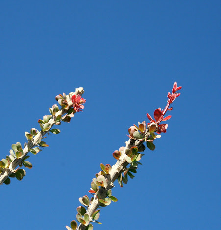
Yellow Chuparosa

Yucca Condo
 |
1/9/2013
Topic:
7 Days in Anza Borrego Desert State Park
surfpontoAdministrator
|
Funny,
I was thinking the same thing about the beard.
I am wondering how long it takes to grow a beard like that?
I have had mine since November and my wife is ready to shave it off while I am sleeping
Jim (ziphius) wrote:
dsefcik wrote:
Jim (ziphius) wrote:
Follow-up question: what are the sizes of the feline fossil prints? Regular 50-60lb dog size in the mud....I think the Remeika document has details of them. I think Joel humored me for the canteen photo as he hiked on and left me in the dust, he is tougher,smarter and in better shape than most people I know.
Daren, you ought to consider growing a huge beard so you fit in better with that backpacking crew. I'm envious that you get to spend time with such a knowledgeable and experienced desert gang. |
1/10/2013
Topic:
7 Days in Anza Borrego Desert State Park
surfpontoAdministrator
|
Maybe we could make this a separate topic but another way to manilulate the image sizes in Google - Picasa is to change a portion of the image url
See attach
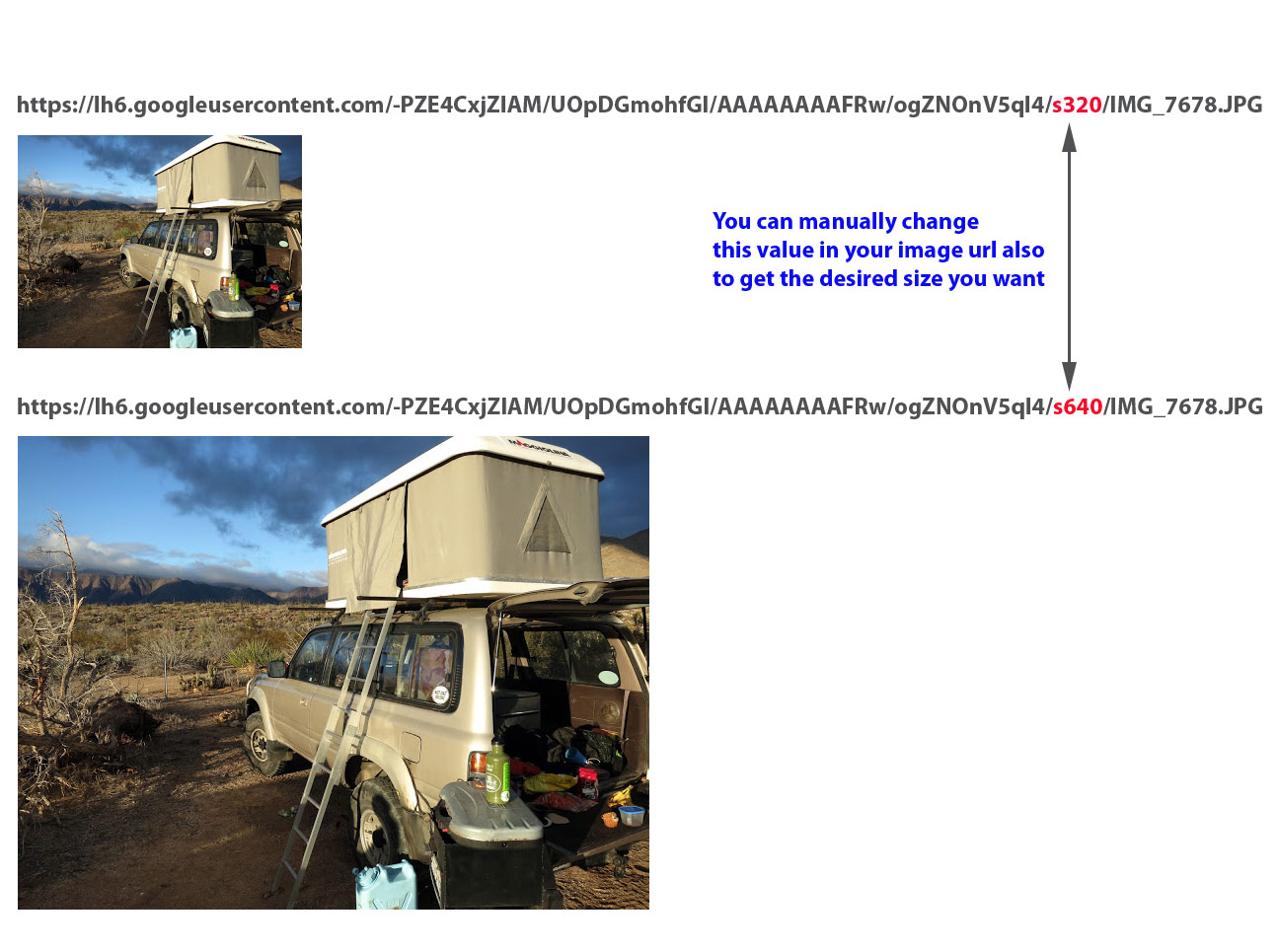
dsefcik wrote:
waning moon wrote:
but I am sorry to say after that, I click and drag to post. I do not know how to link? I have tried increasing pixels, resizing in google upload etc. (was successful once), but last post was small size again until I see Bob edited, (Thank you Bob) Yeah, Google kinda jacked up the simplicity of it..you could try clicking your image so it opens up bigger then *right* click and select the "copy image url" or similar and use that code.
edited by surfponto on 1/10/2013 |
1/10/2013
Topic:
Adding Images From Google - Picasa
surfpontoAdministrator
|
To link to an image that you have stored in your Google-Picasa album , follow these steps.
- Click on individual image in your photo album
- Select "Link To Photo" option on left (see image)
- Select desired size from "Select Size" drop down menu (see image)
- Check "Image only (no link)" check-box (see image)
- Copy text from "Embed image" text box and paste into image dialog box

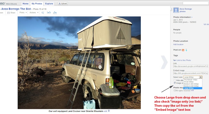
edited by surfponto on 1/10/2013
edited by surfponto on 1/10/2013
edited by surfponto on 1/10/2013 |
1/11/2013
Topic:
7 Days in Anza Borrego Desert State Park
surfpontoAdministrator
|
That is a good look on you.
Here's to leaving the office enviro 
dsefcik wrote:
Jim (ziphius) wrote:
Daren, you ought to consider growing a huge beard so you fit in better with that backpacking crew. I'm envious that you get to spend time with such a knowledgeable and experienced desert gang. How about this.....

I suspect once I leave the office enviro I will return to my roots. I am very grateful I am able to spend time hiking with the crowd I do. |
1/11/2013
Topic:
Indian Hill Carrizo Gorge Sunday Jan 13th
surfpontoAdministrator
|
Hi Casey,
I am guessing the foot paths were used to access the Carrizo Gorge tracks from the railroad camp area.
Casey Van Tieghem wrote:
Well my friend that I went to Goat Canyon Trestle with is talking about going out there maybe this weekend. My feet are still recovering, but maybe we can make it to Indian Hill.
I wanted to check out this hidden path that hopefully will take us to an overlook of Carrizo Gorge and take pictures there. So I'm thinking of setting off from Dos Cabesas Road near the Indian Hill wash, then walk across to the tracks. The only thing is this could be too long of a walk, and too hilly. So we probably will go to the end of Dos Cabesas like we did last time and not go to Indian Hill, but that would be a shame to go out there and not see Indian Hill. That's why it would be nice to have a mountain bike, so we can cover more ground in less time hopefully and with less strain on my feet. Anyways, we will probably play it by ear, but I most certainly want to try this hidden path that I have been talking about (see previous posts).
The hidden path is an alternate path to walking on all those trestles that lead to Goat Canyon Trestle. I have it outlined in this map. When they built the tracks they also cut out some foot paths from the hill, so potentially this would provide an alternate route, however I have reservations about going the whole way, because parts of the path I believe have been eroded, or rock slides have destroyed it. But I would be able to at least walk up the hill which is a more gentle slope than the surrounding hills, and possibly use this path a little to get to an overlook where I would be able to possibly see Goat Canyon Trestle and Carrizo Gorge from about 400-600 feet above the tracks.
https://maps.google.com/?ll=32.750323,-116.175613&spn=0.047571,0.055275&t=p&z=14 |
1/11/2013
Topic:
Adding Images From Google - Picasa
surfpontoAdministrator
|
Great,
Looking forward to your TR
herofix wrote:
Thanks for the tips, Bob. When I finally get around to posting my Thanksgiving hike, this will come in handy. |
1/12/2013
Topic:
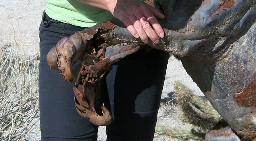
Carrizo Gorge Old Railway Train Parts
surfpontoAdministrator
|
I would like to hike in from that side also.
Let me know when you have tentative plans
dsefcik wrote:
Here is a Google Earth KML file of the trip. Great area, I want to go back and explore some more. |
1/14/2013
Topic:
Lower Myer Creek and Old Hwy 80
surfpontoAdministrator
|
That is a great post.
Like stepping back in time.
Like you said I have always thought of stopping and checking that out also.
Some great old artifacts
Bob |
1/14/2013
Topic:
Hurricane Kathleen 1976
surfpontoAdministrator
|
I left out one step which I think may be the problem with the pictures not showing up
You have to make sure the Google Picasa album is shared or not set to private
Will post screen shot in a bit,)
But the option you should select is "Public on the web"
Bob |
1/15/2013
Topic:
Baja Desert
surfpontoAdministrator
|
Sorry
Totally missed this post. We usually go down twice a year and really haven't had any problems.
The Grey Whales at San Ignacio were awesome and I will do that trip again.
The best time is late Winter to early Spring
Another option if you do not want to deal with he hassle of driving is to fly into La Paz and rent a car. I think there might also be a small airport at Guerro Negro
With regards to surf, I probably got some of the best waves of my life 2 years ago in Central Baja

Nolan (anutami) wrote:
Wow, I so miss it down there! Last trip was about 8 years ago on a surf/kayak trip to scorpion Bay (san juanico) and Bay of LA!...Since kids I just haven't mustered up the courage to take them down there. Bob, is it safe to go down there? The Gray Whales may change our mind in the near future! Does anyone know when the best time to go down and see them?
edited by anutami on 12/10/2012 |
1/16/2013
Topic:
Hurricane Kathleen 1976
surfpontoAdministrator
|
Hi again,
Are these hosted on Google Picasa?
Bob
waning moon wrote:
Well I beat these uploaded photos up enough trying to get the missing ones to post and also larger, ended up losing another in the process.
There was a post a while back which mention Hurricane Kathleen which came up the Gulf and inundated Ocatillo in 1976. I remember going down and my wife taking a number of photos, after rummaging through boxes they where found (in very poor condition). Photos were entirely brown a touch of purple, essentially sepia, I ran them through a scanner and corrected and then another program to enhance even more. Some came out, here are a few
West of old Millers


Looking SW up Devil's

Coyote Wells looking South towards Yuha Buttes

Looking West, Ocatillo in the background


Carrizo Wash from McCain's, I do not think this is Saccatone though, wash is clean cut

edited by waning moon on 1/15/2013
edited by waning moon on 1/15/2013
edited by waning moon on 1/15/2013 |
1/17/2013
Topic:
Baja Desert
surfpontoAdministrator
|
Tom, I would like to do that trip also
Nolan I know that spot
|
1/18/2013
Topic:
Hurricane Kathleen 1976
surfpontoAdministrator
|
Hi again
Was able to enlarge the pics on your original post. Some still show up missing but the majority are there.
They are great pictures!
Bob
waning moon wrote:
OK last try, the google program is not "Picasa", I venture into the WEB only as far as it suits my interests, do not trust it as far as I can throw it. Something, "Google Chrome" has been offered, but again I never upgrade or download, maybe that is where Picasa is? My Google album is public (cannot believe I did this but I have very good firewalls) still ABDF will not accept my copy and paste URL in attach files. So here goes another click and drag that was somewhat successful before.
Old Millers
Looking up Devils or as I see it now called Myers creek
Washout
Coyote Wells looking South to Yuha Buttes (when Coyote Wells was actually a place)
Railroad tracks
Railroad tracks with Ocatillo in the background
Carrizo Wash from McCains, clean cut from storm, I do not think this is Saccatone (this was before McCains was closed)
I happened to be to the top of San Pedro Matirs shortly after the Hurricane as well, huge pines (Jefferies) as large as Ponderosa's not like our drawf Laguna Mtn. Jefferries were pulled up as so many twigs and tossed around. At La Grulla the creeks were washed clean, 6" fingerling trout all that remained (and knowing that PETA and the Sierra Club will now be after me, I still ate them) no roads back then, 35 miles on a horse to the top in one day.
edited by waning moon on 1/17/2013 |
1/22/2013
Topic:
ACTIVE EAGLE NEST REMOVED TO MAKE WAY FOR WINDFARM
surfpontoAdministrator
|
Thanks for posting that.
Many people never hear about the dark side of these great new green technologies.
Very disturbing trend. I keep hoping wind farms will be exposed for the boondoggles they really are.
DRT Lakeside wrote:
http://www.eastcountymagazine.org/node/12258
Not ABDSP but related and could set some nasty precedents I would think.
As the article mentions, it is for the safety of the people and the eagles............Yeah right |
1/25/2013
Topic:
Modern day homesteader
surfpontoAdministrator
|
Probably retire pretty cheap that way
Nolan (anutami) wrote:
Check out the video link below. This will give you a good sense of what it would be like to live out in the desert in all those boulder caves. This particular family has lived among the boulders for 30 years and raised 7 children!
http://video.msnbc.msn.com/nbcnews.com/50549407#50549407 |
1/25/2013
Topic:
Favorite Photos from 2012
surfpontoAdministrator
|
Can't compete with some of the wildlife photos already posted but I kind of liked my butterflies in Box Canyon shot.
 |
1/25/2013
Topic:
Favorite Photos from 2012
surfpontoAdministrator
|
This one was actually 2013 but

edited by surfponto on 2/5/2013 |
1/28/2013
Topic:
Dos Cabezas Spring and vicinity
surfpontoAdministrator
|
Looks like you had a great trip.
Love that route up and over Mortero Palms and then down into Goat Canyon.
Haven't done that route in a few years now.
Did you guys actually get rained on? Looks like a lot of water in the morteros.
Bob |
1/28/2013
Topic:
Rebuilding the 1HZ Diesel Motor
surfpontoAdministrator
|
Well my main Borrego transport will be out of commission for about a month.
Hoping to have it up and running before flower season.
Doing a full engine rebuild out at my friend's shop in Ramona.

If you want to follow my rebuild check my BioCruiser Site
Bob |
1/28/2013
Topic:
Dos Cabezas Spring and vicinity
surfpontoAdministrator
|
It is nice hiking out there after a rain.
Looks like you had the place to yourself
Jim (ziphius) wrote:
surfponto wrote:
Looks like you had a great trip.
Love that route up and over Mortero Palms and then down into Goat Canyon.
Haven't done that route in a few years now.
Did you guys actually get rained on? Looks like a lot of water in the morteros.
Bob
Bob, we saw only sprinkles and arrived Saturday around 2pm. Judging by what I saw on the weather radar news images Friday, I think most of the rain fell that day. The old cement watering trough at the mouth of Mortero Palms Canyon had about 1/2 inch of water in it. There were numerous granite 'birdbaths' full of water almost everywhere we hiked. Dos Cabezas Rd. also had several large puddles. I joked that we didn't even need to bring water on our trip. |
1/29/2013
Topic:
Rebuilding the 1HZ Diesel Motor
surfpontoAdministrator
|
Thanks Jim,
Actually this started out as a injector pump rebuild since it had a small leak. Decided since we were pretty much pulling EVERYTHING off the motor to get to the pump we might as well rebuild the whole motor.
Pretty sure the motor doesn't need a rebuild since it is at 200,000 miles and these are the motors they use in the UN Toyota trucks overseas, designed to go for a long time.
At least I will get rid of some of the leaks
On a side note we ended up picking up one of these for a commuter car.
VW TDI (Diesel of course) 40 - 50 mpg hwy depending how you drive it

Bob
Jim (ziphius) wrote:
How many miles on that engine Bob? Rebuilding the engine is one of the greatest forms of recycling you can do. Most people throw in the towel and buy a new vehicle.
edited by surfponto on 1/29/2013
edited by surfponto on 1/29/2013 |
1/29/2013
Topic:
Favorite Photos from 2012
surfpontoAdministrator
|
That is really cool
You should frame it
Bob
tommy750 wrote:
Just found this in my truck. Could be the best fortune ever!
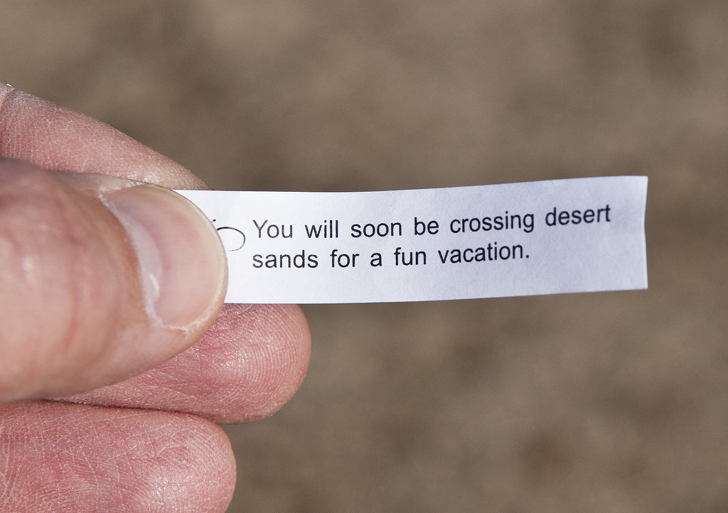
Desert Sands by tomteske, on Flickr |
1/29/2013
Topic:
First Trips To Baja
surfpontoAdministrator
|
Love that right point
Ahhh Baja
I will hunt up some pics.
We have a bunch from early college days....
Nolan (anutami) wrote:
Well, I had plans to be out in ABDSP this weekend but this crazy flu is taking its toll on our family. Went through some pics and found these
checkpoint, my dads nissan hardbody packed full,

Somewhere deep in baja

Fueling up

2nd point I think @ san juanico (scorpian bay)

edited by anutami on 1/26/2013 |
1/31/2013
Topic:
Favorite Photos from 2012
surfpontoAdministrator
|
Fixed
Think it is a bug with photobucket.
If I hit edit and save without making any changes the pictures show up.
Check now
Bob
dsefcik wrote:
How come the photos from desertwrx do not show up? All I see are links. |
2/1/2013
Topic:
Favorite Photos from 2012
surfpontoAdministrator
|
No problem.
I am looking into some sort of solution.
For now after you post , click edit and then save.
That seems to fix it
DesertWRX wrote:
Thanks for getting my photobucket pics working! |
2/1/2013
Topic:
Hurricane Kathleen 1976
surfpontoAdministrator
|
Hope you don't mind but I took the liberty of enlarging the photos.
Thanks for sharing them
Bob |
2/4/2013
Topic:
Borrego off trail camping
surfpontoAdministrator
|
I second Bow Willow.
Great hikes around the area and you are in the quieter end of the Anza Borrego Desert.
Welcome to the forum
Bob
DesertWRX wrote:
If you want to camp near bathrooms then Bow Willow, Arroyo Salado, and Fish Creek are good free campgrounds. If you have a 4wd, then there are hundreds (thousands?) of places to go near roads. mrkmc's post with the pdf is good.
edited by DesertWRX on 2/1/2013
edited by surfponto on 2/4/2013 |
2/5/2013
Topic:
Pacific Crest Trail
surfpontoAdministrator
|
That sounds like it will be quite an adventure Casey.
Have you driven a trailer with horses before?
You reminded me of a trip a year or so ago, where I had to tow these two guys from Texas out of the deep sand.
They had gotten their truck stuck trying to drive a horse trailer up Carrizo Gorge !
Bob
Casey Van Tieghem wrote:
My Sister asked me if I would be interested in driving for her when she rides her horses on the Pacific Crest Trail. She wasn't very specific about what her plans were, she just mentioned she will ride from the border to Campo on the first ride. But it looks like part of the trail goes through ABDSP. I apparently will be driving a truck with a horse trailer. I'm not sure where that will take me, but I'm trying to learn as much as I can about this, so I can plan some activities around this in advance. I found the mother lode of maps for this area in case you have not checked this out here's the link:
http://www.pctmap.net/download/p/mapdl.html
edited by surfponto on 2/5/2013
edited by surfponto on 2/5/2013 |
2/8/2013
Topic:
Presidents Day Weekend Backpack Anyone Interested?
surfpontoAdministrator
|
Hey Daren,
MIght be able to meet you for the day and hike out with you. Wouldn't mind doing the Inner Pasture hike.
I am working on my Land Cruiser rebuild for the next 3 or 4 weekends but could hike out part way with you.
Bob
dsefcik wrote:
Was going to try and do a 3-4 or maybe 5 day backpack trip somewhere next weekend, no definite plan yet. Some ideas I have are:
Rockhouse Cyn/Dawns Peak
Sawtooth Mtns/Inner Pasture/Canebrake
Mortero Palms/Carrizo Gorge
If anyone is interested in joining me for one of the above or something different let me know. |
2/8/2013
Topic:
Presidents Day Weekend Backpack Anyone Interested?
surfpontoAdministrator
|
Cool let me know
dsefcik wrote:
Bob, if I do something that starts with going out to IP I will let you know. I haven't made any solid plans yet but have a few ideas. |
2/8/2013
Topic:
Where's The Wind?
surfpontoAdministrator
|
Thanks Tommy,
Yeah I saw that. Have been following Parke's daily photos and videos on their FaceBook page
Thanks for posting
tommy750 wrote:
Disturbing story in the Imperial Valley Press regarding an assault on a photog documenting Ocotillo Wind:
http://www.ivpressonline.com/news/ivp-ocotillo-wind-express-manager-arrested-20130207,0,6598501.story
Also, check out a similar story in East County Magazine:
http://eastcountymagazine.org/node/12402 |
2/12/2013
Topic:
Storm Canyon view and Laguna Campground
surfpontoAdministrator
|
Love that view from high atop Mount Laguna down into the desert
I would have guessed it would have been crowded up there with all the snow.
What's the story on that?
I like that hike off the campground. |
2/13/2013
Topic:
Goat Canyon Trestle and The Impossible Railroad
surfpontoAdministrator
|
Wow. Not sure of my feelings on this
Nice to have it closed and somewhat obscure.
Guess there would be no more hikes thru the tunnels if the trains started running, unless you were willing to do this

tommy750 wrote:
Nice article in the UT about the railroad getting fixed. Four to five trains daily are anticipated if it gets repaired. Hope they eventually put a passenger car in the mix. Tom
http://www.utsandiego.com/news/2013/feb/11/tijuana-san-diego-railroad-tracks/ |
2/13/2013
Topic:
Botany Society Speaker Rick Halsey on CA Wildfires
surfpontoAdministrator
|

San Diego writer-photographer Richard W. Halsey will outline the threat of huge wildfires to California’s deserts in a talk March 11 to the Botany Society in Borrego Springs.
Halsey, director of the California Chaparral Institute, is a trained wild-land firefighter, and is the author of Fire, Chaparral and Survival in Southern California.
The book was judged the Best Nonfiction-Local Interest Book by the San Diego Book Awards Association.
His talk starts at 10 a.m. at the Anza-Borrego Desert State Park Visitor Center on Palm Canyon Drive in Borrego Springs.
The public is invited to the presentation, and there is no charge for admission.
edited by surfponto on 2/13/2013 |
2/14/2013
Topic:
Looking For a Ride
surfpontoAdministrator
|
I agreed to hike part of the way up to Villager tomorrow with Daren.
I have to be back in La Jolla by 5PM so I am not sure how far I will actually get before I turn around. |
2/16/2013
Topic:
Daren's Villager Peak Trek
surfpontoAdministrator
|
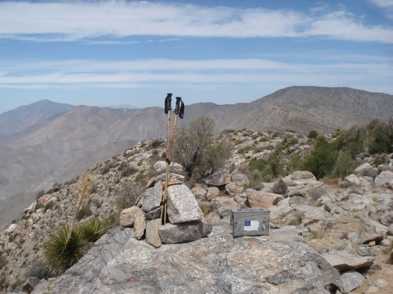
Hi All,
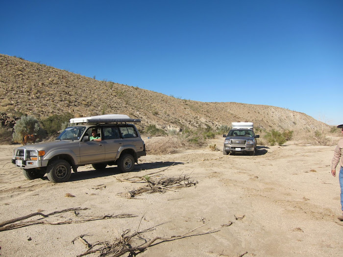
Hiked 3 hours in with Daren yesterday on the start of his 3 day backpack trip. I will say it involved some serious climbing :O
When I left him he was continuing on towards Villager Peak and hoping to find a nice area to camp.
Bob
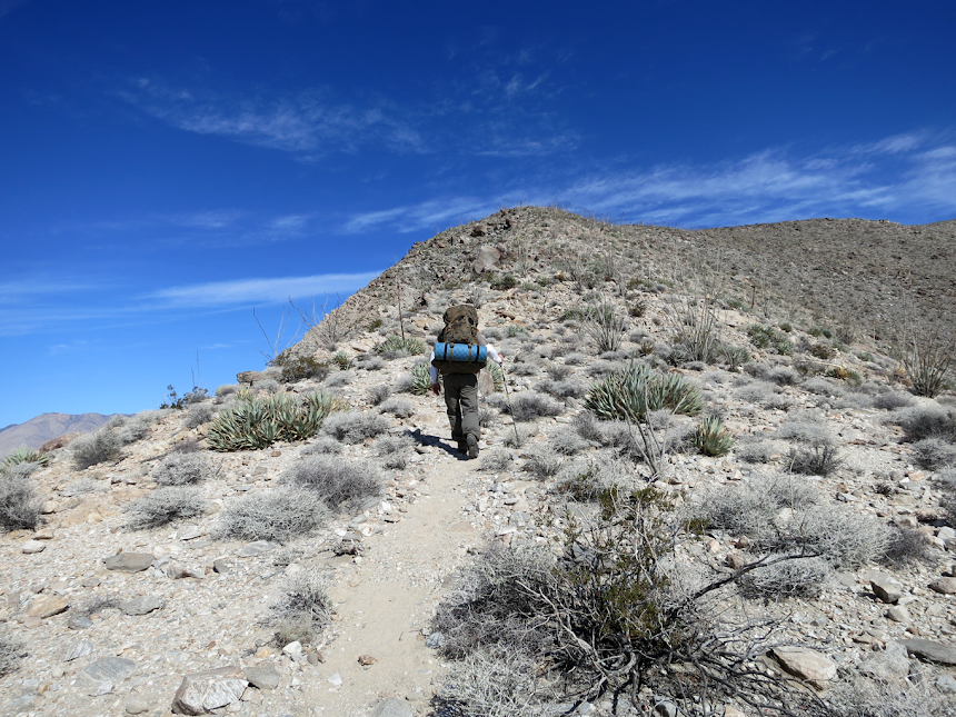
Felt guilty watching Daren lug his 70lb. pack while I had a day pack.

View of Clark Dry Lake far below
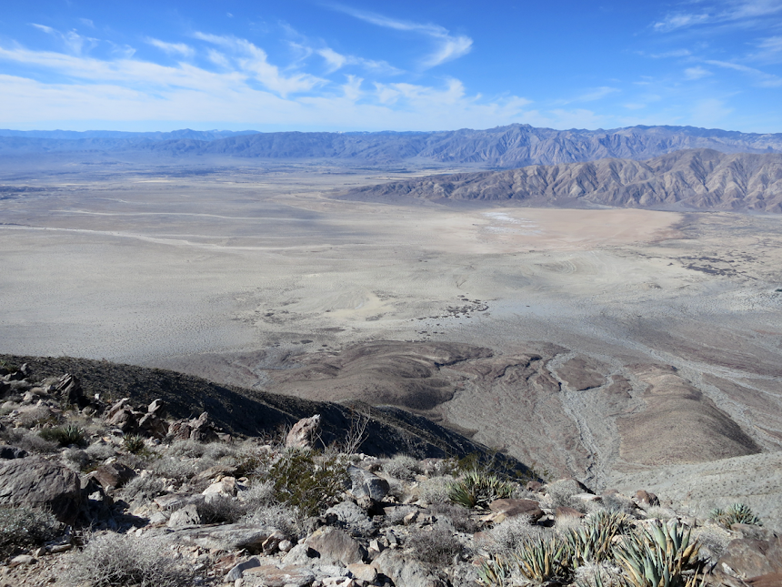
Spectacular views

We found these great sleeping shelters at the summit below Villager Peak

Daren contemplating if he should setup camp
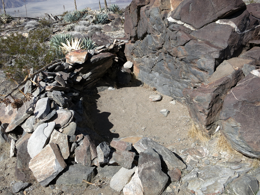
There was abundant pottery around this sleeping circle which led us to deduce it was used by Native Americans

Another view of Clark Dry Lake
edited by surfponto on 2/16/2013
edited by surfponto on 2/16/2013
edited by surfponto on 2/16/2013 |
2/18/2013
Topic:
Daren's Villager Peak Trek
surfpontoAdministrator
|
Thanks , I felt guilty for turning around when I did but he was well equipped
The trail is surprisingly well marked. The ducks made it really easy.
The view is absolutely amazing. I would like to go further in at some point.
Waiting to hear the rest of Daren's report also
rockhopper wrote:
Wow! 70# pack! How much water was Daren packing? If it was a dry hike, you ( I )would need about 3 gals. for 4 days and thats about 24 lbs. alone. Good news is that pack gets lighter and lighter as the hike progresses.That trail up Villager peak is one of the best in the county IMHO. Nice steady climb, well marked and outstanding views.
Going from Rabbit to Dawns peak is another story. I am sure Daren will have some great stories.
Bob, good show with helping Daren on his expedition loop trip.
The drop offs on the west side of the trail are awesome.
This is from last Mays Villager peak day hike.
Village peak
edited by rockhopper on 2/17/2013
edited by surfponto on 2/18/2013 |
2/18/2013
Topic:
Daren's Villager Peak Trek
surfpontoAdministrator
|
I met Daren off S22 since I was driving the TDI and the Land Cruiser is out of commission

Yep Ocotillo are looking very healthy Will be back out on March 9 so I am hoping to see some flowers
Nolan (anutami) wrote:
Nice!!!! I can't imagine doing that hike carrying my water in an olla :0
How was the road going into rockhouse? The ocotillo look like they are getting ready to "pop"
edited by anutami on 2/18/2013
edited by surfponto on 2/18/2013 |
2/19/2013
Topic:
SD mountains to get 18 inches of snow
surfpontoAdministrator
|
Look what's coming
http://www.utsandiego.com/news/2013/feb/17/alaskan-snow-san-diego-mountains/ |
2/19/2013
Topic:
SD mountains to get 18 inches of snow
surfpontoAdministrator
|
Might be time to head out and check David's (hikerdmb) water cachement near Indian Hill
rockhopper wrote:
Looks like ABDSP mountian water sources look promising for Feb./ March.
Martinez creek after Feb. rain/snow 1990's


edited by surfponto on 2/19/2013 |
2/19/2013
Topic:
Daren's Villager Peak Trek
surfpontoAdministrator
|
I am already planning to do an overnight at that great camp site we found
Mary is in.
dsefcik wrote:
Thanks for heading out with me for a few hours Bob, I made it to Rabbit right at sunset the first day. I was able to locate a water cache someone allowed to me use and grabbed 10 liters right below Villager so my total pack weight was probably close to 65lbs with all that water and the last ascent up to Rabbit was a bitch never mind the strong winds and cold air....working on a TR and will post soon! |
2/20/2013
Topic:
SD mountains to get 18 inches of snow
surfpontoAdministrator
|
David that shot of Carrizo Creek with all of the water is awesome |
2/20/2013
Topic:
Villager/Rabbit/Dawns Via Mojave & Rockhouse Cyn
surfpontoAdministrator
|
Hey Daren,
Yeah I felt a bit guilty leaving you up there Glad the trip went well.
Took me 2.5 hours to hike back down so you are right it was faster going downhill.
Awesome you found Jerry Schad's name in the registry as well as the petroglyphs.
Really adds the icing on the cake for your great trip.
Bob |
2/20/2013
Topic:
Anza Borrego Wildflower Season Preview - 2013
surfpontoAdministrator
|
Not really a wildflower report per say, but I added a preview of (hopefully) this year's wildflower season. These pics were taken over the last two years.
Not sure how well this works in Internet Explorer so let me know.
2013 Anza Borrego Wildflower Season Preview
Bob |
2/22/2013
Topic:
Anza Borrego Wildflower Season Preview - 2013
surfpontoAdministrator
|
Hi Kathy,
We have received plenty of rain, so from what I understand now if the temperatures warm-up in the next few weeks things will start to bloom.
We are heading out first week in March so I will post some pics
Welcome to the forum.
Bob
Kathy Fanning wrote:
Any predictions for what kind of year it's going to be overall? |
2/22/2013
Topic:
Villager/Rabbit/Dawns Via Mojave & Rockhouse Cyn
surfpontoAdministrator
|
Really puts your trek in perspective.
Serious climbing!!!
dsefcik wrote:
To follow up with the brush bypass and cliffed out route just in case anyone else is planning a similar route, here are some Google Earth images showing my route.
GE doesn't do justice to the thick brush but if you stay left on the ridgeline you will be staring at huge boulders and dense manzanita, here are two view angles of where I ended up going around a lot of it on the east side but doing that caused me considerable more elevation gain/loss


This is the finger ridge coming down from 6582, Schad's route is on the left of my track, I missed it and ended coming down right on top of this boulder cliff. I either had to climb back up and go around or try to maneuver horizontally across the boulders.....I chose the maneuver and it was a bit sketchy with the pack on....lesson learned, go down on the other ridge....

Close up of the boulder cliff and my horizontal tracks across it
 |
2/22/2013
Topic:
Circle of Art Art Show/Sale in Borrego Springs
surfpontoAdministrator
|
BASIC’s CIRCLE OF ART
The Secret is Out
Borrego Springs, “California’s Secret Desert”, will hold the 24th Annual
Circle of Art Show and Sale the third weekend in March. This FREE outdoor
juried art show will host over sixty artists exhibiting their quality works. These
will represent a variety of media including fine arts, oils and watercolors,
photography, sculpture, pottery, ceramics, jewelry, and fabric art. The artists will
create and display their work beginning Saturday, March 16, 2013 at 9 a.m. and
continue on Sunday, March 17 until 4 p.m.
Borrego Springs, the wild flower capital of California, is located in the middle of
Anza Borrego Desert State Park, the largest state park in the nation. This desert
oasis in east San Diego County is a destination for many visitors and is the only
certified “Dark Sky Community” in the state.
The sponsor of this event is BASIC, a 501c(3) organization which uses the
proceeds to fund educational scholarships for high school students and adults in
the Borrego Springs area.
This time of year people come from all over the world to enjoy Borrego’s
unspoiled natural beauty, awesome stargazing, vistas of wildflowers, and the
Circle of Art.
BASIC’s (Basic Assistance to Students in the Community) Circle of Art
Contact: Jacque Goodrich, P.O. Box 1914, Borrego Springs, CA 92004
Email: jacqgoodrich@ymail.com
Internet: www.circle-of-art.org
edited by surfponto on 2/22/2013
edited by surfponto on 2/22/2013 |
2/25/2013
Topic:
Villager/Rabbit/Dawns Via Mojave & Rockhouse Cyn
surfpontoAdministrator
|
Hey Daren,
That is the one I have.
Love the Canon S100. Also cool that it can do 1080p video.
Bob
dsefcik wrote:
Thanks Tom, I am currently looking at the Canon S100 but will also look into your recommendations.
TR wrote:
Daren,
Weight was a serious consideration when I swithed from my point and shoot Nikon, to a DSLR. From what I read one of the lightest weight cameras was the Olympus E-620. With a 14-42 mm lens it weighs just 28 oz. I also carry a 70-300 mm lens which weighs 25 oz. I've been really happy with it so far. I bought it reconditioned through Cameta Camera out on NY. I bought the 70-300 mm lens used on E-bay.
Tom |
2/25/2013
Topic:
Snow in the Anza Borrego Desert
surfpontoAdministrator
|
My friends that live out in Borrego Springs forwarded me this great photo of the recent snow they received.
This was taken off the Montezuma Grade
 |
2/25/2013
Topic:
Anza Borrego Wildflower Season Preview - 2013
surfpontoAdministrator
|
Thanks Nolan,
We are heading out this weekend to see how things are progressing.
Will be out Saturday and Sunday
Hoping to report back with some good flower pics.
Bob
Nolan (anutami) wrote:
Awesome!! You have some great photos. I think it is going to be a great flower season. Should start warming up soon |
2/25/2013
Topic:
Snow in the Anza Borrego Desert
surfpontoAdministrator
|
That is great also
Nolan (anutami) wrote:
Nice!!! I love seeing that sign!!!
Here is one from last year on Sunrise HWY
 |
2/25/2013
Topic:
Dawns Peak Via RHC/Mojave Valley
surfpontoAdministrator
|
I would say yes but our trip looks like a "visit the sculptures in Borrego Springs trip".
Bringing sister and some friends.
You are welcome to meet us Saturday night for a beverage though
dsefcik wrote:
Very tentatively planning a single over nighter to Dawns this weekend if weather and schedule work out. This will be a water caching trip for an upcoming hike thru over Spring Break. If anyone would like to join me and help carry some water, PM or email me. |
2/25/2013
Topic:
Anza Borrego Site Down
surfpontoAdministrator
|
Sorry
Main site and forum were down for about 3 hours today (4:30 - 7:15)
Configuration problem but all seems to be well now |
2/26/2013
Topic:
Anza Borrego Wildflower Season Preview - 2013
surfpontoAdministrator
|
Thanks for the update
Heading out Saturday to Borrego
Hoping to see some color
mrkmc wrote:
Was in western AZ this weekend and saw some brittlebush and chuparosas. Looked very green in general, but not many flowers yet. |
2/26/2013
Topic:
Villager/Rabbit/Dawns Via Mojave & Rockhouse Cyn
surfpontoAdministrator
|
Nice
Now you can show me how to use mine
dsefcik wrote:
I just ordered a new Canon S100 from Amazon so I will give that a try....7ozs vs 7lbs..... |
2/27/2013
Topic:
Villager/Rabbit/Dawns Via Mojave & Rockhouse Cyn
surfpontoAdministrator
|
Hey Rockhopper
I thinkI fixed your photo size issue.
Bob
rockhopper wrote:
........
All my nice full frame photos got all jacked up in the new and improved photobucket. Arrrrghhhh!
|
2/28/2013
Topic:
Diesel Prices and MPG
surfpontoAdministrator
|
I agree. I also need some sort of racks for our Mountain Bikes.
Nolan (anutami) wrote:
Bob, You need to get those windows tinted!
surfponto wrote:
I met Daren off S22 since I was driving the TDI and the Land Cruiser is out of commission
Yep Ocotillo are looking very healthy Will be back out on March 9 so I am hoping to see some flowers
Nolan (anutami) wrote:
Nice!!!! I can't imagine doing that hike carrying my water in an olla :0
How was the road going into rockhouse? The ocotillo look like they are getting ready to "pop"
edited by anutami on 2/18/2013
edited by surfponto on 2/18/2013 |
3/1/2013
Topic:
Diesel Prices and MPG
surfpontoAdministrator
|
Averaging close to 42mpg a tank combined freeway and stop and go.
I want to do a road trip to really see what it can do.
Apparently there is a couple who "hypermiled" their TDI for 1600 miles and got 84 mpg
Nolan (anutami) wrote:
I am about 12mpg diesel with a 3000 lb fully loaded camper and 7.3l 4x4.
dsefcik wrote:
Nolan (anutami) wrote:
By the way what did it cost you in gas to drive out to meet Daren? I spend approx $100 in diesel (or more) to get my rig out and back. About $50-$60 in my 2009 2500 Dodge Diesel CrewCab from Lemon Grove (current prices). I get about 16-18mpg and up to 22mpg on long distance freeway drives (Death Valley for example). |
3/1/2013
Topic:
Villager/Rabbit/Dawns Via Mojave & Rockhouse Cyn
surfpontoAdministrator
|
Hi again
I used the full photo link for the pics
I think it is under "Direct Link" in photobucket
Bob
rockhopper wrote:
Surf,
You fixed my photos! How did you do it??. What do I do to fix my "new" photobucket account. I should have left the old account alone! Sorry don't mean to hijack, but photos look soooooo much better. The snow on the Santa Rosas looks way better now!
A big THANKS
rockhopper |
3/4/2013
Topic:
Galleta Meadows
surfpontoAdministrator
|
We took my sister to see the "Creature Desert" at Galleta Meadows. Noticed some of the sculptures are deteriorating a bit. Curious as to how long they will last out there?
Galleta Meadows Slideshow. |
3/4/2013
Topic:
Galleta Meadows
surfpontoAdministrator
|
Good eye Daren. My friend lent it to me for the weekend.
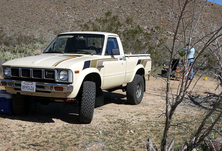
Fun to drive. Managed 21mpg for the weekend
dsefcik wrote:
I like the old Toyota truck....
edited by surfponto on 3/4/2013
edited by surfponto on 3/4/2013 |
3/4/2013
Topic:
Anza Borrego March 3rd Wild Flower Report
surfpontoAdministrator
|
Thanks for the update.
Here is what we saw this weekend
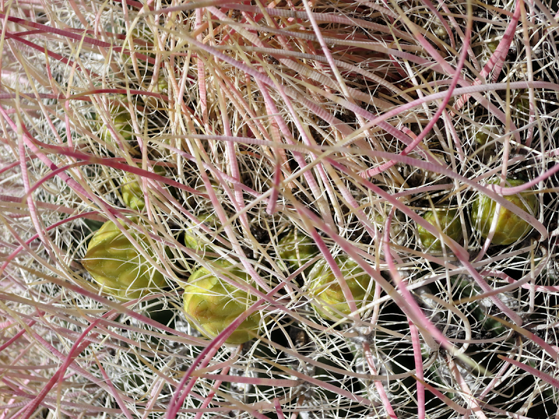
Barrel Cactus Buds

Barrel Cactus Buds
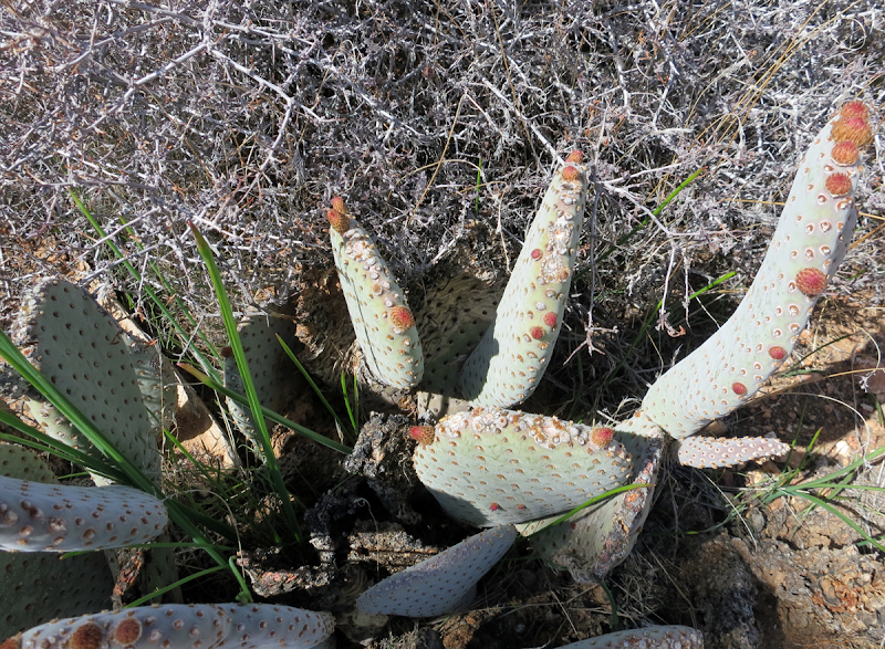
Beavertail/Prickly Pear Buds

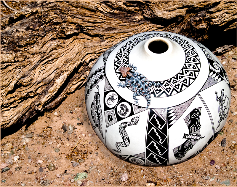
Fishook Blooms

Cool Portable Mortero

Old Mortero
I agree. At least a couple more weeks for flowers
edited by surfponto on 3/4/2013 |
3/4/2013
Topic:
Galleta Meadows
surfpontoAdministrator
|
No problem.
Hoping we can do another trip when the flowers start blooming
lindaally wrote:
Great weekend, Bob... It has been too long since I have seen a starry sky like that! Thanks so much for being our desert guide! |
3/4/2013
Topic:
Galleta Meadows
surfpontoAdministrator
|
I thought so too but look at a closeup of this pic
hikerdmb wrote:
You would think they would last a long time with how dry it is out there. That truck looks in pretty good shape.
edited by surfponto on 3/4/2013 |
3/4/2013
Topic:
Post your Anza Borrego Sunrise Photo
surfpontoAdministrator
|
I'll start.
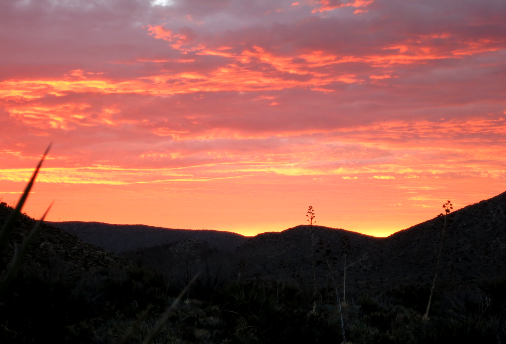
Amazing sunrise near Granite Mountain.
edited by surfponto on 3/4/2013 |
3/4/2013
Topic:
Galleta Meadows
surfpontoAdministrator
|
You are welcome
Welcome to the forum
desertminky wrote:
great pix Bob--thanks for showing us another part of your desert...look forward to the next trip |