1/3/2012
Topic:
Carrizo Canyon Road
mrkmc
|
Does anyone know how far you can drive down Carrizo Canyon from S2? (assuming high clearance 4x4 vehicle) On the topo map, the jeep road ends near the south end of section 24, but the State Park PDF map, and the Tom Harrison San Diego Back Country map give the impression that the road ends around the south end of section 13. In the satellite photo, it looks like the road is partially overgrown south of section 12.
Anyone been down there in the last year know how far it is drivable? Anyone have a waypoint for the end of the road? |
1/3/2012
Topic:
fire last summer in Anza B?
mrkmc
|
I was in the area in late October. Areas around San Ignacio on the Middle fork of Borrego Palm Canyon, upper end of cougar canyon and Sheep Canyons were burned. The worst seemed to be south of Sheep to Cougar, just east of the Indian reservation. Palm Mesa did not look burned. It was arson.
 |
1/4/2012
Topic:
Carrizo Canyon Road
mrkmc
|
dsefcik wrote:
OK, Cal Topo is cool, thanks!
Yes, Caltopo.com is my new favorite tool for planning routes! If only it would draw a profile and calculate elevation gain/loss I could get rid of Nat Geo Topo!
Thanks for the info. Looks like I can get about a mile further than I thought. I've been working out an idea for an all day cross country extravaganza in that area. I need to wait a month or 2 for a little more day light before I give it a try. |
1/7/2012
Topic:
New Years Trip-Scratching the Surface
mrkmc
|
I saw the dead hawk on 12-31-11 when I was hiking Sombrero. It looked like it had been there a while. Mostly just feathers. |
1/9/2012
Topic:
McCain Valley
mrkmc
|
I was in the McCain Valley area yesterday and got to see the towers that have been installed. The road is in excellent condition. It looks like the contractor has graded it nice and smooth. You could easily drive the road in a small car. (at least to the desert over look)
 |
1/9/2012
Topic:
Eureka, I have found it!
mrkmc
|
Nice shot of the moon! Looks like a fun day. |
1/16/2012
Topic:
Hidden gem Lycium Wash
mrkmc
|
Looks like a fun day. I bet your son had fun exploring all the rocks. I went up Oyster Shell Wash a few weeks ago and also saw a lot of scat. There was some ponded water in that canyon. |
1/26/2012
Topic:
Round Mountain
mrkmc
|
Nice! I always look at that peak anytime I drive out the 8. I want to visit it someday and also the Squaw Tit on the other side of the freeway. |
1/30/2012
Topic:
Mortero Wash, Indian Hill, Dolmite Mine, Jojob
mrkmc
|
What a great trip. Looks like you wore the kids out! |
1/31/2012
Topic:
Sombrero Peak
mrkmc
|
I was there a few weeks ago. There are use trails and ducks everywhere. Never encountered an area that was overly brushy. You will be fine. |
2/3/2012
Topic:
Cougar Canyon Conditions?
mrkmc
|
This trip report is from a few weeks ago. He has a video of water flowing somewhere in Cougar Canyon. I was in Sheep last weekend. There is water about half a mile up the canyon from the campground. Have fun! |
2/9/2012
Topic:
San Felipe Valley Wildlife Area
mrkmc
|
Never been there but driven by many times and rarely see anyone parked at the trailhead. Usually in the fall, during deer season there will be a few cars there. I have wanted to check out the Cigarette Hills area but its in the closed section. Let us know what you see! |
2/19/2012
Topic:
Anza Borrego Wildflower Report ?
mrkmc
|
I was anywhere from the 900'-4500' elevation in the Borrego Palm Canyon area on Saturday and only saw a few flowers. Things were looking slightly greener than they were a few weeks ago though. |
2/27/2012
Topic:
Moan, Puff, Groan and Gasp
mrkmc
|
I found this website and forum while looking for information about the Carrizo Creek jeep trail. I was planning a hike in the area and wanted to use the road as an exit point. After receiving some good information from people on this forum, I finally got a around to giving the route a try this weekend. We started up the jeep trail a little after 5:30AM and left a 4x4 at the end road. We then took my truck back out to the highway then drove over to Dos Cabezas Road via Mortero Wash. Six of us set off for Indian Hill at about 7:40AM. After a quick visit to the highpoint of Indian Hill we headed for Moan benchmark. The scramble up the east slope was a lot of fun and some of the boulders have interesting shapes and features.

Boulder near Moan BM
After a short break at the Moan benchmark we headed south, passing bump 3053 on the west. About a mile later we started traversing a steep slope, descending slightly until we were just below the Puff benchmark. The slope was loose, steep and covered in cactus. As we worked our way through this tedious section I could hear the others cursing the cactus. While enjoying the views of the railroad trestles from Puff a military helicopter came flying down the gorge a few hundred feet above the railroad.

Trestle from Puff BM

Helicopter from Puff BM
From Puff we descended the west ridge down to the gorge. Coming down the ridge we got a good look at the slope we would need to climb to reach Groan benchmark. There is a tricky section along the ridge were a steep back cut was made for an access road. Once we down climbed the road cut, we continued down the cactus covered ridge to the bottom of the gorge where we rested in the shade of a large boulder and picked the cactus needles from our skin.
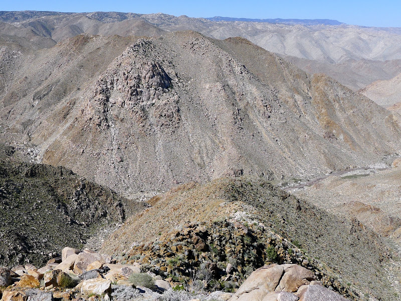
Looking across the gorge from the Puff Ridge at Groan

Looking up toward Groan from Carizzo Gorge
We forced our way across the brushy canyon bottom and started the steep climb to Groan. We climbed about 1200' in just over half a mile to reach the ridge! The area to the right of the giant rock out cropping was in the shade so we scrambled up the boulders and slabs at the base of the out cropping rather than slog up the slope in the sun. It took about 1.5 hours to reach the saddle, where we got another great view of the Goat Canyon trestle.

Goat Canyon Trestle with the Puff Ridge on the left from saddle near Groan BM
After regrouping at the saddle we walked over to the benchmark and took another break. By this point everyone had shed some bled. The cacti in this area are large and healthy! 2 people in the group had enough of the constant stabbings and decided to head off the north west ridge of Groan and follow the drainage to the vehicle at the end of the jeep trail. The rest of us dropped down to the saddle south west of Groan then began a gradual descending traverse to the drainage below the east ridge of Gasp. The climb up to Gasp benchmark was tough and required about 1400' of gain, but at least the north side of the ridge was in the shade. We were disappointed when we got to bump 2993, thinking it was Gasp. From there we had to give up a few hundred feet before continuing up the ridge towards Gasp.

Gasp as seen from bump 2993
It was a little after 4pm when we reached Gasp. By this point everyone was getting tired and a few of us were low on water and food. The original plan was to include the Grunt benchmark in the hike but we had enough for the day and decided follow the north ridge down to Carrizo Canyon. The ridge descent wasn't that bad because the sun had fallen behind the mountains and there was a nice cool wind. After dropping off the ridge we came across a use trail in the canyon bottom which we followed a short distance back to the waiting vehicle. With 6 people crammed into a small Suzuki 4x4, we headed for the highway and back to Dos Cabezas to retrieve the other cars. I want to give this hike another try, but skip Indian Hill and start an hour or so earlier. I think that would make adding Grunt a little easier.
Here are more pictures from the hike.
<em>edited by mrkmc on 2/28/2012</em> |
2/28/2012
Topic:
Moan, Puff, Groan and Gasp
mrkmc
|
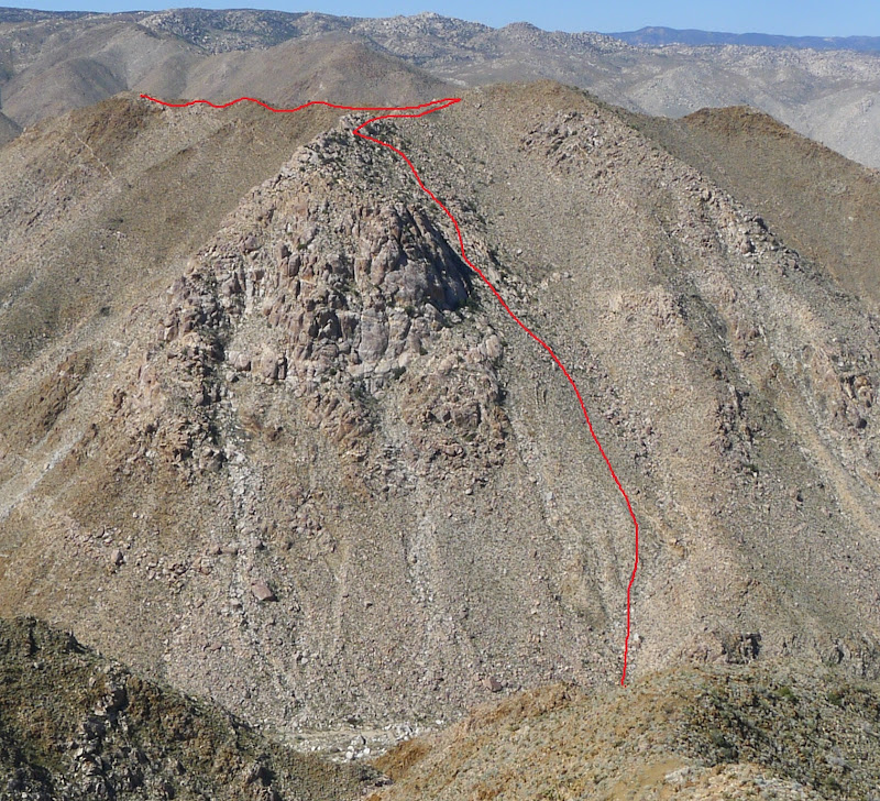
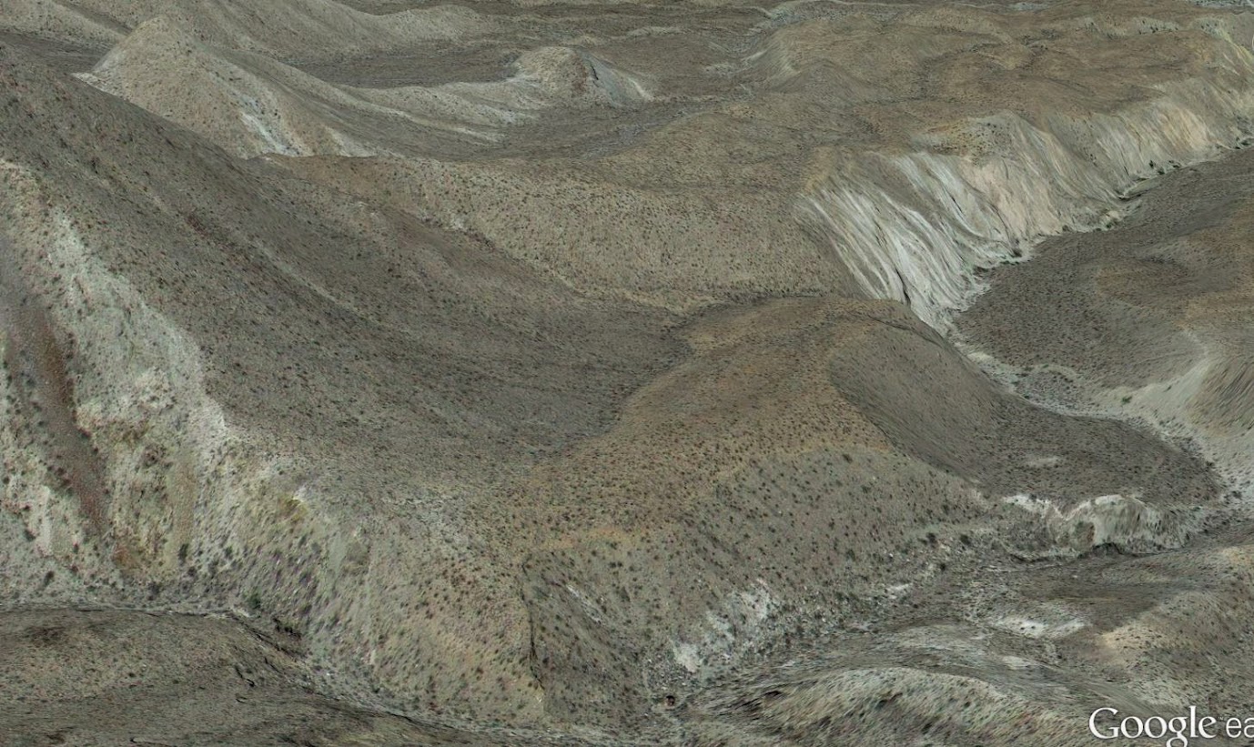
Bob, those old shovels were neat. I like how bent they were. I cant imagine how hard it must have been to be shoveling rock on the side of the canyon wall in the heat of summer! Daren, yes, going up Groan was tough. I considered climbing the slope directly below Groan. It looks a little better than the way we went, but getting there would mean traveling about 3/4 of a mile through the catclaw choked canyon. No thanks! The approximate route is drawn on the pic below. Thanks anutami, not really a finale, the park is so big I dont think you can every really be done exploring it. 
 |
2/28/2012
Topic:
Moan, Puff, Groan and Gasp
mrkmc
|
Also, here is a video clip of the helicopter flying through the canyon. We saw the same helicopter at the end of the day flying back up the canyon. |
2/28/2012
Topic:
ABDSP Via Sunrise HWY
mrkmc
|
I have walked down the road across from the ranch. I hiked out to Oriflamme Mountain and the Roost benchmark from there. I saw a camper back there. Looked like the person was living there. Uncle Rico? I think its in the state park. The PCT crosses the dirt road about 3/4 of mile from the gate. Great pictures of the fresh snow! |
3/21/2012
Topic:
San Felipe Valley / Plum Canyon / Yaqui Well
mrkmc
|
herofix wrote:
I now realize that the "short hike to a viewpoint overlooking Earthquake Valley" may have been at the end of the *left* fork. I swear I must have hiked 2+ miles (my definition of a "short hike") and didn't find any such viewpoint. Anybody know for sure? I
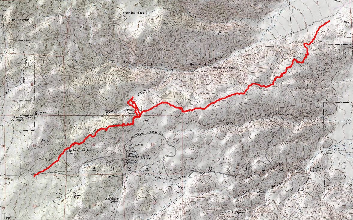
I believe you were on the correct trail. I hiked to Sentenac Mountain a few months ago from the west fork of Plum Canyon. I started from the end of the right fork (looks like what you have in your picture) and followed the trail/wash. I left the trail and headed directly for Sentenac, but the trail continued on toward the saddle. See this map, the black line is the approx trail, red line is where I went. It was only 1.25 miles to Sentenac, so its only about 1 mile to the view point.
<em>edited by mrkmc on 3/21/2012</em> |
3/22/2012
Topic:
San Felipe Valley / Plum Canyon / Yaqui Well
mrkmc
|
What Darren said. I didn't have my gps the day I did that hike, but you can estimate mileage and gain using National geographic Topo! or for free you can use caltopo.com (including the map posted above) you can right click on the map and select measure, then distance. Keep clicking along a line from start to finish and it will tell you the total mileage. |
3/23/2012
Topic:
Mortero Palms
mrkmc
|
Anyone ever seen this in person? Looks interesting.
 |
4/3/2012
Topic:
Carrizo Gorge / Mason Valley / Red Hill
mrkmc
|
ndians definitely favored Mason Valley, there are some great morteros in some interesting rock
Those are interesting. I have never seen them in that type of rock. Great pictures! |
4/8/2012
Topic:
Indian Valley / June Wash / Diablo BM
mrkmc
|
dsefcik wrote:
***mrkmc*** looks like I am just following your trail lately
Diablo was a fun hike. A military jet screamed past as we walked up Sandstone Canyon. I saw https://picasaweb.google.com/112918892253657164707/VallecitoMountainsHighpointDiabloBenchmarkAndSplitMountainWest#5687693483869747058" target="_blank" rel="nofollow">this business card in the register and later found a great story in Desert Magazine (see page 4) about the park superintendent and Leo exploring Sandstone Canyon for the first time. I imagine the card was left in the register around that time.
Great pictures as always, I really like the picto guy with the arms and hands. |
4/16/2012
Topic:
coachwhip canyon and Palm Wash
mrkmc
|
Looks like fun! I want to check out that area you have in the pic of the map. There are some benchmarks of there I want to hike to. |
4/16/2012
Topic:
Exploring The Island and Myer Valley
mrkmc
|
Another area I still need to check out. There are 3 benchmarks "on the island" that I want to check out, Devil, Inko, and Pah |
4/17/2012
Topic:
Exploring The Island and Myer Valley
mrkmc
|
dsefcik wrote:
What map do you see those on? My USGS topos only show 7 unamed BM's.
They are not on the map. You can find a list of all the stations for each quad using the ngs website. (for some reason I cant link to the list generated or the data sheets) But follow the links on that site: Survey Marker Data Sheets> Data Sheets> USGS Quad> then enter In-Ko-Pah Gorge. Once you get to the list, you can select the station you want and tget the data sheet, which gives a writen description on how to locate the BM.
<em>edited by mrkmc on 4/17/2012</em> |
4/18/2012
Topic:
Guillermo Pino Still Missing Assistance Requested
mrkmc
|
Official Search Suspended |
5/6/2012
Topic:
Body Believed To Be Missing Hiker Found
mrkmc
|
Sad. Sounds weird to say but I hope he died from the fall into the hole and wasn't stuck in there for days. |
6/20/2012
Topic:
Lower Willows Trail
mrkmc
|
I saw this guy in the spring. I think he had just came out of his hiding spot in the sand:
 |
6/26/2012
Topic:
Squaw Tit and Table Mountain
mrkmc
|
not that I like the power lines but that picture is awesome! Thanks for the trip report. |
7/19/2012
Topic:
Older Anza Borrego maps
mrkmc
|
Interesting. On the current usgs map, the s22 is shown as under construction east of Ranchita. The under construction route varies from the current alignment. as it nears Borrego Springs. I never realized this until I was hiking to the Hans Benchmark from s22. It took me a while to figure out I wasn't standing at the bend in the road shown just above the Hans BM on the topo, but was further up the ridge where there is no road shown on the map. |
7/24/2012
Topic:
Fish Creek Wash Rd Conditions
mrkmc
|
much easier road than carrizo and rockhouse. |
8/2/2012
Topic:
Looking for tinajas on San Clemente Island
mrkmc
|
Neat trip. I would love to be able to explore that island. Thanks for sharing. |
8/16/2012
Topic:
Storm Canyon / Vallecito
mrkmc
|

I saw this one last time I was in that area. Is the man with the crossed legs around there? |
8/16/2012
Topic:
Storm Canyon / Vallecito
mrkmc
|
Would be a great place for a backpack and its BLM, but I think the typical trail head is state park, and day use only. I guess you could park on the highway and walk in for an overnight trip. I got my eye on peak 3902 for this coming season. (I dont head out in triple digits like you brave souls ) |
8/21/2012
Topic:
Storm Canyon / Vallecito
mrkmc
|
Nothing special about that peak. When I was looking at the map last time I went to that area I noticed it had a over 900' of prominence. Then I saw it was on peakbagger.com, so I have wanted to hike up there since. I have several random, remote peaks I want to check out this winter. I will let you know, maybe we can meetup for a hike. |
8/23/2012
Topic:
Best Scat Finds
mrkmc
|
holy ****! |
8/23/2012
Topic:
The Destruction of Ocotillo Ca
mrkmc
|
Several of those pictures (#'s 88-102) appear to be of an existing materials facility that has been there for years. |
10/20/2012
Topic:
Squaw Tit, Table Mountain and 10 other Benchmarks
mrkmc
|
Did some hiking/ driving in the desert this weekend. First stop was in the Jacumba area to several benchmarks, Squaw Tit and Table Mountain. Fairly uneventful other than a run in with the boarder patrol. I was on my was to the Puto Benchmark, which happens to be a few hundred feet from where the border fence comes to an end. I was about 50' below the benchmark when an agent drove up. I pretended I didn't see him and just kept hiking up. I was nearly to the BM when he summoned me on the loud speaker to "please come down here so I can talk to you" I knew I had every right to be in the area, it is BLM. I was pretty sure he was just going to give me the speech about how dangerous the area is. I was only about 1 minute from reaching the BM so I yelled down to him that "I was just out hiking and I was going to continue onto the BM then come down". I turned my back and continued up. A few seconds later he came back on the loud speaker and asked me to come down. It didn't really sound like and order, so I kept heading up and found the BM. I made sure I stayed in view of him so he wouldn't think I was running away, took a pic of the BM, took a pic him by my truck then started down. Took me about 5 minutes to get back down, where he walked over and met me at the base of the hill. He asked what I was doing and I explained. Surprisingly he didn't scold me for continuing up after he told me to come down. As I suspected he was just checking to see what I was doing so close to the border, and especially right where the fence comes to and end. He told me how dangerous it was around there and I shouldn't be there. I told him I planned to hike to several more BM's in the area that day and appreciated that he was paying attention. So after hiking/ driving to Jade, Puto, Tahe, Gold and Nopal, I drove over to Mica Gem Road and crossed under the I-8. I hiked up to Squaw Tit and Table Mountain. This is a nice area and I like the red rocks and soils. After that I headed in to ABDSP and found a spot to camp, made dinner, took a few pictures and went to bed.
The next morning I got up at sunrise to start hiking to several Benchmarks in the Blair Valley area. First up was Rego Benchmark. This is a great little "peak" with good views of Blair Valley and Granite Mountain. The summit area and northeast slope looked to be recently burned. After Rego, I headed off for Seyer and Box BM's. The area just above Box Canyon next to the highway was also recently burned. I was quite surprised to find the survey tower at the Seyer BM still fully intact. I usually just find pieces of wire and wood all around but this one was still standing. I traversed over to Box BM, found the register then dropped down into Box Canyon. I found the skull of something. Maybe a Coyote, I am not sure. Also saw a bee hive in a hole in the canyon wall. Next up was Quake and Shake BM's over in Blair Valley. Nothing to exciting here, but the area was deserted. Didn't really see many people out at all this weekend, except for the 20+ cars belonging to hunters I saw parked along San Felipe Road.
All of the pictures can be seen on my picasa page.
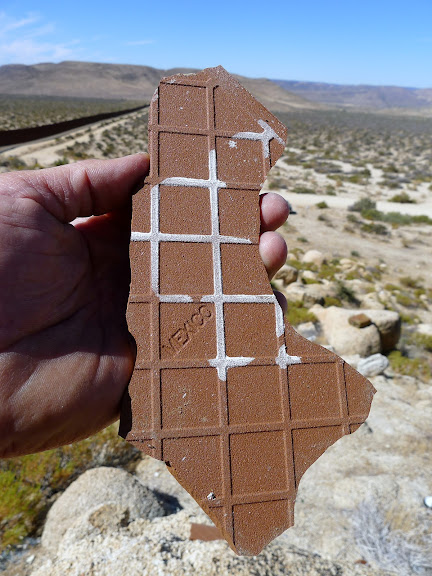
The Indians in Mexico made much more advanced pottery than those in CA


Note the Boarder Patrol behind my truck
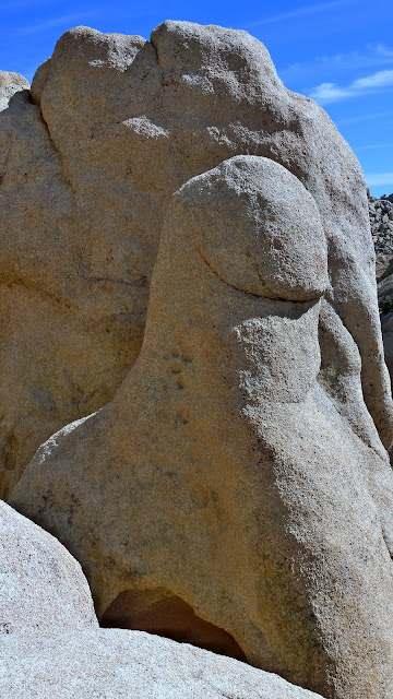
Man Yoni?

Seyer BM survey tower

skull. coyote? The jaw and top were not connected, I may not have put it together right?
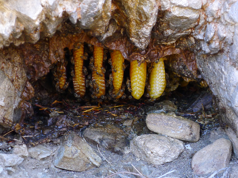
Bees!
<em>edited by mrkmc on 10/20/2012</em> |
10/22/2012
Topic:
Squaw Tit, Table Mountain and 10 other Benchmarks
mrkmc
|
tommy750 wrote:
the long glorious tradition of obscene and offensive place names in official maps.
I like looking at the old topo maps on caltopo for obscene and offensive place names. There are several in southern California that are no longer used.
ziphius wrote:
It looks like 1941 was a popular year to install benchmarks. Is there any rhyme or reason to which ones are missing the elevation stamps?
Yes, lots of the BM's in the area are from the early 40's. Seems like most don't have the elevation stamped on, but its almost always shown as a spot elevation on the topo. Several of the ones in my pictures are the locator markers (the ones with arrows) There was one on Gold, but I forgot to take a picture of it. Didn't find one on Tahe or Nopal. The summit area of Tahe looked to have been bulldozed or graded, maybe associated with the Eliot mine. |
10/23/2012
Topic:
Fish Creek Wash Rd Conditions
mrkmc
|
DesertZenGlen wrote:
I want to see how things are going on getting all the paint off of Oyster Shell Wash
What do you mean by get all the paint off of Oyster Shell wash? |
10/24/2012
Topic:
Squaw Tit, Table Mountain and 10 other Benchmarks
mrkmc
|
BorregoWrangler wrote:
Did you happen to see any quail out there?..........
I would have done the same as you when the Border Patrol agent called,...........
Didn't notice any quail. I don't mind the BP stopping to check me out. I was right by the end of the fence, with a truck and a backpack...Its good to know they are paying attention. What bothers me is when they give the Impresion or try and intimidate people into thinking they are doing something wrong. I have had several encounters with them and they all try and make you leave the area, without directly coming out and saying it. They always make it sound like a war zone. I think the more legal people they deter from the area the easier their job is. |
10/29/2012
Topic:
Rockhouse Canyon 4 Day Backpack TR
mrkmc
|
Great trip report! I only drove to the end of RHC one time when my daughter was only 3 months old. My wife held her head so it wouldn't bounce around so much. She slept through the whole drive! Seems most of the BM's in ABDSP have registers. There are a handfull of them in the Clark Lake area I hope to check out one of these days. |
11/5/2012
Topic:
GPS map of the Anza-Borrego Desert
mrkmc
|
I agree with Darren. Why use that map when you use something like back country navigator. Even without a gps, the Tom Harrison map of the San Diego back country has more detail and info. |
11/13/2012
Topic:
Pinto Wash Petroglyphs
mrkmc
|
Wow! What is one supposed to do if they find human bones in the desert? Let it be and forget about it, or do you report it to authorities? For that area its likley from someone crossing the border, but how do you know its not from foul play? |
12/4/2012
Topic:
Little Petroglyph Canyon (AKA Renegade Canyon)
mrkmc
|
I did that drip a few years ago. It is a special place and worth the visit. Great pics! |
12/19/2012
Topic:
Looking for a place to camp/sleep with electricity
mrkmc
|
We went to Yellowstone for a week on a family vacation and someone in my family used one of those machines. They brought this battery pack that was enough to run the cpap all night in the tent. They recharged it during the day with an ac inverter and also using the power in the restroom at the campground. The battery pack would be way better as you could camp anywhere in the park rather than being limited to regular campgrounds. |
12/21/2012
Topic:
Dos Cabezas advice
mrkmc
|
I would take the blue route if driving in a car |
12/21/2012
Topic:
Desert Renewable Energy Conservation Plan-Article
mrkmc
|
dsefcik wrote:
I know the school I work for has been installing rooftop solar for the last few years and recently a solar powered vehicle re-charging station. They claim a significant reduction in electricity bills.
Didn't come from the desert, came from our rooftop.
Those school rooftop solar projects are paid for with obama cash. They will never pay for themselves with money saved on electricity bills. |
12/23/2012
Topic:
Desert Renewable Energy Conservation Plan-Article
mrkmc
|
Darren, I am willing to bet it was some kind or federal grant or rebate. When I say Obama, I just mean federal government.
The solar and wind thing is a big joke. it takes up so much space and is so inefficient. San Onfore generates power for 1.5 million homes, Ocitillo wind farm, 125,000. WTF? |
12/23/2012
Topic:
Davies Valley and Pinto Canyon
mrkmc
|
Is that gate ever open or is the area only accessible by foot? |
12/30/2012
Topic:
First Trips to ABDSP
mrkmc
|
Great pictures. I really like the pumpkin patch pic. The helmet looks like one of the pumkins.  |
1/28/2013
Topic:
Modern day homesteader
mrkmc
|
That is awesome! I came a cross a shack in a mountain range that was partially built into some boulders. No one was there, but it had a window and a locked door! Looked like someones secret hideout, on public land! |
2/1/2013
Topic:
Borrego off trail camping
mrkmc
|
Check out the park map. It shows several "primitive camping areas" ( Blair Valley, Split Mountain, Arroyo Salado, etc) Page 8 and 9 of this PDF have all the info you will need. The great thing about abdsp is you can camp almost anywhere and its free! Never had a problem with illegals. Not really any areas I would avoid. Depending on what type of vehicle you have, that might keep you from certain areas. One of the above areas might be a good place to start, but really any dirt road shown on the park map has good places to camp.
Best advise for tent camping would be to have a low profile tent with a full rain fly and use all the guy lines to secure it in case it gets windy. Those large 8 man tents with a small rain fly on top tend to get destroyed if the wind kicks up. Also, fires aren't allowed on the ground so bring a metal fire pit.
|
2/8/2013
Topic:
Where's The Wind?
mrkmc
|
I read through those articles Tommy posted and the comments on the FB page. I sympathize with Graham. Seems to me like these people are out there constantly trying to stir up trouble and be a pain in the ass? Would you like it if someone followed you around at work video taping you, interrupting you, doing everything they can to make you look bad, then posting videos of it online? Reminded me of bickering school kids, "he said this, and she said that, I am telling on you, blah, blah blah blah. Did Parke Ewing and Jim Pelley take pictures of every ocitillo that was damaged or destroyed and complain about blowing dust when their own homes, streets, schools, etc were being built in Ocitillo? |
2/20/2013
Topic:
Villager/Rabbit/Dawns Via Mojave & Rockhouse Cyn
mrkmc
|
dsefcik wrote:
pack weight up to around 65lbs, something normally not a big deal bu
65 lbs, Dang! Did you carry your rock collection with you?
Great trek Daren! That is a great accomplishment covering that terrain with all that water. The Santa Rosas are my favorite of all the ranges I have visited. Was that Craigs cache you got to use?
edited by mrkmc on 2/20/2013 |
2/26/2013
Topic:
Anza Borrego Wildflower Season Preview - 2013
mrkmc
|
Was in western AZ this weekend and saw some brittlebush and chuparosas. Looked very green in general, but not many flowers yet. |
3/5/2013
Topic:
Rockhouse Canyon / Dawns Peak
mrkmc
|
Hey that looks like my truck door! I got mine in the upper end of Coyote Canyon, going into White Wash. Nice trek, looking forward to seeing the TR from your spring break plans. |
3/7/2013
Topic:
Post your Anza Borrego Sunrise Photo
mrkmc
|
Not in abdsp, but here are my favorites:
san gorgonio

East Ord Mtn

From Russell Camp, DV

JT

Little Tahoma
 |
3/28/2013
Topic:
4 Day Backpack in Rockhouse Canyon / Dawns Peak
mrkmc
|
Great pics! I love the butterfly's eating crap picture, buterflys and regular flys, enjoying a meal together. How was the pack weight since you brought the s100? |
4/1/2013
Topic:
Mojave Desert and Las Vegas
mrkmc
|
I saw a few of those saguaro skeletons in AZ this weekend! The ones I saw didn't have arms left:
 |
4/1/2013
Topic:
Mojave Desert and Las Vegas
mrkmc
|
dsefcik wrote:
Are you suggesting they have been cut off on purpose?
I don't think they were cut off??? They didn't have arms like the ones surfponto saw. Maybe they fall off or never had any, I am not sure. |
4/5/2013
Topic:
Table Mountain day hike
mrkmc
|
Looks like fun! I haven't been to Gray Mountain yet, look like a good area to explore. I think the snake is a desert patch nose. |
4/9/2013
Topic:
4-8-13 Windstorm
mrkmc
|
Just read the winds were bad in the desert yesterday:
http://naturalhistorywanderings.com/2013/04/09/83-mph-winds-at-anza-borrego-yesterday/
I wonder how the wind farm did? |
4/10/2013
Topic:
4-8-13 Windstorm
mrkmc
|
I like "99% of the dust was coming from the project access road" Good one!
edited by mrkmc on 4/10/2013 |
5/5/2013
Topic:
Good Android GPS Software
mrkmc
|
Backcountry Navigator. It is the best gps prog I have ever used. Its the only app I have ever paid for (9.99 when I got it) If it wasn't for the limited battery of cell phones, I would say its better than a garmin gps. You can save all the maps you want (for free) at home on wifi. You can record tracks make waypoints, record trip data, import/export data in .gpx format. It is awesome. The only limitation is battery, but if you are using it for back roads driving, that doesn't matter because you can leave it plugged in. ( I keep it plugged in and rubber band it to the rear view mirror and set it to "stay awake") It is amazing for navigating desert roads. You can download both the topo map and the satellite view, and then see exactly where you are on either map. Very helpful in the desert when some roads aren't on the topo, but you can see them on the satellite view. There is also a map layer with a topo overlaid on the satellite photos. It so good it almost takes some of the fun out of trying to navigate the desert roads to the trailhead in the dark.
\
It is ok for continuous use unplugged for about 4 hours or so, but anything longer than that I leave the phone off and only take it out when needed. It will last several days if you do it that way.
I am starting to leave the garmin at home more and more and only use my phone. (maybe because the garmin I have is just the basic breadcrumb and waypoints w/o a map)
Glad you gave up the over priced Iphone and came over to the good side!
Also, in the google maps app on the phone, you can also cache maps, which can be helpful for some remote stretches of highway where you may not have service.
edited by mrkmc on 5/5/2013 |
6/9/2013
Topic:
Forest Service Topo Maps
mrkmc
|
You can also view them seamlessly using caltopo.com by selecting USFS in the drop down menu on the top right. They are almost identical to the USGS maps but they show the forest service roads, camps, etc more clearly. |
6/12/2013
Topic:
ABDSP forum rally
mrkmc
|
That sounds like a good idea (the campout, not the santa rosa traverse!) We could have a central location for a group campout, then various outings based on the variety of interests on the forum. (4x4, hiking, exploring, scat, etc)
Could have a contest to see who can find the most balloons over the weekend!!! |
8/30/2013
Topic:
Flood damage around Borrego Springs
mrkmc
|
Saw this video from Tubb Canyon: https://www.facebook.com/photo.php?v=567320513328757&set=vb.238037456257066&type=2&theater
I am still waiting for that guy in Ocitillo to blame the flash floods on the wind mills. Since before the windmills, there were never dust storms, I imagine there weren't any flash floods either. |
9/17/2013
Topic:
Eagle mortality and wind farms
mrkmc
|
Yeah, that is tough. I imagine those things do get a lot of birds. I heard that the solar plant in Mojave (the one that uses mirrors to redirect and focus sunlight on a boiler) fries birds if they get to close. Don't airports have some sort of electorinc things that deture birds from hangin out on the runways? Maybe they could come up with something like that to keep birds away from the wind mills and solar panels.
Birds seamed to love nuclear power, judging from the amount of bird poop on the San O Plant. |
10/14/2013
Topic:
June Wash, Indian Gorge and Blair Valley
mrkmc
|
Looks like fun! How much bigger is the new camper vs the old one??? |
10/21/2013
Topic:
Coyote Mts Sheep
mrkmc
|
That rope and "anchor" doesn't look great. Good call. |
10/24/2013
Topic:
Hike from Culp Valley to Maindenhair Falls to road
mrkmc
|
Here is a map of the CRHT. (minus the detour we took to look around the south fork) Its not shown on the Topo. As you can see, the trail stays up on the ridge. If you want to go from Culp down to the falls, it will be mostly cross country, about 2 miles with 1600' descent. It could be done, but be prepared for a steep boulder hopping descent and brush in the canyon bottoms.
 |
10/31/2013
Topic:
Toro Peak
mrkmc
|
I went up there a few months ago with my family and I found our picture in the archive.
 |
11/7/2013
Topic:
GPS Recommendation
mrkmc
|
Do you have an Android Phone? If so download Back Country Navigator. It is perfect for offroading and navigating roads in the desert. You can download all the maps you want at home, on wifi, for free, then use them in the middle of nowhere, even if you don't have service.
If you go with a regular gps, like garmin, etc, they charge a fortune for their maps and they aren't that good in my opinion. |
11/12/2013
Topic:
Big Spring and Galleta Meadows
mrkmc
|
Awesome! I love the last 4 pictures, especially the "be different" mud picture. Looks like a fun day of adventure, thanks for sharing. |
12/16/2013
Topic:
Found Camper Part in Sheep Canyon
mrkmc
|
Whoa! What happened??? Wind? |
12/16/2013
Topic:
N/E ABDSP
mrkmc
|
Cool sightings! Whats with the could it be pic? |
12/16/2013
Topic:
Found Camper Part in Sheep Canyon
mrkmc
|
Bummer, hopefully your insurance will take car of you on this. |
12/17/2013
Topic:
N/E ABDSP
mrkmc
|
rockhopper
mrkmc: The could it be pic? I sent the pic to the Meteorite Men Show on cable. Stay tuned
ziphius: I still think it looks like a impact crater. But, I'm probably just dreaming.[/quote wrote:
I would guess its a landslide landslide. I think this view from a different angle is the same area you are looking at?
|
12/22/2013
Topic:
A priceless desert find by a kid
mrkmc
|
Interesting article in the SD UT:
www.utsandiego.com/news/2013/dec/22/pot-olla-desert-Indian-museum-borrego/
edited by mrkmc on 12/22/2013 |
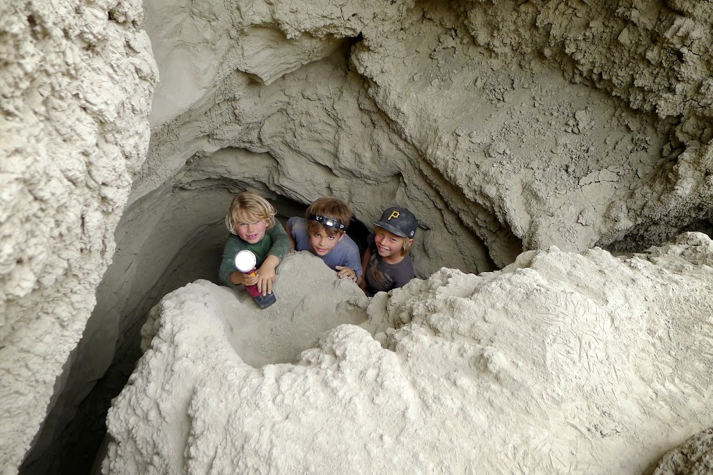
2/17/2014
Topic:
Blair Valley and Mud Caves with the Kids
mrkmc
|
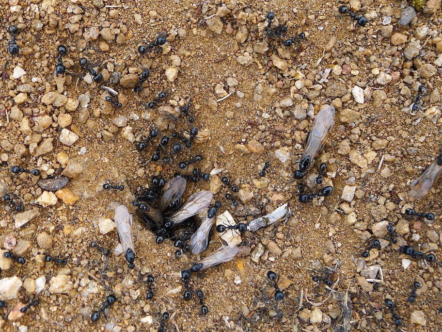
My buddy and I took the kids out to ABDSP for the weekend. We camped at Blair Valley since there is a bathroom, which is very helpful with 5 kids under 8. It was in low 90's Saturday afternoon when we arrived. The late afternoon was pleasant and we explored some near by sights while the sun was setting. I think the low was only in the mid 40's and it warmed up early Sunday morning. We took the kids down to explore the mud caves. They liked riding in the back of the truck on the dirt roads more than the caves. I think they just like playing in the dirt more than anything. After the caves we explored some boulders and saw some neat artifacts. I have been roaming to other parts of the desert over the past few years, but ABDSP is still my favorite and has some much to see.
Kumeyaay Slide?

Interesting ants, some with wings. Anyone know anything about these?
exploring
Rosey Boa confused by the warm winter?

one of the nicest arrowheads I have seen. Not sure what type of rock it was, buy very dense.

the rest of my pics are here: https://picasaweb.google.com/112918892253657164707/AnzaBorrego?authuser=0&feat=directlink
edited by mrkmc on 2/18/2014 |
2/18/2014
Topic:
Blair Valley and Mud Caves with the Kids
mrkmc
|
hmmm, try this one: https://picasaweb.google.com/112918892253657164707/AnzaBorrego?noredirect=1 |
2/18/2014
Topic:
Blair Valley and Mud Caves with the Kids
mrkmc
|
dsefcik You guys didn't climb up to the top of Quake BM did you?[/quote wrote:
Nope, didn't go to Quake BM, just the unnamed peak (+2760) west of Foot and Walker Pass.
rockhopper wrote:
Did you find that in Blair valley or mud cave area. The visitor center would love that one!
Neither, it was right by some rocks and some cactus. I think its much happier staying right where it was. |
2/24/2014
Topic:
Show us your Cholla bomb photos
mrkmc
|
Not me, but I love this pic:
 |
2/24/2014
Topic:
Sandstone Canyon Discovered
mrkmc
|
Nice! I saw Leo's card in another register a few years ago:
 |
3/22/2014
Topic:
Some benchmarks and Truckhaven Trail, March 2014
mrkmc
|
Nice trip! I still need to visit Paint BM. Lute is interesting in that it is a scarp from the Clark strand of the San Jacinto fault zone. I wonder how much, if any, the BM has moved since 1940. |
10/14/2014
Topic:
Ghost Mountain with Huel
mrkmc
|
http://www.desertusa.com/dusablog/ghost-mountain-hike-huell-howser-unseen-ghost-mountain-episode.html |